“Mud, Rock, Blazes” written by Heather Anderson and read by Chelsea Stephens
This post may contain spoilers.
This was a fascinating insight into the mental challenges faced by an endurance athlete. Unlike all the other books I’ve listened to and read on the Appalachian or Pacific Crest Trails this walker was trying to set a record. Heather Anderson (Anish) already held the Fastest Known Time (FKT) for self-supported completion of the PCT in 2013 but riddled with self-doubt and insecurity she had herself convinced it was a fluke. With incredibly low self esteem and a failure to set an FKT on the John Muir Trail she decided to give herself one last chance and aim for an FKT on the AT in 2015. Not content with the female record she set herself a huge challenge of the overall FKT requiring an average of 50 miles per day to complete in just over 50 days. An average of 3-4 miles per hour meant sleep deprivation, no rest days and a constant battle to keep fuelled and hydrated while fighting exhaustion as well as the mental torment of having set a daily target that simply wasn’t achievable.
Unlike all the other AT and PCT stories this is all a personal journey and a story about her personal battles. Don’t read this if you want to know about the trail itself or about the characters that you might encounter. However, if you want an insight into the mind of an endurance athlete and what it takes to keep going day in, day out this is the book for you. In today’s world of airbrushed and sanitised perfect lives depicted on social media this was incredibly frank and honest and dealt with her negative self image as much as the achievement of battling through conditions that most people can’t even contemplate.
The difference here between 4 and 5 stars was the narrator. She reads at the start in a kind of breathless and over dramatic way that kind of trivialised the author’s achievements and feelings. I don’t know if she moderated this as the story progressed or if I stopped noticing it but it definitely became less of an issue later in the book.
This is the second audiobook I’ve listened to that came from recommendations on Splodz Blogz weekly blog Episode 110. There’s a third one in there that is next on my list.
Where’s the Next Shelter? is the true story of three travelers on the Appalachian Trail, a 2,000-mile hike that stretches from Georgia to Maine, told from the perspective of Gary Sizer, a seasoned backpacker and former marine who quickly finds himself humbled by the endeavor. He teams up with Megan, a sassy college grad whose indomitable spirit eclipses her lack of experience; and Lemmy, a cartoonist from overseas whose off-kilter commentary on the wonders and frustrations of the trail keeps everyone laughing.
Sprawling through the woods and towns of the Appalachian Mountains, the trail carries the trio through real and fanciful ups and downs ranging from hilarious to perilous. Much more than an orderly account of mountaintops and meals, this book is an adventure about friends figuring things out as they go. It’s about screwups and solutions, awe and inspiration.
If you long for the horizon or to sleep under the stars, then come along for the hike of a lifetime. All you have to do is take the first step.
My Rating: ⭐⭐⭐
Yes, yet another audiobook on long distance hiking and my second in a row on the AT! This one took a bit of getting used to. The author reads his own story and he reads at a speed that is slightly too fast for comfortable listening. He also has a slightly irreverent attitude that while novel means quite a lot of swearing. Hearing fuck in an audiobook conversation while not shocking is kind of jarring and I was nearly at the end before I was getting used to it.
A consistent element of the story style is the author recounting conversations as they happen and verbatim. I find it difficult to believe that he was able to recall so many conversations over such a long period of time and almost a year after finishing the trail.
Sizer himself is an interesting character and I found his friendship and relationship with other hikers and trail angels really well written and described. In particular his special relationship with Voldemort (Megan) and Lemmy is particularly enjoyable.
Another good depiction of the AT and I found it particularly interesting how Sizer’s description was different to that of David Miller’s while still staying so similar in many ways.
In 2003, software engineer David Miller left his job, family, and friends to hike 2,172 miles of the Appalachian Trail. AWOL on the Appalachian Trail is Miller’s account of this thru-hike from Georgia to Maine. Listeners are treated to rich descriptions of the Appalachian Mountains, the isolation and reverie, the inspiration that fueled his quest, and the rewards of taking a less conventional path through life. While this book abounds with introspection and perseverance, it also provides useful passages about hiking gear and planning. This is not merely a travel guide; it is a beautifully written and highly personal view into one man’s journey and the insights gained by abandoning what is comfortable and routine.
My Rating: ⭐⭐⭐
I listened to this straight after “Journeys North” and I think it would have been more enjoyable with a gap between the two. It’s also the very first AT based audiobook for me and it seems that the PCT is a much more diverse adventure and also seems to attract a more interesting participant. This means that while the author is interesting and has his own good back story those around him seem less so. Again this could be due to comparing everyone to Journeys North.
I did enjoy the writing style of the story which kept it tipping along at a steady pace. He also provided a lot of information about the AT itself and I felt that I knew it much better at the end compared to Bill Bryson’s book which was more about his experience than the actual trail.
At a similar age to the author I found great admiration for how he was able to recognise the way his career was affecting his mental health and happiness and was able to change the script of his life with the incredible support of his wife. I was really glad he filled us in at the end on how he returned to real life once again.
My only regret with this book is that I should have listened to it before Journeys North.
I’ve read and listened to a lot of stories about long distance hikes over the last year or so. From Bill Bryson’s adventure on the Appalachian Trail (AT) to Cheryl Strayed on the Pacific Crest Trail (PCT) and recently Reg Spittle’s second book about trekking in the UK and Europe. I’ve just started yet another PCT themed audiobook, by Barney Scout Mann, entitled Journeys North.
In the opening chapters Mann mentions how some hikers walk long distance trails in sections rather than thru-hiking the entire trail in one go. This has been mentioned in every story so far but yesterday it seemed to have found more fertile soil in my brain and I started considering my own options for section hiking.
Close to home I have a number of waymarked walks. Of Ireland’s 42 National Waymarked Trails there are 5 in Donegal. Of these the only one I’ve walked is The Bluestack Way. I walked the Glenties – Lough Eske section of this almost 10 years ago as a charity walk for the Bluestack Foundation, approx 30km in 9 hours was, and still is, my longest day’s walking.
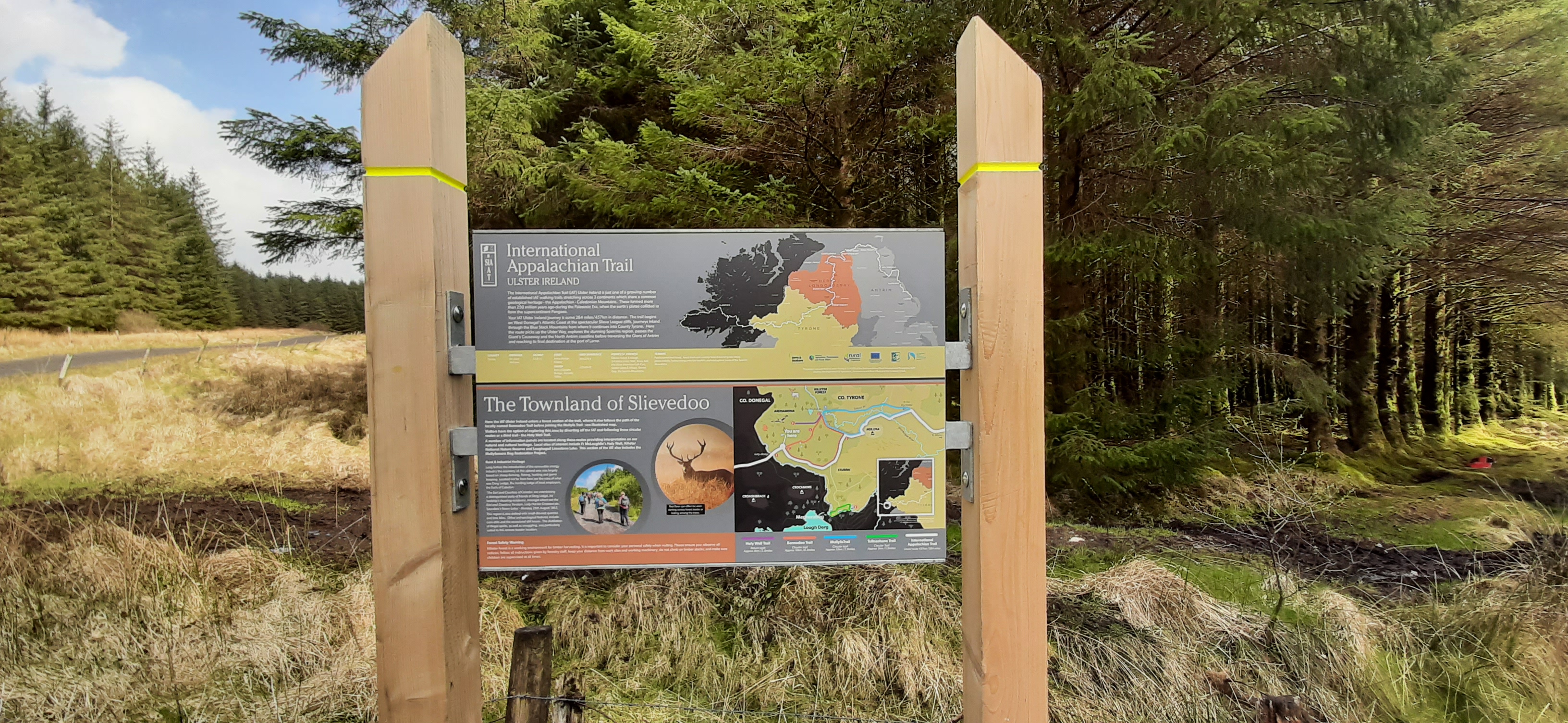
Three long distance walks also pass near my home. The Irish leg of the International Appalachian Trail (IAT) approx 450km from the Slieve League cliffs in Donegal to Larne in Co. Antrim, The Ulster Way, a looped trail just over 1,000km that circles Northern Ireland and The Ireland Way that is also 1,000km from Castletownbere in West Cork to The Giant’s Causeway in Co. Antrim.
the international appalachian trail – ireland
the ulster way
the ireland way
All three routes meet and overlap at the border between Donegal and Tyrone and follow the same route until The Giant’s Causeway where The Ireland Way stops. The IAT carries on with the Ulster Way until Larne where it stops before skipping across The Irish Sea to Scotland.
Many years ago I read one of the few books on The Ulster Way by Alan Parker and first published in 1989. Alan was the first ever person to walk the entire Ulster Way in 1979. It’s a really interesting read for more than just the walk itself. Alan was a real old school hiker and used B&B accommodation all the way. It’s a fascinating glimpse of a different pace of life in Northern Ireland at the end of the 70s and surprisingly unaffected by The Troubles.
I was familiar with the Ulster Way having seen the signs on many occasions throughout Northern Ireland and reading this book gave me my first real desire to do a long distance walk. However, 30 days is difficult to fit into any life when work and family also need attention so unfortunately it never happened.
The idea though has never left me so it’s unsurprising that it was The Ulster Way that I turned to today to investigate the possibility of section hiking. WalkNI have a very detailed section on their website that details a variety of different 1, 2 & 3 day and 1 week suggestions and there are 2 that really appeal.
Belcoo – Belleek: a 47km section including the optional Lough Navar loop. This is an area I’m very familiar with and Lough Navar has an amazing viewpoint looking out over Lough Erne. Possible as a day hike but more enjoyable over 2 days.
Lough Bradan – Gortin: 60km and recommended as a 2 day walk. Being close to home this is a very familiar area and although I’ve walked or cycled some of it, most of the route would be new to me.
In the middle of a very wet, cold and stormy February it’s nice to look at these routes and dream of long days walking and camping in warm sunshine (ideally!).
I’ve written already about finding it difficult to get motivated. In particular I’m finding it difficult to get motivated to go out cycling. In order to distract myself from this and maybe create a new desire to go cycling I’m doing two things. The first is to start back on the MTB with the Club group for the winter evenings. I used to do this a few years ago until the rest of the guys switched to Zwift instead. I need to do a little bit of TLC to my MTB and get over this head cold so it will probably be another week before I get organised for that.
My second plan is to get out and do some hillwalking again. Once I started cycling I pretty much stopped hillwalking but I’ve always enjoyed both the planning and execution of walking trips. I’ve also included some hillwalking challenges in my 50for50 list.
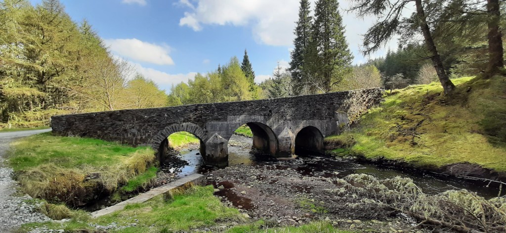
I was off Wednesday last week* as usual so decided to start straight away. I wanted something reasonably easy in terms of both planning and navigation to get me started so I chose a small enough hill called Bolaght Mountain (345m) South of Castlederg and approximately 40min drive from home.
I’m not a fan of “there and back” routes so devised a circular route based on the comments of other MountainViews members starting and finishing at the Sloughan Glen car park. Just under half the route was forest trails, a couple of kilometres was across the upland moorland and the rest on quiet country roads. The route was 14km plus the diversion to and from the actual summit of Bolaght giving a total of 15.5km.
Getting out of the car there is an immediate awareness of the local windmills. The steady breeze had the windfarm operating at full capacity and the noisy whoosh of the blades was very evident. Windmills are a constant companion on this route and if you aren’t a fan then this walk is definitely not for you!
Turning left out of the car park you then take the first road on the left marked as a dead end. It’s immediately uphill on a short, steep gradient through trees and high hedges. After a few hundred meters it levels off and opens out slightly to give views of the surrounding countryside. For the first 1-2km the road is tarred but soon turns into a gravel track but not too badly worn. One of the member comments on MV must have been here at the same time of year as he mentions the rowan trees and the berries. They were laden down for my visit too and lining both sides of the track.
Keep following the track past the entrances to the windfarm. Eventually you reach a farm gate. Cross this into a rougher track and follow this, above the river glen, over the bridge and into the forest by crossing a second gate. Don’t be tempted to take any of the windmill tracks as they will veer off in the wrong direction or dead end leaving you with rough, boggy ground to cross.
In the forest follow the forest roads and signs for Bin Mountain Windfarm.
On my visit the forest was misty and moody with the trees heavily draped with thick, green moss. I’d say this is a pretty wet location and I doubt if The Forestry Service will get much timber yield from here. Near the top of the hill make sure you veer left, still following the signs. The track takes a big dip and ahead it looks like a wall to be climbed!
Near the top I caught the flash of a deer darting into the trees. I’d say it had plenty of warning as I puffed my way uphill!
At the top of the ridge the track opens out of the forest and on to the open moorland mix of heather and coarse grass. You’re now in the windfarm proper, once you pass through one final gate, and suddenly Lough Lee appears in the hidden depression.
At the Eastern end of the lough the Ulster Way meets (or leaves depending on your perspective) the windfarm tracks. I started off following this but I should have headed straight for the summit at the signposted junction.
I was a few hundred metres along the Ulster Way trail before I realised my mistake and that I was moving away from the summit. I left the trail and headed straight up the ridge towards two small conifers. This was tough, knee-breaker ground and it took concentration and a good eye to avoid stepping in a hole hidden beneath the deep heather and grass. Thankfully the ground was well drained and pretty dry despite the recent rains. Once on the ridge it was a simple matter of heading West to the summit coordinates. The mapped summit is just beside a low, worn down fence and despite there being no markings it’s a fairly clear grassy patch, slightly raised above the surrounding heather. There’s a clear view down to Lough Lee and great views North over the countryside towards Castlederg.
summit pose
summit360
Standing at the summit and taking a bearing back to the Ulster Way trail I could see what looked for all the world like a road sign. It looked to be in the right location and was a perfect marker so I headed in that direction across the ridge. I was expecting this to be a real slog but once again the ground was much drier than expected and there were faint trails (probably from sheep) that made the going much easier. Before long I met the trail and chuckled to myself that the road sign was just that even if it was a bit the worse for wear!
The next few kilometres followed the Ulster Way to the alternative starting point at the head of a very minor rural road. The trail is reasonably well marked with a variety of very old, weathered and sometimes broken wooden posts and metal posts (about 25mm thick and knee high). The markers are every 100-200m but the metal posts are sometimes difficult to spot. I only had difficulty spotting the next one on one occasion where it looked like one marker post had disappeared completely. The next one was just about visible in the distance but took me a few minutes to spot. I don’t think this would be a great trail in poor visibility unless your navigation skills were particularly good. There seems to be recent quad activity along the trail which helps with route finding. So far it hasn’t torn up the ground too badly and hopefully it’s just local farmers getting access to the high ground and doesn’t deteriorate any further.
At the end of the Ulster Way the trail returns to tarmac roads and stays on them for the remaining 8km of the route. It’s not all bad though as this is a very sparsely populated area with only the occasional isolated house or farm. The roads are very minor rural roads and I only encountered one car the whole way and that was the postman. The scenery for the first few kilometres is really good with lovely views out over the valley below in the triangle between Castlederg, Drumquin and Newtownstewart. Clouds were low with incoming rain but on a clear day there should be a good view towards the highlands of Donegal and also the Sperrins.
The first section of road was very nicely lined on but sides with a fantastic display of fuchsia bushes. They’re a common sight on the North Coast, especially around Ballycastle and The Glens of Antrim but I haven’t seen them this far West like this before.
Lunch was had about a kilometer later in the shelter of a stand of conifers just past Slieveglass (in Irish: Green Hill) Windfarm. The trees gave a pleasant break from the strong, blustery breeze and allowed me to set up the gas stove and make a welcome cup of tea to accompany my sandwiches.
Heading off again I soon realised that the trees had protected me from more than just the wind. The cloud had closed in obliterating the view and bringing a steady, heavy drizzle that soon turned to proper rain. Hunkered down in a bit of a hollow for lunch I’d been blissfully unaware.
Although the area is now very sparsely populated there is ample evidence that it wasn’t always so. There are quite a number of old buildings. Some are almost ruins while others have been repurposed to shelter animals or to provide farm storage. There was even an old, abandoned schoolhouse. The inscription above the door was just about visible and suggested it was built in the mid 19th century. With so many buildings being abandoned it was nice to see one, close to the car park, being renovated and extended.
huge fireplace about all that’s left
schoolhouse
A few kilometres later the road turns back towards Sloughan Glen. The terrain changes again and the roads are now protected by high hedges and small wooded areas. Some of these areas were grazed by sheep or cattle but most seemed abandoned, another sign of the decline of the local population.
quiet roads
The final approach to the car park is along the banks of a small river. Its seems to flow from the main glen and is most likely the same river followed and crossed near the beginning of the walk. This area is the hunting grounds of a large adult grey heron who didn’t seem overly impressed to have me plodding through. He kept rising up and circling around. He was a bit worked up but giving me a great display.
15.5km brought me full circle and back to the car. However, I decided to go into the actual Sloughan Glen to walk the path and view the waterfall. The steep paths and many steps were a challenge for tired legs and achy knees but more than worth it. The area is an ASSI and absolutely beautiful. Two of the waterfalls were in good flow but I was surprised to see one of them dry despite the recent rain.
In total I finished with almost 17km and a thoroughly enjoyable day despite the constant rain for the second half. The road walking may not suit everyone but I enjoyed the variety of the route.
Yesterday morning was fabulous. Very calm and sunny and despite an early frost it was lovely. After the school run I came home and organised my bike and kit all ready for a late morning spin. First though I had to wait for the guy to come and replace one of our worn out electric showers. With two teenage boys back at school and both of us working one working shower is no longer enough in the morning!
The shower man came about 10 and left about 1130. I don’t know if it was spending the morning making small talk and listening to his stories or if it was the change of weather from sunny and calm to overcast, cool and breezy but my cycling desire had totally evaporated and the thought of dealing with traffic was totally unappealing all of a sudden.
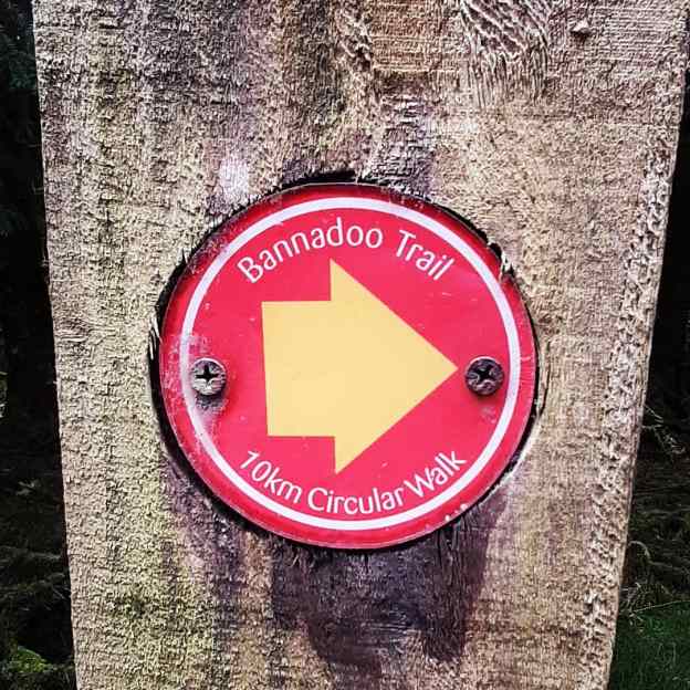
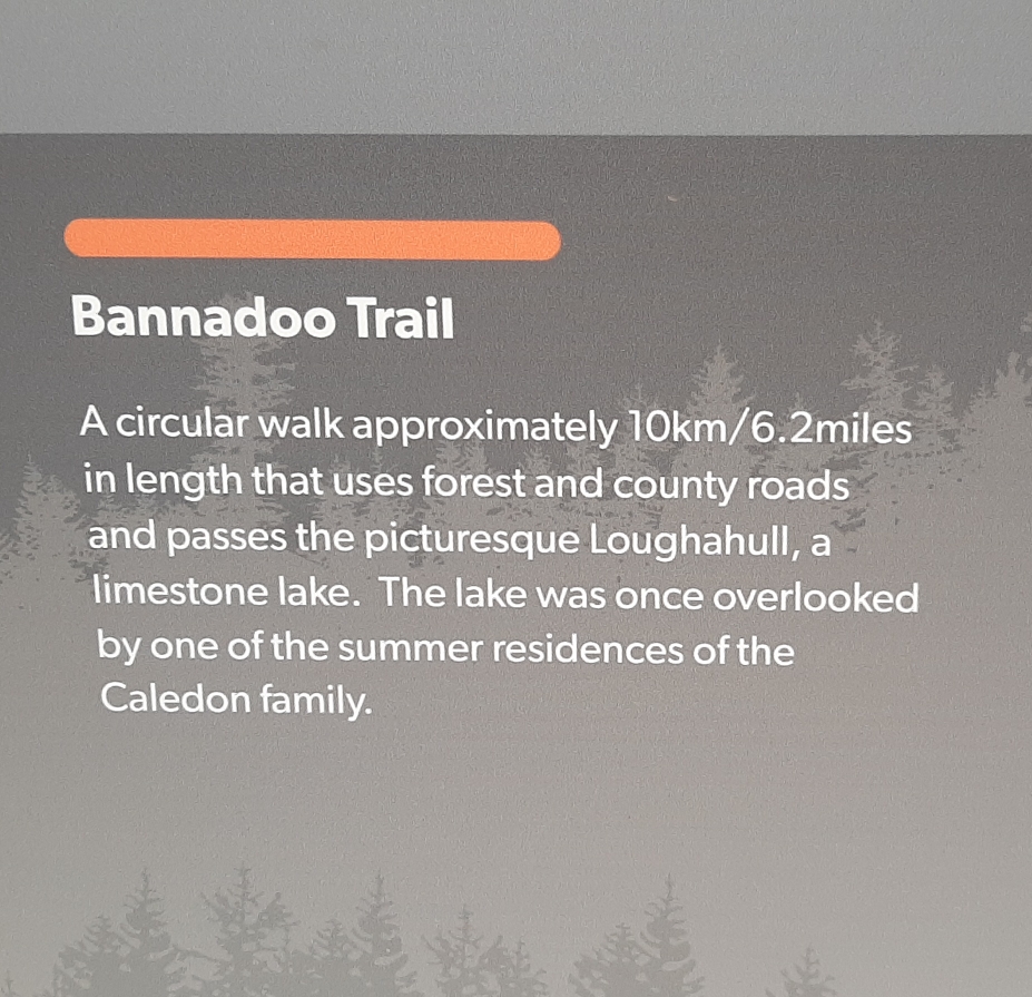
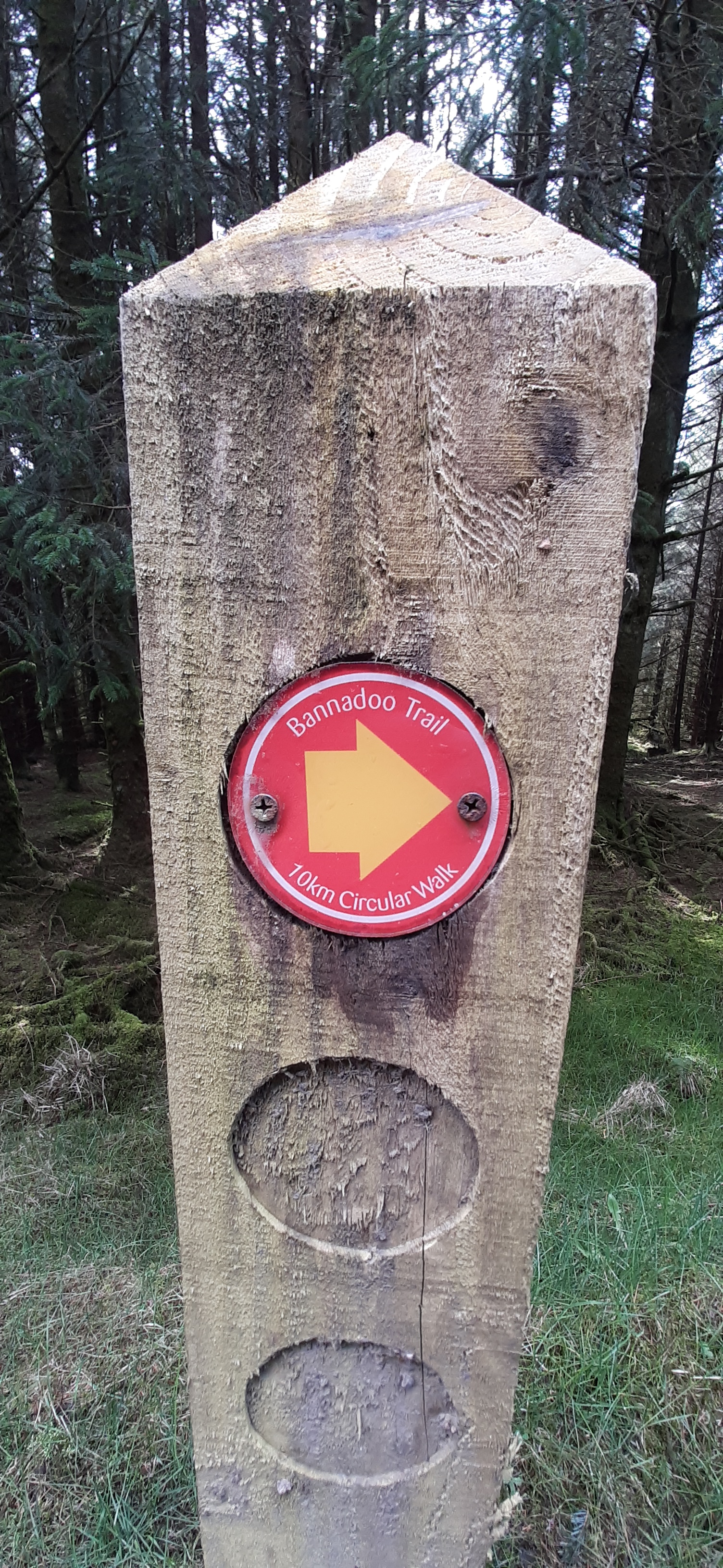
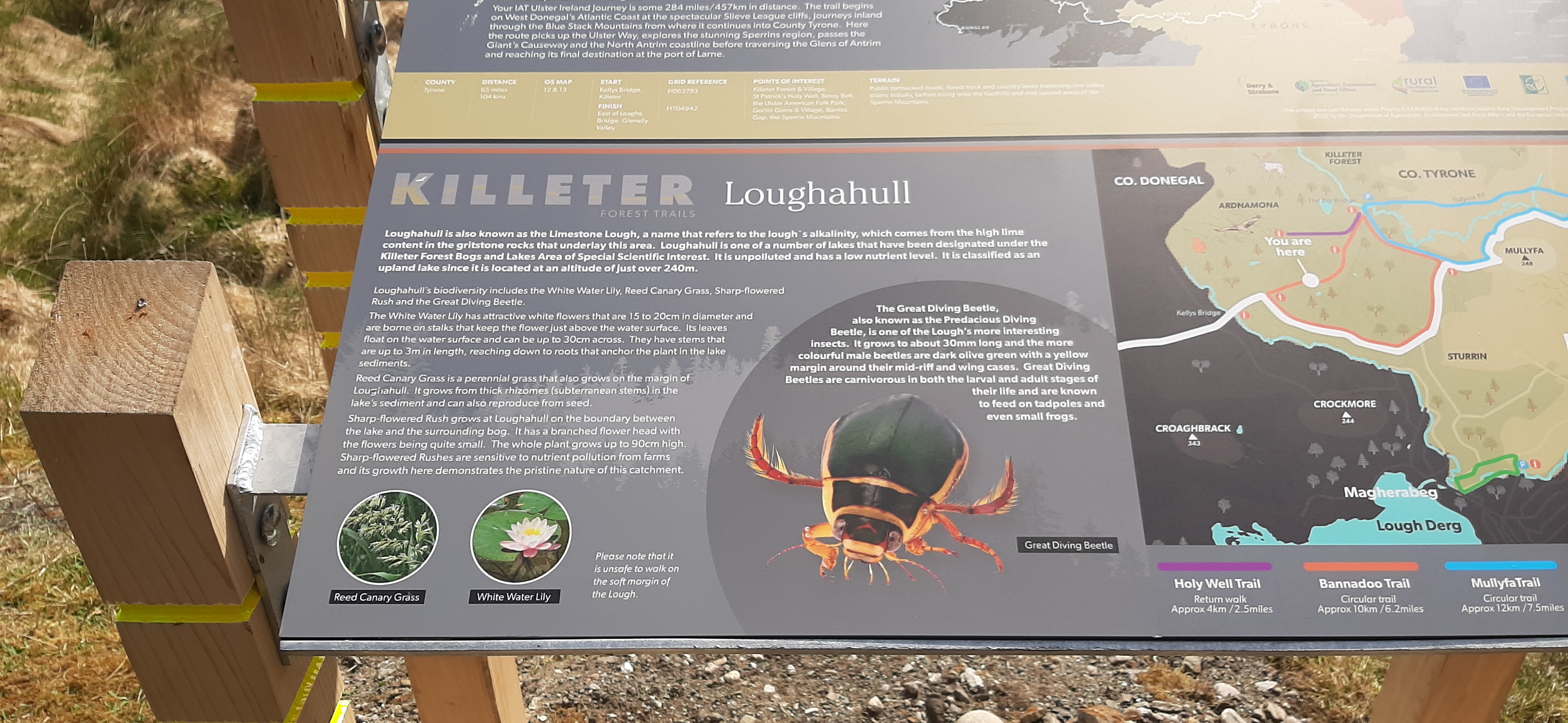
I was rattling around the house trying to think of something to do when a flash of inspiration brought to mind Killeter Forest and the marked trails. A quick perusal of the pdf established that the 10km Bannadoo Trail was the best option.
Over the last number of weeks I’ve been drawn more and more to the woods. Something about woods and forests and being in the trees is helping me mentally, a form of forest bathing as referenced above. My go-to place for many years has been Monellan Woods. It’s local and relatively quiet until the last year or so. Over the years I’d rarely meet anyone else while walking there, occasionally another walker or runner. Since Covid and an explosion in outdoors activity word has obviously spread and now it’s a lot busier. Tuesday evening for example I met at least 6 other groups/solo walkers and runners. It’s still a beautiful spot but it’s lost a lot of it’s calm and solitude.
I didn’t have this problem in Killeter. Almost 7.5km is on forest roads with the rest on a very rural road. Apart from the surface there isn’t much difference between the road and the forest tracks as the road also runs through the same mix of mature Spruce plantation and clearfell. The only company I had for almost two and a half hours was the trees, hundreds of singing birds and insects. Not another person or car the whole time.
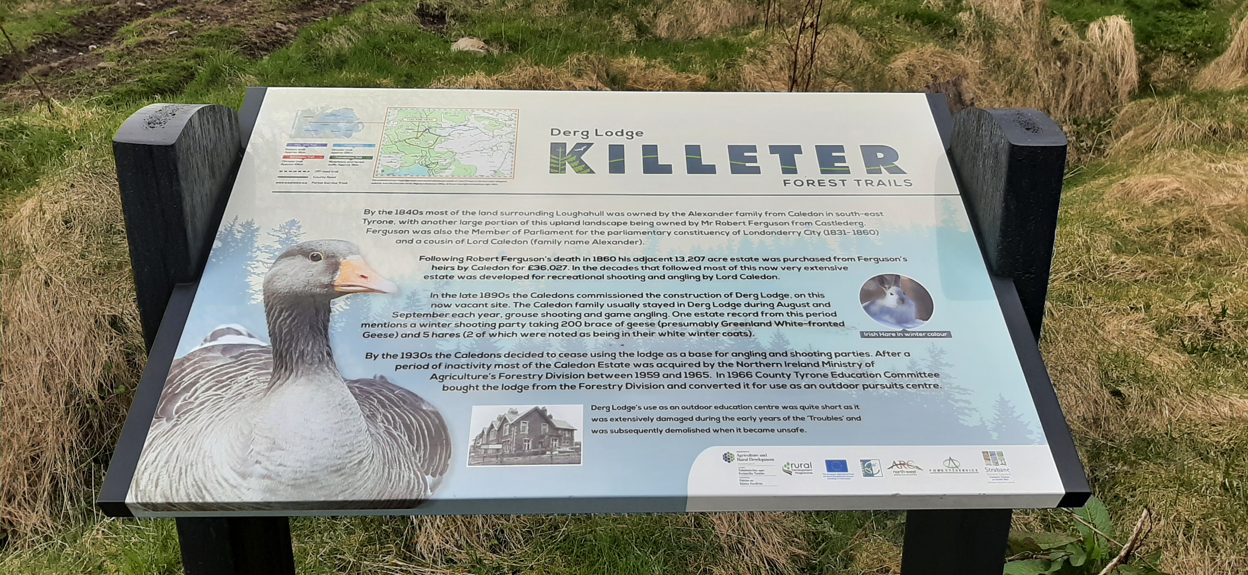
The walk turned out to be almost 11km including the short walk from the car park area to the start of the loop. Most of it is through mature plantation so the views are minimal but there’s a beautiful lake in the last couple of kilometres as well as the site of the former Derg Lodge. Although I missed out on a cycle it was a worthwhile change of plan.
international appalachian way
damaged during the “troubles” = blown up by the ira
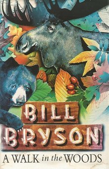
The Appalachian Trail stretches from Georgia to Maine and covers some of the most breathtaking terrain in America—majestic mountains, silent forests, sparking lakes. If you’re going to take a hike, it’s probably the place to go. And Bill Bryson is surely the most entertaining guide you’ll find. He introduces us to the history and ecology of the trail and to some of the other hardy (or just foolhardy) folks he meets along the way—and a couple of bears. Already a classic, A Walk in the Woods will make you long for the great outdoors (or at least a comfortable chair to sit and read in).
My Rating: ⭐⭐⭐⭐
I came to this book having watched the film a few days ago. The film is decent but I had a feeling there was more to the story in the book. In an unusual flip I found the book was enhanced by having seen the film. Sure, some of the scenes were modified, switched around or simply invented for the film but the spirit of the book is definitely there. What really enhanced the book though was Nick Nolte’s excellent portrayal of Katz. I couldn’t help but see and hear him jumping out of every page and piece of dialogue. Despite how it happened he ended up being a perfect casting choice.
Katz is the success of this book. Bryson himself is very straight, introspective and sometimes abrasive and arrogant. Katz provides the comedic element but also some of the most emotional and thought provoking parts of the story.
It’s hard to think of this book as non-fiction or a travelogue but it’s both. There are lots of negative reviews on Goodreads, mostly based on a negative view of Bryson but I really enjoyed it. It provides a great view of what it’s like to walk a long distance trail and also a nice historical record of how the AT came about. There are many interjections about how the nature of the American wilderness has and still is changing. Probably one for people interested in hiking and camping though.