Yesterday marked what I hope is a new start for me on my cycling journey. My cycling activities have declined significantly starting in the second half of 2021 but completely collapsing during 2022 with only 860km in total and my longest ride being slightly over 56km back in May.
Some of my decrease in activity I put down to a decrease in Club group activities during Covid. The majority of my cycling in 2020-21 was solo and I’ve always found it more difficult to self motivate. The social aspect of Club riding can be challenging at times but overall I found it having a positive effect. As my cycling became more erratic during 2021 and I lost fitness I found it increasingly difficult to take part in Club activities as the group I was a part of became too strong for me and I couldn’t stay with them. I did do some rides with this group and while a few of them were understanding and helpful it quickly became frustrating for everyone and I stopped riding with them. I then found it difficult to find a new group that I fitted with as comfortably and the Club became less attractive for me. Then I got into a spiral of decreasing interest and declining fitness resulting in my worst year since I started cycling back in 2013.
The other reason for my lack of cycling motivation last year was the lack of a goal. Yearly distance goals are too long term for me and a randomly selected weekly mileage doesn’t really motivate me either. My two best years on the bike were 2016 and 2017. It’s no coincidence that I was very active with the Club in 2016 and had two big events that year.
Wicklow 200: June 2016
Causeway Coast Sportive: September 2016
In 2017 I discovered Audax and that gave me a series of goals to work towards that year with the 4 Provinces Challenge. It’s also significant that my cycling dropped off very quickly shortly after I completed that challenge in October 2017 and 2018 was a much poorer year without a specific goal to aim for.
All that is a long way of saying I’m planning to turn things around by setting myself a goal for 2023. I turn 50 this July so as well as having a goal I want it to be something special as a milestone for the year. I’ve decided to take on the Audax Super Randonneur Challenge. This is a series of Audax events that comprise the full set of distances and requires completion of at least one each of a 200km, 300km, 400km and 600km event during the Audax calendar year (November 1st – October 31st).
I have selected 4 events that will also allow me to complete the 4 Provinces Challenge for a second time as events can be used to qualify for more than one challenge at a time. The first of these events is the Dark Hedges 200 on April 23rd. This is a route I’ve ridden a few times now and one I’ve enjoyed. It’s a challenging route with a lot of climbing in the second half but will be a good test of my fitness and an indicator of my chances of success at the longer distances.
My first ride of the year and my first step on the road back to Audax fitness was yesterday afternoon. A simple 27km with a little climbing to break me back into the cycling habit. My “plan” is to use this loop to rebuild my cycling habit and some form of base fitness throughout January by completing it 3 times each week. In February I’ll start to increase the distance and elevation and add in some more structured training. For now though I want to focus on getting back to a regular cycling routine.
Header image by alexandre saraiva carniato from Pexels.com
Part II of my daytrip to The Mournes. Part I can be found here.
Leaving my lunch spot was a bit of a wrench. Despite the slightly chilly low breeze I was comfortable in a light shell jacket and the views were fantastic. I could see right down into Hare’s Gap and see people climbing up along the Trassey Track with some just aiming for a picnic at the top of the Gap with others heading on along The Brandy Pad, or turning up to Slieve Bearnagh, or towards me and Slievenaglogh. Watching people climb up towards me I could see that I was in for a steep descent but I’d rather be going down than up!
When I did finally push myself to leave this lovely spot and pack my gear back in the bag I soon dropped down to Hare’s Gap. The path was steep and seems to have suffered badly with erosion over the years. However, grounds work has been done to remedy this with rocks placed on the worst sections. It’s unavoidable that some of these now resemble steps but I was impressed how well the work has been done to blend in with the natural environment.
The Brandy Pad
Hare’s Gap was a busy spot. It marks a crossroads of sorts in The Mournes and the meeting of The Trassey Track and The Brandy Pad at The Mourne Wall. These two paths have their origins as old smuggling routes over The Mournes from the coast. Smugglers used ponies to carry goods across the mountains to avoid revenue and coast guard officers. Today it was walkers with a couple of groups using the Gap as a convenient lunch spot while a couple of families with young kids were having a picnic. It was a nice spot but busy having spent the morning alone and I was happy to move on once I’d had a look around and enjoyed the views down the Trassey Track.
With such a long history it will be no surprise that the Brandy Pad was a very clear and well defined path. I was pleasantly surprised to find that it was managed to only a very low level and left as natural as possible. There were a number of small streams flowing down from the hills I’d walked earlier and as I came close to the path up Slieve Beg, I was accompanied by the sound of the river in the low ground below as it rushed its way down to eventually reach Ben Crom Reservoir.
The track feels mostly level but looking forward from Hare’s Gap it was obvious that there is a bit of a climb towards the end as it rises towards the base of Slieve Beg before dropping again slightly. It is in this area that I had my best view of the rocky cliffs below Commedagh known as The Castles.
The track drops down to a small area that has the feel of a gorge about it as a small stream cuts across the path. I barely got my soles wet today but I have a feeling this would be a more impressive crossing after a period of heavy rain.
If you follow The Brandy Pad to its end you will come out on the coast at the gruesomely named Bloody Bridge. However, my path veered to the left heading around the side of Commedagh and making for the col between it and Slieve Donard. This section of path gave me a brief but scenic view down Annalong Valley with a very different feel to the one I’d just climbed out of. Annalong isn’t dammed like its neighbour and the river has been left to wind its way gently down the valley.
Donard
Rounding the shoulder of Commedagh the path rises gently again and back towards The Mourne Wall. The Wall passes over both Donard and Commedagh and drops down into the col between the two. A large stile marked the spot where my path crossed and as I got closer I could hear the steady murmur of voices. Climbing over there were a lot of people around, I only thought Hare’s Gap was busy. There were all sorts here from young kids to senior citizens, all shapes and sizes and everything from trainers and shorts to the likes of myself in full hiking gear. The col is at approximately 550m and the large flat area with the wall to break any breeze is the perfect spot to gather your breath after the climb up from Newcastle before the big push to the top of Donard. For others it was a chance to revel in a climb completed and to rest aching knees having scrambled back down. For me the number of people and the constant murmur of voices was jarring and unwelcome. I should have known better on such a good day and a public holiday.
Standing in the col the top of Donard is visible. The summit cairn is out of sight but close by there is one of the towers that are sprinkled along the length of The Mourne Wall. The top of this was clear to see from below as a slow chain of people dotted the way up the side of the mountain. It’s an intimidating sight with a climb of approximately 300m in just 1km. I somehow managed to coax my tired and achy legs into one last climb to the top of Ulster.
The climb to the top of Donard is a real slog! It’s relentless and with 11.5km in my legs before starting I really felt it. In an ideal world I would have left my bag at the col and retrieved it on the way back down but this wasn’t an option with so many people around. The path is simple to follow and despite the high traffic this mountain gets I was surprised again how low impact the path management is. There are some sections that have been eroded more than others but once again the measures in place blend well with the natural environment.
I had hoped for one long last push to the top of Donard but in the end it was a series of smaller efforts while I paused to allow other walkers to descend – nothing to do with needing a breather myself of course! The one advantage of such a steep climb is that every step gains you quite a bit of height and before too long the summit was coming into view. The weather was a little breezier up top at 849m. A bank of mist was sitting just off the coast and at times clumps were drifting across to Donard before dissipating leaving it cooler than expected. Like the col below, the summit was also busy with everyone, including myself, wanting the all important summit selfie. A Dad was trying to get two little boys to sit still on the cairn for a photo but they were more interested in building a little tower on the top by balancing stones. I couldn’t help but feel that the day would have been more memorable if he had helped them instead of worrying about the Instagram moment! I gave them a bit of space and then had my own 30secs of fame as the highest person on Ulster.
It was only when I looked back at these photos at home that I realised someone had plonked an empty water bottle in the middle of the cairn! I’d already lifted another out of a nook in the wall. It never fails to amaze and annoy me how someone can carry a full bottle all the way up here but suddenly find that it’s too heavy to carry back empty! I was encouraged to hear another man making sure his young kids were being responsible with wrappers and rubbish as they had lunch in the lee of the wall out of the wind.
I spent a few minutes enjoying the views from the wide top of Donard and had a good look at the tower before heading back down. It was pretty cool on top and too busy to make it an enjoyable spot for lunch. I decided to go back to the col and head away from the bulk of the people and find a quieter spot just off the trail with a nice view across the Pot of Pulgarve, down the Glen River and into Newcastle, the last bit of my journey and the reverse of the view I had just a few hours earlier.
While sitting enjoying my lunch a very friendly but completely random American lady came up and asked me if I wanted her to take my photo. I’ve no idea what prompted this offer but I politely declined and she carried on, still smiling. It was nice to see that there are still people around that make an effort to speak to strangers and engage. I was surprised on the climb up and down Donard how few people wanted to make eye contact or even just return a smile or nod but this woman restored my faith.
The Last Stretch
Leaving the col the path drops quite steeply to where it crosses the upper reaches of the Glen River. On the way down there are a number of smaller streams and mini waterfalls burbling beside and across the path. It was nice to cross the river on simple stepping stones as much of the upper reaches of this path are graded and gravelled due to the volume of traffic it gets. I was really surprised by the numbers of people I was still meeting on this path between 3 and 4pm, all heading in the direction of Donard and lots of them seriously under dressed for any change in conditions. For some of them they were looking at a minimum of 2-3 hours just to get back to where I met them which would have been close to sunset at this time of year. The one that most shocked me though was the guy with his arm in plaster to well above his elbow. His arm was in a fixed position with his thumb sticking out straight – bonkers!
Dropping steadily the path eventually meets the edge of the forest and the river really picks up speed and strength in the ravine below and multiple waterfalls catch the eye as you descend. Walking here was relatively easy, allowing me time to reflect on the day. As well as a sense of achievement having completed this mini adventure I was also a bit sad. While the day had been incredibly tough I’d really enjoyed it and I was sad that it was almost over.
For a brief period the path diverts slightly into the trees before bending back to the banks of the river. Coming down here there was a bit of evidence in the forest below the trees of illegal dumping and abandoned rubbish and a couple of old fire rings left by people either camping or drinking in the forest. Sickening to see in such a beautiful spot and disheartening that there hasn’t been more of an attempt to remove it. I’ve just finished listening to an audiobook that features park rangers from american state parks and part of their role is dismantling illegal fire pits and camps and disposing of rubbish. Ideally it wouldn’t be there at all but I wish someone would remove it.
For the final stretch there is a choice of path going either side of the river. I decided to go the opposite side than the one I came up by and took the right bank crossing the river by the bridge. Part way down I was treated to a beautiful waterfall as the river came over the edge of a massive round rockface.
This path definitely hasn’t been graded! It was very rough with large rocks and exposed roots ready to trip a weary and unwary hiker. Thankfully I and the other walkers nearby passed through with no mishaps and before I knew it I was back in Donard Park walking on the edge of the grass to get some respite from the sharp gravelled path for my poor battered feet.
My GPS told the same tale as Paddy Dillon with an 18km trip versus the estimated 16km and I definitely felt it. The original estimation was for 6-7hrs walking but according to Strava my moving time was 5hr33min which I was very pleased to see. I had allowed 8-10hrs and was complete in 8hrs03min which was way better than I expected. In fact I passed the original 16km marker at 7hr33min.
Overall a fantastic walk, one that really challenged me and most likely my hardest hike so far but incredibly rewarding. I can see why so many people return to the Mournes time and again and this definitely won’t be my only visit. Since the day of the hike I already have two other similar routes planned and mapped out!
This is a long walk and I’ve decided to break it up into two posts. The first is below and the second will follow in a day or two.
A few weeks ago I came up with an idea to head to the Mourne Mountains for a day hike. Up until now the closest I’d gotten to this was an aborted plan from at least 5 years ago, to do the same, that was cancelled due to poor weather and never revisited. In fact it may have been this event appearing in my Facebook memories that triggered a renewed interest.
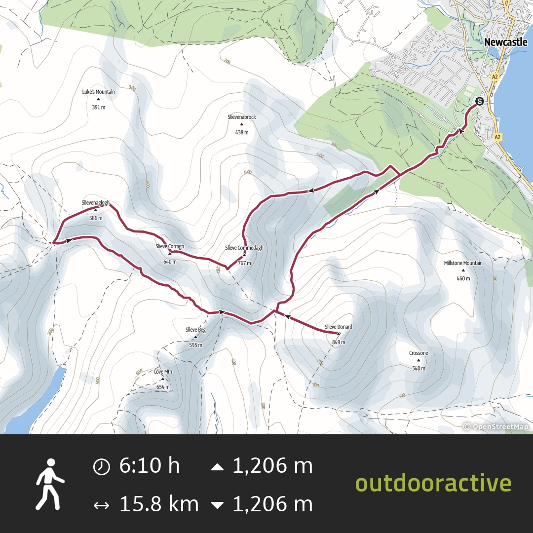
I reached out to a couple of friends for advice and did a bit of research on Mountainviews.ie and came up with a route that was 16km in length and with an intimidating 1200m of elevation gain. By complete coincidence I found out afterwards that this is one of Paddy Dillion’s recommended Mournes routes! It was probably good that I found this out after, rather than before, as the actual distance was 18km which might have put me off!
The route can be viewed on Outdoor Active but essentially takes in 5 summits including Slieve Donard (849m), the highest summit in Ulster, and Slieve Commedagh (767m) the second highest summit in the Mourne Mountains range.
From home to the start of the walk is approximately 2.5hrs driving and the estimated time for the walk was 6-7hrs. Allowing for breaks I estimated 8-10hrs so decided it made more sense to drive up the night before and sleep in the back of the van overnight to get a decent sleep and still get an early start to get home at a decent time. This made even more sense as my original plan for the walk was on a Sunday so I’d be finishing work in Omagh on the Saturday night and already 40min closer to Newcastle. In the end up that date was cancelled due to a bad storm on the Sunday. With the sudden death of Queen Elizabeth I ended up having a two-day weekend due to the Bank Holiday on Monday for her funeral. This worked really well as I was able to organise and pack on Sunday, leave home about 4:30pm and get to the parking spot before dark.
Vanlife
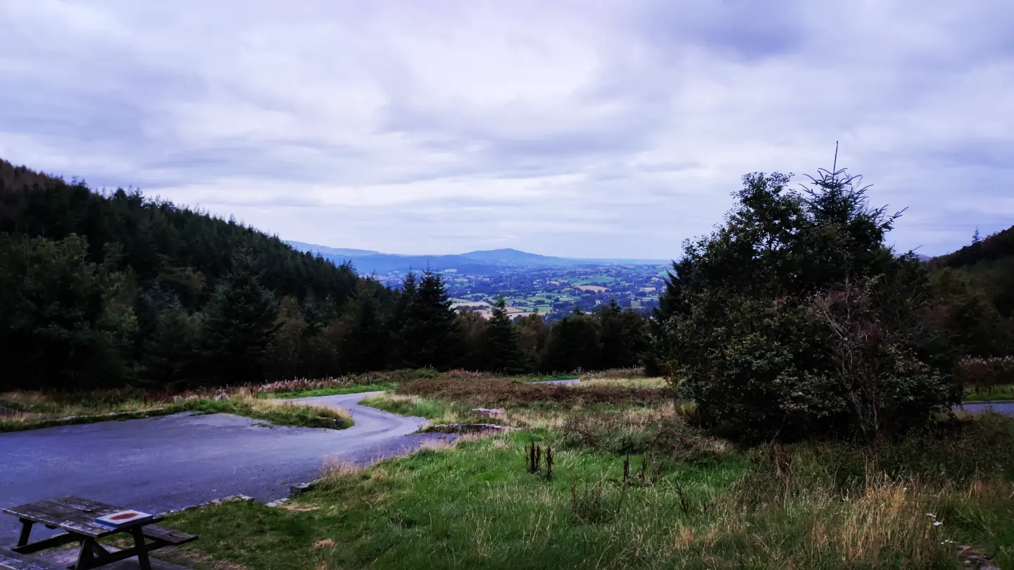
My initial idea was to try and park up in Newcastle at Donard Park which is where the route starts. However, advice from some friends was not to park in the centre of town and instead to use one of the actual camping spots. The two recommended were Meelmore Lodge and Tollymore Forest. The former came recommended by a number of people but £10 for a simple park up seemed a little bit expensive and reviews on TripAdvisor about a pushy owner, dirty facilities and noisy groups put me off. The latter was £20 for a night and at 20mins away didn’t seem like good value this time. The last recommendation was the one I went with. It was a car park in Kilbroney Forest, on the outskirts of Rostrevor, and only 25 min from Newcastle according to Google. My friend stayed there a couple of times in a car and had no problems so I figured that was good enough for me.
I arrived just before dark and only one other car was there, at the far end of a very large car park totally surrounded by a mature forest plantation and with a nice view out over Rostrevor town. Loads of picnic benches made it an ideal spot for parking and cooking my dinner.
As darkness fell a number of cars came and went and one car stayed around while a few others came to speak with him for a period of time. I have a feeling it may have been the local dealer but they were well away from me and paid me no heed so I ignored them also.
Despite nerves in the days leading up to the weekend I slept well. A noisy car woke me briefly at 1:30am and my bladder again at 3am but I had a good night’s sleep despite parking on a bit of a slope! There is a good surface in the back of the van, plenty of space and my sleeping mat and sleeping bags were plenty warm enough. The alarm woke me at 6am and I decided to head for Newcastle, have breakfast in the car park there and use the toilet facilities before starting my walk.
For some reason Google decided to send me by the coastal road which took almost 45min but I was fed, changed and ready to go by 7:30am. Unfortunately I had to delay my start until 8am for the timer locks on the toilet block to open and allow me in.
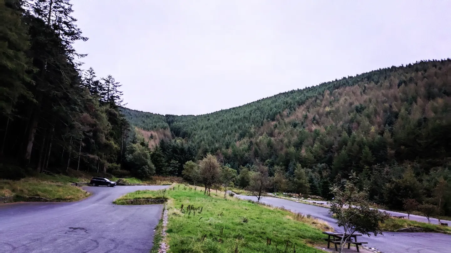
On the way over I passed another car park at a place called Bloody Bridge. I was specifically warned against using this place to overnight but passing by there were at least 3 campers there and the toilets seemed to be open at 7am. If I go back again I may consider using this spot as it is much more convenient but not as quiet, being on a busy road. In Donard Park there were also a couple of tents pitched up but I don’t know if this is officially permitted and chargeable as there were no signs either way.
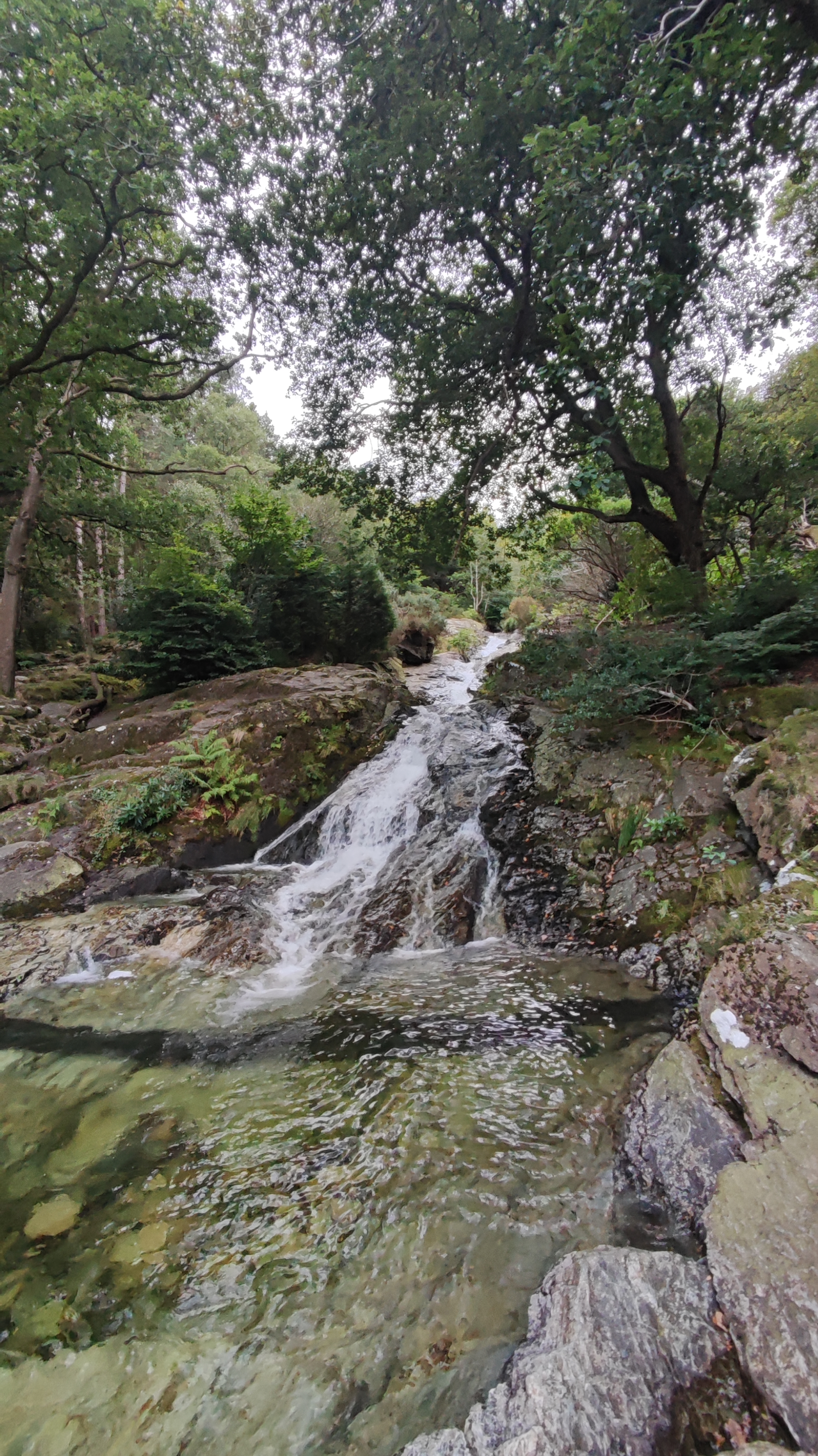
While waiting for the toilets to open a few other vehicles arrived and some people were heading up the trail to the hills already which didn’t help my natural impatience. When I eventually got started the trail headed along the edge of Donard Park (past the aforementioned tents) and straight into the forest. The trail follows the noisy Glen River all the way to the col between Commedagh and Donard and this is a very picturesque scene with multiple waterfalls, narrow ravines and bridges. The trail is heavily travelled with many tree roots visible above ground, polished and hardened by thousands of feet. Exposed rocks combine with the roots to make footing tricky as the trail starts to rise pretty much straight away.
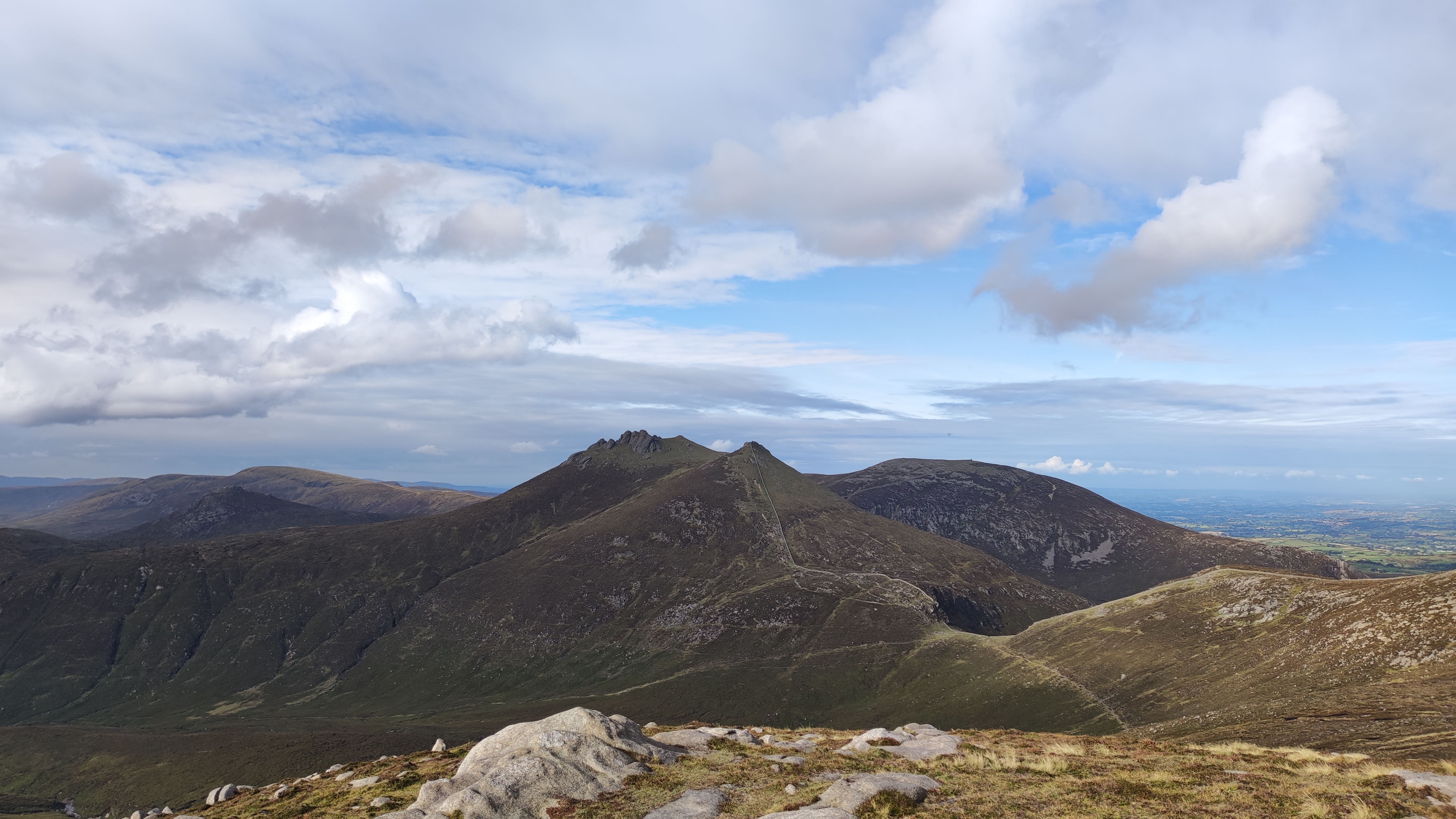
Commedagh
At the first large bridge the main trail crosses and heads up the left side of the river towards Donard but I took the right side into the trees and towards Commedagh and the trail gradually becomes a track. At a tumble down wall in the woods the track bears right and steepens considerably, showing evidence of bicycle tracks from what must be maniac MTB riders descending through the trees. At the edge of the trees an old wall is climbed by a rickety looking stile. Thankfully the gate was gone and I didn’t have to risk my neck climbing over it.
Out of the trees and I was on the side of the hill proper climbing along fairly clear tracks that headed straight up draining energy from my legs, leaving me breathless and my heart rate rocketing. The climb to the fairly flat Shan Slieve at just over 670m was brutal. It was approximately 2km with 400m of climbing and took me the best part of an hour. Climbing up this slope was a real shock. I knew the day was going to be hard but I didn’t really expect it to be that tough and definitely not so soon. I was seriously worried about my fitness and ability to continue the rest of the day. I’d only come 4km and it had taken me almost an hour and a half! Resting at the top and trying to bring my heart rate to something more reasonable it suddenly dawned on me to check the elevation on my GPS. It sounds stupid now but I had forgotten that I was climbing from sea level to that height of 670m and that this first 4km was over 50% of my total elevation gain for the whole day. As my heart rate slowly dropped below the red line and I sat enjoying the view out over Newcastle I began to feel better about the rest of the day.
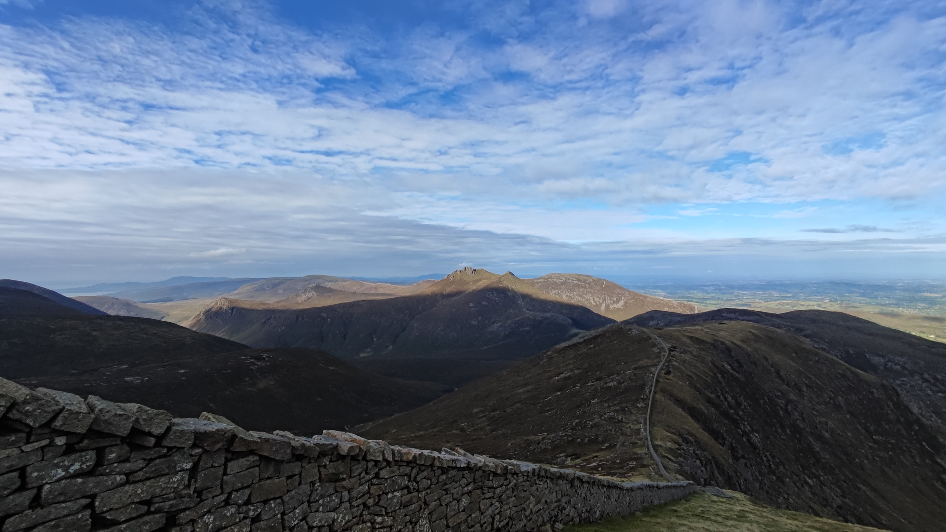
The approach from the flat top of Shan Slieve to Commedagh was amazing. It’s another 100m of elevation but on a much more gentle incline and along a narrow feeling ridge with views across to Donard on one side and deeper into the Mournes on the other. The ridge curves around gently before rising to the large dome of Commedagh and is known as the Pot of Pulgarve. The Glen River and the trail to Donard is clear to be seen and on such a still day I could hear walkers on this path as they talked to each other over the sound of the rushing river.
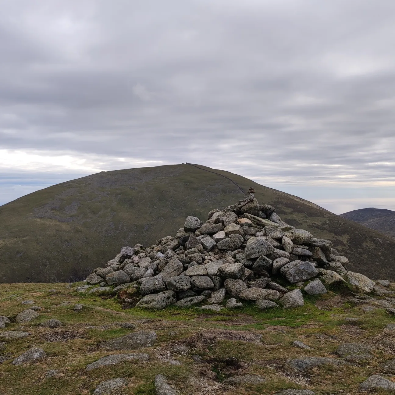
As you climb the side of the hill the large cairn (reportedly an ancient burial cairn) slowly appears on the top of Commedagh and I also got my first real view of The Mourne Wall and a clear view of the top of Donard across the col. Time for a proper rest and a chance to soak in the views.
Walking the Wall
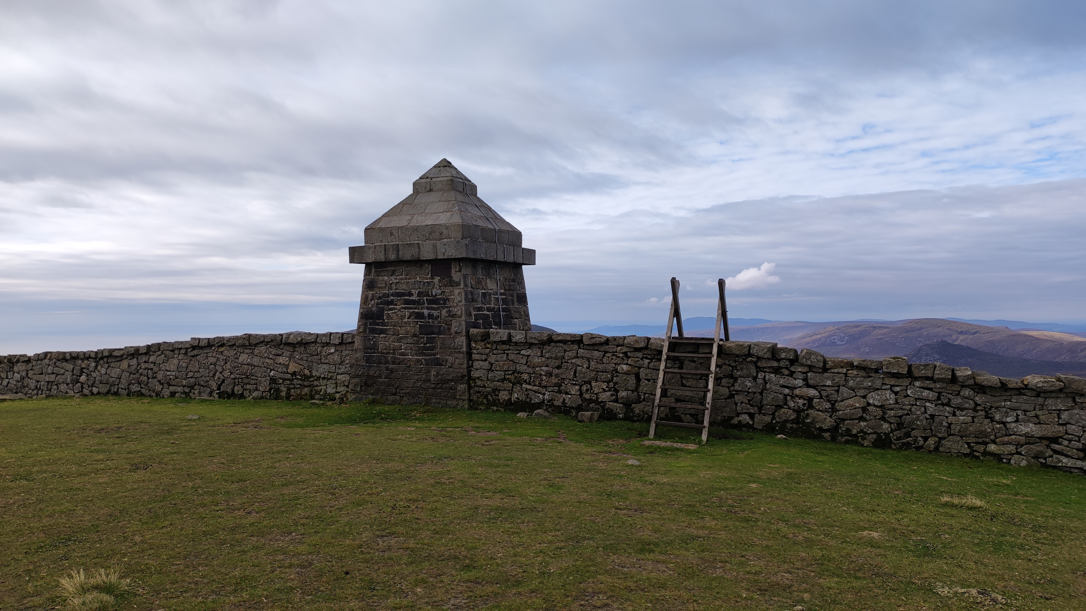
I’ve heard a lot about the Mourne Wall and seen plenty of photos of it but I wasn’t prepared for just how amazing it was in real life – it’s huge! I was aware of the length (31km) but wasn’t prepared for just how substantial it is. It’s 1.5m tall and almost 1m wide. It’s constructed from large square cut granite stones, crosses 15 of the highest summits in the area and took approximately 18 years to build from 1923! It’s mind boggling to be truthful.
The wall was now to be my handrail for the rest of my journey as far as Hare’s Gap. As I approached from the cairn on Commedagh there was a large crossing stile but seeing a group of walkers this side of the wall I decided not to cross and followed it along and off the steep side of Commedagh. Along the way I passed some amazing rock features above the Pot of Legawherry and the sun started to appear.
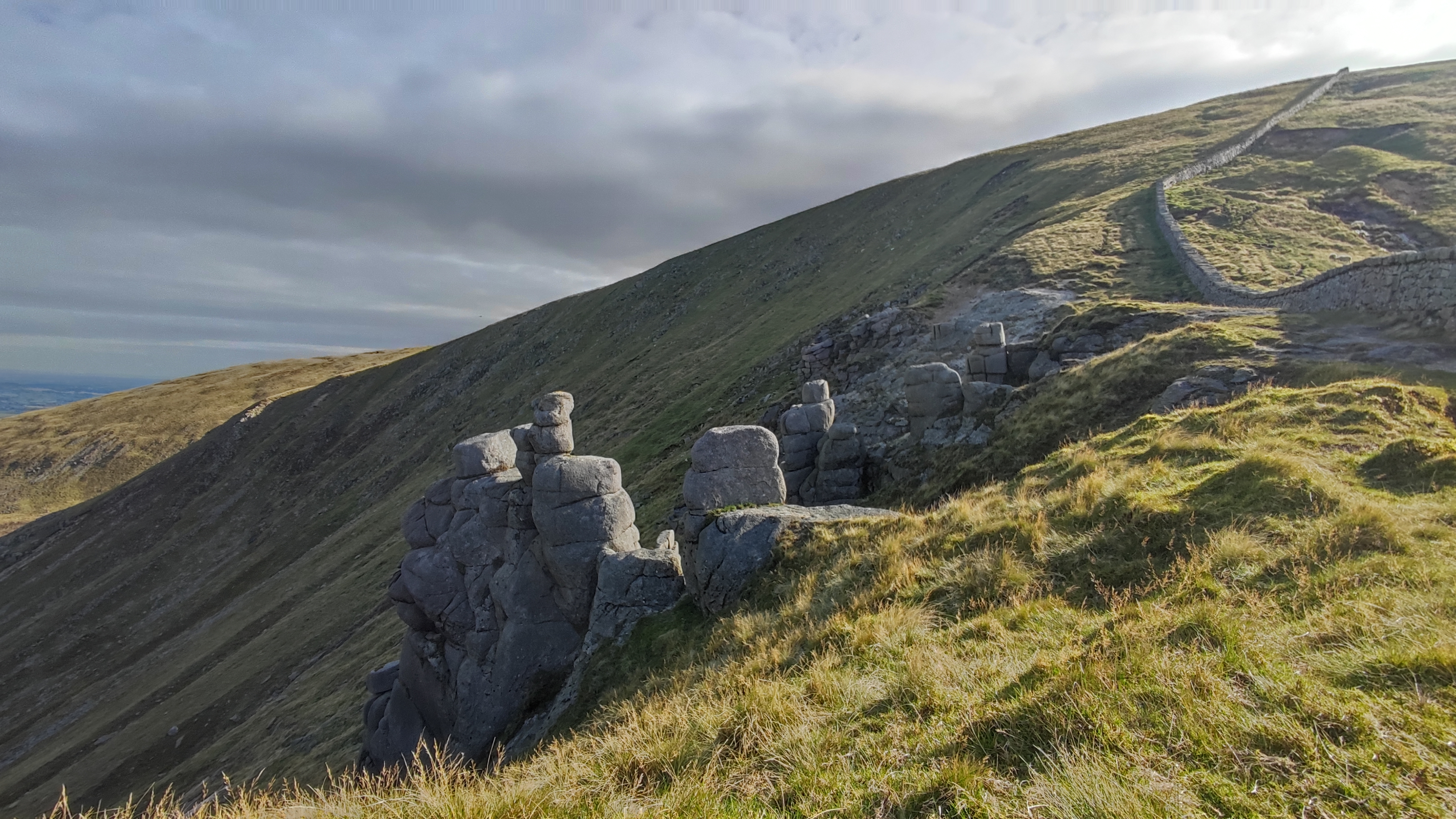
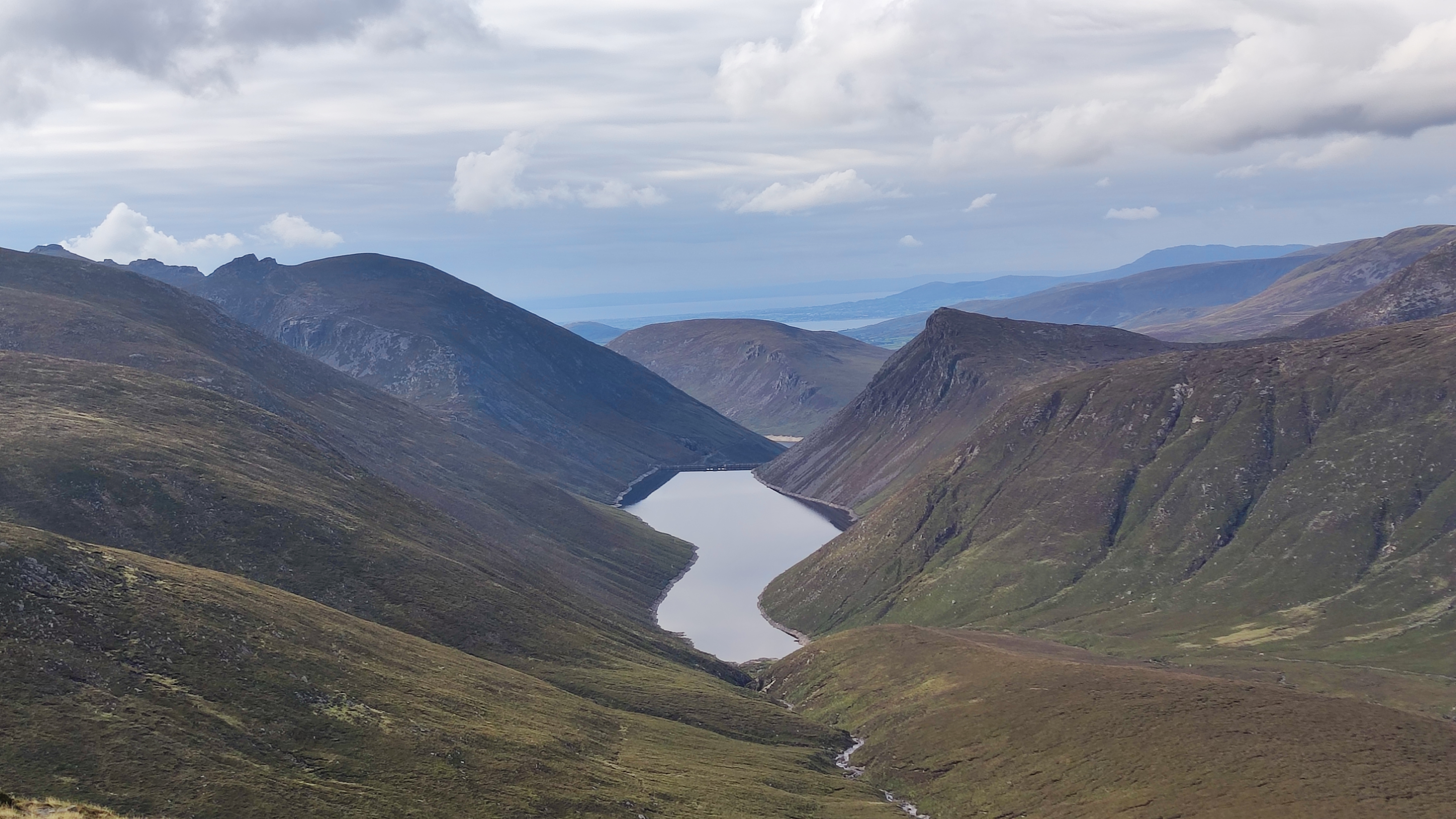
After the steep descent there was a short climb back up along the wall leading towards Slieve Corragh. Trying to locate the summit on the ground from the location on my GPS I realised that I should have crossed the wall back on Commedagh! With my toe wedged in a nook in the wall I was able to peer over and see the summit cairn about 30m away. Thankfully nobody was around to see my undignified scramble up, and over the 1.5m wall. It wasn’t pretty and that granite is unforgiving on bare skin! After all that, the summit cairn was simple. No burial site this time as it was a much smaller collection of stones to mark this 640m summit that seemed small with its bigger neighbours looming all around. The top of Corragh gave me my first views of the mirror calm Ben Crom Reservoir that I’ve seen many a time in a Gerry McVeigh YouTube video as well as a good impression of the rest of the circuit around to my destination above Hare’s Gap. Off in the distance was the hugely impressive and craggy summit tors of Slieve Bearnagh
Leaving Corragh the clear path undulated along the wall before dropping down into a small col. The ground remained dry but significantly eroded in sections with the odd damp spot but nothing like what I’m used to at home. Climbing back out of the col I came to the first of two summits – Slievenaglogh East Top (575m). This is a reasonably undistinguished rock outcrop just beside the wall. Unfortunately it was once again on the other side of the wall! Not being a purist I decided that at less than 10m away and on the same elevation I was close enough as it was obvious that if I crossed the wall I would need to cross back again for the main summit. Mentally I ticked the box and mosied on.
One last small push was to bring me to the top of the main summit of Slievenaglogh at 586m and marked by another substantial cairn where two other walkers were having a lunch break. The summit of Slievenaglogh is covered with extensive rocky areas which give the mountain its Irish name of Sliabh na gCloch ‘mountain of the stones/rocks’. In one of these rocky areas I got enough shelter from the slight breeze that had appeared to set up my stove for tea and a much deserved lunch break at what I figured was almost the halfway point. Sitting looking across at craggy Slieve Bearnagh I couldn’t imagine a better spot.
According to Mountainviews.ie my closest recorded summit is a small hill (219m) just 6.9km in a straight line from home. In fact I can see it from my front door. The hill is officially called Meenavally but locally it is known as The Steeple.
On the top of the hill there is a small, squat and pretty ugly tower built with stone and lime. There is a door in one wall and an internal winding staircase that brings you to a flat area with a low parapet. In the centre of the upper floor there is a round opening with a metal grate that allows vertical access from the ground floor, almost like a chimney.
Over the years there have been many gruesome rumours about the tower on the hill. Stories are told of satanic rites and devil worship including disappearing children and human sacrifice. None of these rumours are true but the origins of the tower are still interesting.
The townland is called Tircallen and from the 1600s the area was part of a larger estate of the same name created during the Plantation of Ulster. It was purchased by Sir Henry Stewart in 1789 and in the early 1800s he constructed the tower as an astronomical observatory which was very much in vogue with the gentry of Ireland at the time. Unfortunately, there are no surviving records of Sir Henry’s so it isn’t known what observations he made or what contribution this tower made to scientific research of the time.
The tower is also called The Steeple after the hill but is also known as Mullaghagarry Tower after the name of the forest woodland it is now located in. The forest is a commercial forest owned and operated by Coillte. It’s likely that the estate was acquired by the government’s Land Commission in the 1930s for redistribution to local tenant farmers which was the policy of the time. The tower, however has survived relatively unscathed.
I’ve been to the tower multiple times on foot and also by bike as we used to use the area for night time MTBing a few winters ago. I placed a geocache in the area in 2006 to mark the date of 06/06/06. In 2007 myself and a few other geocachers took part in a documentary on geocaching for RTE’s Nationwide programme. It’s the second location in the video below.
Although I’ve visited the tower many times I want to revisit all locations afresh for my Local 50 challenge so on Sunday I went back. I used a different access point than usual and my plan was to create a looped walk of approximately 9km. However, my maps are really out of date now and the hoped for track petered out on private farmland that I wasn’t happy venturing on to.
I attempted to work my way around through the trees on faint paths but not knowing the area too well I ended up back out on the main track and at that point decided to make it a simple there and back walk but still ended up with 6km. Rosie the dog was with me and despite some very heavy rain showers we had a very nice afternoon.
Not much photography on this walk but I did film and the results are linked below if you want to watch. Thankfully I seem to have solved the audio sync issue I had before.
Altnapaste is 364m high and located on the Eastern edge of the Bluestack Mountains just a few kilometres west of Ballybofey. It’s a hill I’ve had on my radar since I first started looking at my Local 50 peaks on Mountainviews.ie a couple of months ago. A number of cycling routes pass near Altnapaste and although it’s not that high it is fairly distinct.
At the time I climbed it there wasn’t a specific GPS track but there were a number of logs giving good descriptions and waypoints and I managed to create my own track quite easily.
The first section of the walk is along a farm/forestry access lane so there was a good wide area for parking at the start. The first few kilometres on the track gave me a good chance to warm up the legs before I turned off track and onto the rough grass/heather hillside along the edge of a small pine plantation.
The hillside soon turned steep and the going was pretty tough with no track and deep grass and heather. After a few hundred metres the ground eased off a little and continued climbing until I reached a fenceline that was easily crossed. With a bright clear day I was easily able to plot the route ahead and crossed a flatter area before hitting a grassy ramp that climbed between two sections of the hill. Although the ground steepened the grass made the going a lot easier to manage and I soon reached a second fenceline. I knew this one went all the way to the summit and that I was only a few hundred metres from the top.
The final climb was once again through steep, rough ground, heavily overgrown with knee deep heather before levelling off on a rocky flat summit with a short walk to the summit cairn. The views were fabulous in all directions, especially to the west where the sun was starting to set and appearing below ominous grey clouds but creating one hell of an atmosphere.
The breeze was bone chilling and relentless so I didn’t hang around too long before I started to retrace my steps and returned the way I’d ascended, this time enjoying the great views that were mostly behind me on the way up.
At the bottom of the hill I diverted into the pine plantation to have lunch and some peace and quiet. I’d brought my gas stove to heat water for a fresh cup of tea. This is a recent change for me and one of the best things I’ve started doing out walking this year. A fresh cup of tea beats a flask any day of the week and is more than worth the little bit of extra weight in the rucksack.
This spot turned out far nicer than I expected from my very brief glance on the way up. Once through the branches at the edge the space opened out nicely with lots of deadfall allowing loads of light in and enough space to feel surprisingly open for a plantation. It was so peaceful out of the wind and I could have stayed there for hours. I didn’t think my mind needed clearing but that half hour definitely did.
The last couple of kilometres, back along the lane again, were a perfect finish with great views again of the sun setting behind the main Bluestacks. What a cracker of a day!
The reason I have delayed so long in writing this post is that I also filmed the walk. I finally got around to editing the footage yesterday to be able to add it to this post. Link below as usual.
I’m struggling to get the audio to align with the video. It’s out of sync on the original, synced up fine in the app and then seems out of sync again once finalised. I’m not sure if it’s my camera, the app or me but it’s very frustrating! I may try a different app next time to see if that works better.
edit (29.12.21): I think I’ve now worked out how to correct the out of sync audio and keep it in sync during the finalisation process. At least the morning commute was useful for something 😆
Last Wednesday I decided to head west of Ballybofey and up into the outer reaches of the Bluestack Mountains. There are a lot of big walks there in my closest 50 summits but also some shorter ones for days like today when I’m short on time.
Cuillagh SE Top (369m)
There is so much choice in this area that it took me a long time to decide but this looked like a nice walk. The page on MountainViews also had a track to download. I initially thought it was about 5km and would take about an hour to an hour and a half but I had it mixed up with one of the many others I looked at!
There is a good parking spot close to a house that is literally in the middle of nowhere. A number of scrap cars are parked in a layby area with ample space to add another.
The first section of the walk heads along a farm lane passing through two gates before taking a left turn and heading straight uphill across the grazed grassland. Navigation is easy as you are basically heading straight for the summit over some rolling hilly sections. Ground underfoot was soggy but not too boggy. The area was heavily grazed and the very wary sheep had kept the heather and grass short which made the walking much easier.
I reached the top much quicker than expected. There is no cairn or summit marker and there were a number of potential high spots. I stood on them all but my favourite was the rocky outcrop on the far side of the fence. The views from here were more than worth the effort of climbing over the fence twice.
views southeast to the bluestacks
north with errigal and muckish in the far background
towards inishowen
summit selfie
Having wandered around for a while I headed back to the start by a slightly different route taking me across two other grazed but empty fields. On the way I spotted this lad crawling through the grass. Seems late in the year but I’m sure he knows what he’s at.
The final section before the track involved scrambling down into and back out of a surprisingly deep gully formed by a stream running off the hill.
At only just over 3km this was a very enjoyable walk with great views of the Bluestack Mountains and North towards the Derryveagh Mountains. Definitely worth a visit.
This was a short drive away which involved skirting around Cuillagh and approaching the summit through a windfarm. This area is full of windfarms. I’m pretty neutral about windfarms but this kind of proliferation feels wrong. It also makes for a pretty dull walk!
I managed to park at the wrong gate (full of over the top and intimidating signs) so had a 400m walk along the quiet road before entering the correct gate.
you shall not pass. wtf!
a bit friendlier
Heading in the main gate I simply followed the windfarm tracks. They quickly ascend the steep climb but after the first few hundred metres tend to dip down below the surface of the bog meaning the views are pretty non existent. By the time I reached the end of the track and the final couple of hundred metres of grassland to the summit I was sick of the sight and sound of the windmills.
The final approach is once again straightforward and typical mixture of eroded boggy hags, grass and heather of this area. Once again the summit was unmarked but had decent views for all its height. I couldn’t help but feel though that the landscape was so much more beautiful before they started building the hundreds of windmills that filled every direction.
errigal and muckish again
summit selfie with the least amount of windmills possible
The trip back to the car was simply the approach in reverse. However, I somehow managed to get disorientated and took a wrong turn. Coming back to the junction I’ve no idea how I missed this sign!
My original plan was to go for a 3rd nearby hill called Ballystrang but it was another windfarm and I couldn’t gather enough motivation for it. I’ve also decided that I would be better keeping these short, easier walks for the winter when I have an urge to get out but only have a short weather window.
I’d given over today to getting some chores done. A couple of household jobs I’d been putting off for a while and giving my MTB a good clean and lube as well as changing the seat. I’m planning to MTB at least once a week with the club group but needed to make sure the bike was in good shape.
I’d everything sorted by 4:30pm and with a lovely mild and bright afternoon I felt the need to get some fresh air and stretch my legs. Croaghan Hill was my target as it’s a decent effort, less than an hour and not too far from home.
croaghan hill
I’ve climbed Croaghan before and when I checked my records I was shocked to see it was almost 9 years ago!
a very young rosie at the summit trig nov 2012
The start location is up a very minor road off the main N15 close to Lifford. The road surface deteriorates considerably for the last 400m but it’s manageable with care. The suggested parking location is beside a field entrance gate where the verge widens enough to squeeze in a single car.
The route to the summit crosses a number of fields and fences requiring careful navigation of barbed wire and considerable flexibility. Once over the final fence the route goes through a section of scrub thick with brambles and gorse along the line of one more fence. Last time I went along the downhill side of the fence but this looked more overgrown now and I decided to go uphill today. This was a mistake as the downhill side quickly thinned out whereas I continued to work through knee high heather, brambles and gorse. Eventually I was able to cut left and make for the summit.
The top of the hill is an ancient hillfort and the unmapped trigpoint is built slap bang on top of what is believed to be a burial tomb. It’s believed to be the tomb of no lesser being than Ithe who was the uncle of Milesius, the first of the country’s legendary invaders. He was killed in the Battle of Mag Itha (Finn Valley), the first recorded battle in Ireland, against the Tuatha De Danaan and buried inside the Bronze age hill fort on top of Croaghan Hill. He was buried in the highest point in this area so that even in death people would still have to raise their heads to look at him. His tomb is known as the Foyde.
It’s also believed that one of the stones of nearby Beltany Stone Circle was sourced from Croaghan Hill and transported the 5km to Beltany.
For such a short walk (approximately 20min) and a modest height of 217m this hill has fantastic views in all directions. I could see across Strabane to Knockavoe where I was last week and further into the Sperrins, west to Barnes Gap and the Bluestack Mountains with the sun setting behind them, north west to Mongorry Hill sitting above Raphoe with Beltany Top and stone circle in between and finally north to Inishowen. The weather this evening was perfect for enjoying this beautiful view of my local area.
summit selfie
strabane, knockavoe and sperrins
mongorry hill and beltany top
bluestacks and the setting sun
On the way down I followed the surprisingly obvious track off the summit to the fenceline. I was able to cross easily and follow the fence back to the fields. The track also seemed to go left and down a different route but I didn’t want to waste time exploring as I had another plan in mind.
The path back downhill was much better but care was required as there’s only a thin layer of soil over rock and it was very slippery in sections. The last 20m was a jungle of brambles and gorse making me regret the thin leggings I was wearing.
On my last visit I managed to partly dislocate my left knee when crossing one of the fences (previously dislocated and weakened and still gives me problems). I was relieved to get across this hurdle and back to the car in one piece today. At just under 2km and 45min in total it was a great mini hike to cap the day.
My initial plan was to head straight home but with more time than expected I decided to make a slight diversion on the way home and tick another small hill off the list.
Fearns Hill is only 231m, a short walk from the road and the second closest hill to home on the MountainViews list.
Although it’s had a good few visits only one other member has written a log. Not having much daylight left I decided to follow his directions rather than trying to plot my own route. These directions brought me to a very minor road and a tiny parking spot at yet another field gate just 275m from the summit coordinates.
I climbed over the gate, which is part of a cattle holding pen and headed across the field following the GPS arrow and bringing back memories of my geocaching days. I soon encountered the field boundary with a single strand barbed wire fence and a second fence higher up. I soon discovered that the first fence was electrified as the mild tingle kicked up my fingers and into my lower arm so I decided it was prudent to duck under rather than step over!
The second fence sits atop an embankment with a dry ditch on the other side. The hill rounds off above this. It brought to mind a hillfort and looking at the OS map at home it’s marked as an ancient Rath.
The top of the hill is now a farmer’s field with a few nondescript humps, one of which is the highest point. Close by on an exposed rocky outcrop is the remains of what appears to be a small concrete building. It’s unclear what it was but it may have been a forerunner of the nearby communication masts.
watch altitude is pretty accurate
Just like Croaghan there are brilliant views despite the low elevation. These include a cracker view back towards Croaghan itself. However, I felt uncomfortably like I was on private property and didn’t want to hang around very long. I was back at the car less than 20min after leaving and home in time to make dinner.
I’m fairly rattling through the closest 50 hills but it’s misleading as most of them so far are short and easy and the closest to home. It will soon get more difficult and hopefully more interesting too.
Today started a bit weird by being interviewed live on our local radio station (Highland Radio). It’s National Road Safety Week and as our club had a member knocked off his bike last week and are now campaigning for a hard shoulder on that section of the road, it was decided to go on the radio to highlight the vulnerability of cyclists and try to get across why we ride the roads the way we do. As PRO this job fell to me! I was expecting a 10min conversation with the show host but it turned into about 25min and I was arguing with a local road haulier. It was way more than what I expected but it’s had a good reception with the club members and I’ve decided not to waste time on the expected comments after the interview. Link below if you are interested in listening. I start at 12min.
The main plan for today was to go walking and to take in 3 of the summits on my 50for50 list. To the east of Strabane there are 3 summits on the edge of the Sperrin Mountains range. Neither of them is particularly challenging or that long of a walk but combined they make a decent day out. The first of these is Knockavoe, sitting above Strabane itself. Its not that big a hill but it pretty much dominates the town and is visible on all approaches.
I’ve been up here a few times before and it’s a simple but steep walk along a farm access lane to within 100m of the summit, before crossing a gate and into the field where the trigpoint sits. This time I went slightly shorter. There’s a second lane further up the hill that connects with the road and is much closer to the top. I hadn’t really planned to go this way but I couldn’t get parked on the way up the road and ended up coming back down and decided to stop and start here instead.
The lane way starts right beside a house and despite being completely fenced off from the fields it kind of felt like I was in private property. Halfway along the two lanes meet and head for the top. It would be possible to construct a mini loop starting at the lower end and returning via the lane I used today and finishing along the tarmac road. Today though was just up and down.
This way isn’t a long walk (only 1.5km total) but surprisingly steep with no warm up and straight up from the car. There are fantastic 360° views from the top including the next target of the day. There is a particularly good view out over Strabane town and the way down is probably better than the climb as you get to see what was at your back earlier.
The second summit is a little bit higher but feels less as the starting point is almost as high as the summit of Knockavoe! There are two options but I decided for the slightly more mountainous SW of the summit. The initial approach is along a concrete access road to what looked like a Water Service pumping station having left my car optimistically parked on the junction verge of two minor roads. The concrete soon runs out and it’s a bit of a slog up a wet, boggy, overgrown track between two ancient fences and bordering a small forestry plantation. This track is a mixture of heather, grass and rushes, mostly knee height and hiding wet holes likely to swamp the top of your boots if you step wrong. The first 100m is particularly bad as it also seems to be a sheep highway on and off the hill. In fact I met one individual who had a tougher experience on the track than I hoped to have.
medic! 🚑
I wasn’t long on this path before I was wishing for my gaiters and walking poles and revising my earlier “easy walk” assessment.
The forecasted rain had started as a light drizzle shortly after leaving the car but steadily increased until it was raining quite heavily at the top and I was well in to the clouds. Visibility was very poor and views non existent. The nearby windfarm was clear to be heard and the appearance and disappearance of the turbines as the cloud thickened and thinned was quite eerie.
turbines in the mist
The actual summit was also quite difficult to find. The top of the hill is quite flat and there is no summit cairn or trigpoint. The poor visibility and lack of a proper GPS made this worse. I was reduced to using Google Maps and the phone GPS was struggling with the conditions. I eventually spotted an attempt to mark the summit but not where I figured the high point actually was. However, I was pretty wet and cold by now and decided to take it for what it was.
i honestly was trying to smile!
Looking on my mapping software at home I seemed to have wandered over the summit without realising it and the cairn is approximately 45m from the mapped coordinates but that’s good enough for me.
Return to the car was by the same boggy track and once again I cursed my lack of poles. I was muddy to the knees and soaked by the time I reached the end and with the cloud base sitting below 250m I decided to give the 3rd hill the skip for today. Instead I cranked up the heater and headed for home.
I’ve written already about finding it difficult to get motivated. In particular I’m finding it difficult to get motivated to go out cycling. In order to distract myself from this and maybe create a new desire to go cycling I’m doing two things. The first is to start back on the MTB with the Club group for the winter evenings. I used to do this a few years ago until the rest of the guys switched to Zwift instead. I need to do a little bit of TLC to my MTB and get over this head cold so it will probably be another week before I get organised for that.
My second plan is to get out and do some hillwalking again. Once I started cycling I pretty much stopped hillwalking but I’ve always enjoyed both the planning and execution of walking trips. I’ve also included some hillwalking challenges in my 50for50 list.
I was off Wednesday last week* as usual so decided to start straight away. I wanted something reasonably easy in terms of both planning and navigation to get me started so I chose a small enough hill called Bolaght Mountain (345m) South of Castlederg and approximately 40min drive from home.
I’m not a fan of “there and back” routes so devised a circular route based on the comments of other MountainViews members starting and finishing at the Sloughan Glen car park. Just under half the route was forest trails, a couple of kilometres was across the upland moorland and the rest on quiet country roads. The route was 14km plus the diversion to and from the actual summit of Bolaght giving a total of 15.5km.
Getting out of the car there is an immediate awareness of the local windmills. The steady breeze had the windfarm operating at full capacity and the noisy whoosh of the blades was very evident. Windmills are a constant companion on this route and if you aren’t a fan then this walk is definitely not for you!
Turning left out of the car park you then take the first road on the left marked as a dead end. It’s immediately uphill on a short, steep gradient through trees and high hedges. After a few hundred meters it levels off and opens out slightly to give views of the surrounding countryside. For the first 1-2km the road is tarred but soon turns into a gravel track but not too badly worn. One of the member comments on MV must have been here at the same time of year as he mentions the rowan trees and the berries. They were laden down for my visit too and lining both sides of the track.
Keep following the track past the entrances to the windfarm. Eventually you reach a farm gate. Cross this into a rougher track and follow this, above the river glen, over the bridge and into the forest by crossing a second gate. Don’t be tempted to take any of the windmill tracks as they will veer off in the wrong direction or dead end leaving you with rough, boggy ground to cross.
In the forest follow the forest roads and signs for Bin Mountain Windfarm.
On my visit the forest was misty and moody with the trees heavily draped with thick, green moss. I’d say this is a pretty wet location and I doubt if The Forestry Service will get much timber yield from here. Near the top of the hill make sure you veer left, still following the signs. The track takes a big dip and ahead it looks like a wall to be climbed!
Near the top I caught the flash of a deer darting into the trees. I’d say it had plenty of warning as I puffed my way uphill!
At the top of the ridge the track opens out of the forest and on to the open moorland mix of heather and coarse grass. You’re now in the windfarm proper, once you pass through one final gate, and suddenly Lough Lee appears in the hidden depression.
At the Eastern end of the lough the Ulster Way meets (or leaves depending on your perspective) the windfarm tracks. I started off following this but I should have headed straight for the summit at the signposted junction.
I was a few hundred metres along the Ulster Way trail before I realised my mistake and that I was moving away from the summit. I left the trail and headed straight up the ridge towards two small conifers. This was tough, knee-breaker ground and it took concentration and a good eye to avoid stepping in a hole hidden beneath the deep heather and grass. Thankfully the ground was well drained and pretty dry despite the recent rains. Once on the ridge it was a simple matter of heading West to the summit coordinates. The mapped summit is just beside a low, worn down fence and despite there being no markings it’s a fairly clear grassy patch, slightly raised above the surrounding heather. There’s a clear view down to Lough Lee and great views North over the countryside towards Castlederg.
summit pose
summit360
Standing at the summit and taking a bearing back to the Ulster Way trail I could see what looked for all the world like a road sign. It looked to be in the right location and was a perfect marker so I headed in that direction across the ridge. I was expecting this to be a real slog but once again the ground was much drier than expected and there were faint trails (probably from sheep) that made the going much easier. Before long I met the trail and chuckled to myself that the road sign was just that even if it was a bit the worse for wear!
The next few kilometres followed the Ulster Way to the alternative starting point at the head of a very minor rural road. The trail is reasonably well marked with a variety of very old, weathered and sometimes broken wooden posts and metal posts (about 25mm thick and knee high). The markers are every 100-200m but the metal posts are sometimes difficult to spot. I only had difficulty spotting the next one on one occasion where it looked like one marker post had disappeared completely. The next one was just about visible in the distance but took me a few minutes to spot. I don’t think this would be a great trail in poor visibility unless your navigation skills were particularly good. There seems to be recent quad activity along the trail which helps with route finding. So far it hasn’t torn up the ground too badly and hopefully it’s just local farmers getting access to the high ground and doesn’t deteriorate any further.
At the end of the Ulster Way the trail returns to tarmac roads and stays on them for the remaining 8km of the route. It’s not all bad though as this is a very sparsely populated area with only the occasional isolated house or farm. The roads are very minor rural roads and I only encountered one car the whole way and that was the postman. The scenery for the first few kilometres is really good with lovely views out over the valley below in the triangle between Castlederg, Drumquin and Newtownstewart. Clouds were low with incoming rain but on a clear day there should be a good view towards the highlands of Donegal and also the Sperrins.
The first section of road was very nicely lined on but sides with a fantastic display of fuchsia bushes. They’re a common sight on the North Coast, especially around Ballycastle and The Glens of Antrim but I haven’t seen them this far West like this before.
Lunch was had about a kilometer later in the shelter of a stand of conifers just past Slieveglass (in Irish: Green Hill) Windfarm. The trees gave a pleasant break from the strong, blustery breeze and allowed me to set up the gas stove and make a welcome cup of tea to accompany my sandwiches.
Heading off again I soon realised that the trees had protected me from more than just the wind. The cloud had closed in obliterating the view and bringing a steady, heavy drizzle that soon turned to proper rain. Hunkered down in a bit of a hollow for lunch I’d been blissfully unaware.
Although the area is now very sparsely populated there is ample evidence that it wasn’t always so. There are quite a number of old buildings. Some are almost ruins while others have been repurposed to shelter animals or to provide farm storage. There was even an old, abandoned schoolhouse. The inscription above the door was just about visible and suggested it was built in the mid 19th century. With so many buildings being abandoned it was nice to see one, close to the car park, being renovated and extended.
huge fireplace about all that’s left
schoolhouse
A few kilometres later the road turns back towards Sloughan Glen. The terrain changes again and the roads are now protected by high hedges and small wooded areas. Some of these areas were grazed by sheep or cattle but most seemed abandoned, another sign of the decline of the local population.
quiet roads
The final approach to the car park is along the banks of a small river. Its seems to flow from the main glen and is most likely the same river followed and crossed near the beginning of the walk. This area is the hunting grounds of a large adult grey heron who didn’t seem overly impressed to have me plodding through. He kept rising up and circling around. He was a bit worked up but giving me a great display.
15.5km brought me full circle and back to the car. However, I decided to go into the actual Sloughan Glen to walk the path and view the waterfall. The steep paths and many steps were a challenge for tired legs and achy knees but more than worth it. The area is an ASSI and absolutely beautiful. Two of the waterfalls were in good flow but I was surprised to see one of them dry despite the recent rain.
In total I finished with almost 17km and a thoroughly enjoyable day despite the constant rain for the second half. The road walking may not suit everyone but I enjoyed the variety of the route.