Tag Archives: 50for50

talking and hiking

Today started a bit weird by being interviewed live on our local radio station (Highland Radio). It’s National Road Safety Week and as our club had a member knocked off his bike last week and are now campaigning for a hard shoulder on that section of the road, it was decided to go on the radio to highlight the vulnerability of cyclists and try to get across why we ride the roads the way we do. As PRO this job fell to me! I was expecting a 10min conversation with the show host but it turned into about 25min and I was arguing with a local road haulier. It was way more than what I expected but it’s had a good reception with the club members and I’ve decided not to waste time on the expected comments after the interview. Link below if you are interested in listening. I start at 12min.

Highland Radio: 9 Til Noon – Wednesday 6th October

hike: knockavoe (296m)

The main plan for today was to go walking and to take in 3 of the summits on my 50for50 list. To the east of Strabane there are 3 summits on the edge of the Sperrin Mountains range. Neither of them is particularly challenging or that long of a walk but combined they make a decent day out. The first of these is Knockavoe, sitting above Strabane itself. Its not that big a hill but it pretty much dominates the town and is visible on all approaches.

I’ve been up here a few times before and it’s a simple but steep walk along a farm access lane to within 100m of the summit, before crossing a gate and into the field where the trigpoint sits. This time I went slightly shorter. There’s a second lane further up the hill that connects with the road and is much closer to the top. I hadn’t really planned to go this way but I couldn’t get parked on the way up the road and ended up coming back down and decided to stop and start here instead.

The lane way starts right beside a house and despite being completely fenced off from the fields it kind of felt like I was in private property. Halfway along the two lanes meet and head for the top. It would be possible to construct a mini loop starting at the lower end and returning via the lane I used today and finishing along the tarmac road. Today though was just up and down.

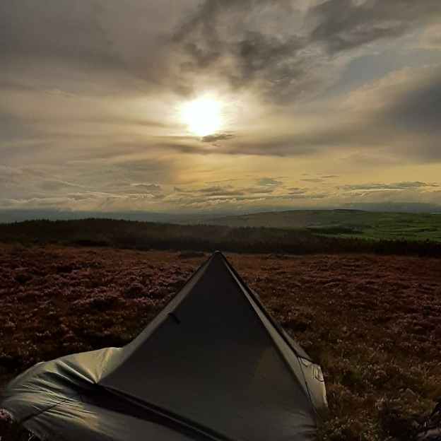
This way isn’t a long walk (only 1.5km total) but surprisingly steep with no warm up and straight up from the car. There are fantastic 360Β° views from the top including the next target of the day. There is a particularly good view out over Strabane town and the way down is probably better than the climb as you get to see what was at your back earlier.

summit selfie

strabane

summit 360

click here to view on strava

Knockavoe on Mountainviews.ie

hike: owenreagh hill (400m)

The second summit is a little bit higher but feels less as the starting point is almost as high as the summit of Knockavoe! There are two options but I decided for the slightly more mountainous SW of the summit. The initial approach is along a concrete access road to what looked like a Water Service pumping station having left my car optimistically parked on the junction verge of two minor roads. The concrete soon runs out and it’s a bit of a slog up a wet, boggy, overgrown track between two ancient fences and bordering a small forestry plantation. This track is a mixture of heather, grass and rushes, mostly knee height and hiding wet holes likely to swamp the top of your boots if you step wrong. The first 100m is particularly bad as it also seems to be a sheep highway on and off the hill. In fact I met one individual who had a tougher experience on the track than I hoped to have.

medic! πŸš‘

I wasn’t long on this path before I was wishing for my gaiters and walking poles and revising my earlier “easy walk” assessment.

The forecasted rain had started as a light drizzle shortly after leaving the car but steadily increased until it was raining quite heavily at the top and I was well in to the clouds. Visibility was very poor and views non existent. The nearby windfarm was clear to be heard and the appearance and disappearance of the turbines as the cloud thickened and thinned was quite eerie.

turbines in the mist

The actual summit was also quite difficult to find. The top of the hill is quite flat and there is no summit cairn or trigpoint. The poor visibility and lack of a proper GPS made this worse. I was reduced to using Google Maps and the phone GPS was struggling with the conditions. I eventually spotted an attempt to mark the summit but not where I figured the high point actually was. However, I was pretty wet and cold by now and decided to take it for what it was.

i honestly was trying to smile!

Looking on my mapping software at home I seemed to have wandered over the summit without realising it and the cairn is approximately 45m from the mapped coordinates but that’s good enough for me.

Return to the car was by the same boggy track and once again I cursed my lack of poles. I was muddy to the knees and soaked by the time I reached the end and with the cloud base sitting below 250m I decided to give the 3rd hill the skip for today. Instead I cranked up the heater and headed for home.

click here to view on strava

Owenreagh Hill on Mountainviews.ie

hike: bolaght mountain

I’ve written already about finding it difficult to get motivated. In particular I’m finding it difficult to get motivated to go out cycling. In order to distract myself from this and maybe create a new desire to go cycling I’m doing two things. The first is to start back on the MTB with the Club group for the winter evenings. I used to do this a few years ago until the rest of the guys switched to Zwift instead. I need to do a little bit of TLC to my MTB and get over this head cold so it will probably be another week before I get organised for that.

My second plan is to get out and do some hillwalking again. Once I started cycling I pretty much stopped hillwalking but I’ve always enjoyed both the planning and execution of walking trips. I’ve also included some hillwalking challenges in my 50for50 list.

I was off Wednesday last week* as usual so decided to start straight away. I wanted something reasonably easy in terms of both planning and navigation to get me started so I chose a small enough hill called Bolaght Mountain (345m) South of Castlederg and approximately 40min drive from home.

I’m not a fan of “there and back” routes so devised a circular route based on the comments of other MountainViews members starting and finishing at the Sloughan Glen car park. Just under half the route was forest trails, a couple of kilometres was across the upland moorland and the rest on quiet country roads. The route was 14km plus the diversion to and from the actual summit of Bolaght giving a total of 15.5km.

Getting out of the car there is an immediate awareness of the local windmills. The steady breeze had the windfarm operating at full capacity and the noisy whoosh of the blades was very evident. Windmills are a constant companion on this route and if you aren’t a fan then this walk is definitely not for you!

Turning left out of the car park you then take the first road on the left marked as a dead end. It’s immediately uphill on a short, steep gradient through trees and high hedges. After a few hundred meters it levels off and opens out slightly to give views of the surrounding countryside. For the first 1-2km the road is tarred but soon turns into a gravel track but not too badly worn. One of the member comments on MV must have been here at the same time of year as he mentions the rowan trees and the berries. They were laden down for my visit too and lining both sides of the track.

Keep following the track past the entrances to the windfarm. Eventually you reach a farm gate. Cross this into a rougher track and follow this, above the river glen, over the bridge and into the forest by crossing a second gate. Don’t be tempted to take any of the windmill tracks as they will veer off in the wrong direction or dead end leaving you with rough, boggy ground to cross.

In the forest follow the forest roads and signs for Bin Mountain Windfarm.

On my visit the forest was misty and moody with the trees heavily draped with thick, green moss. I’d say this is a pretty wet location and I doubt if The Forestry Service will get much timber yield from here. Near the top of the hill make sure you veer left, still following the signs. The track takes a big dip and ahead it looks like a wall to be climbed!

Near the top I caught the flash of a deer darting into the trees. I’d say it had plenty of warning as I puffed my way uphill!

At the top of the ridge the track opens out of the forest and on to the open moorland mix of heather and coarse grass. You’re now in the windfarm proper, once you pass through one final gate, and suddenly Lough Lee appears in the hidden depression.

At the Eastern end of the lough the Ulster Way meets (or leaves depending on your perspective) the windfarm tracks. I started off following this but I should have headed straight for the summit at the signposted junction.

I was a few hundred metres along the Ulster Way trail before I realised my mistake and that I was moving away from the summit. I left the trail and headed straight up the ridge towards two small conifers. This was tough, knee-breaker ground and it took concentration and a good eye to avoid stepping in a hole hidden beneath the deep heather and grass. Thankfully the ground was well drained and pretty dry despite the recent rains. Once on the ridge it was a simple matter of heading West to the summit coordinates. The mapped summit is just beside a low, worn down fence and despite there being no markings it’s a fairly clear grassy patch, slightly raised above the surrounding heather. There’s a clear view down to Lough Lee and great views North over the countryside towards Castlederg.

summit pose

summit 360

Standing at the summit and taking a bearing back to the Ulster Way trail I could see what looked for all the world like a road sign. It looked to be in the right location and was a perfect marker so I headed in that direction across the ridge. I was expecting this to be a real slog but once again the ground was much drier than expected and there were faint trails (probably from sheep) that made the going much easier. Before long I met the trail and chuckled to myself that the road sign was just that even if it was a bit the worse for wear!

The next few kilometres followed the Ulster Way to the alternative starting point at the head of a very minor rural road. The trail is reasonably well marked with a variety of very old, weathered and sometimes broken wooden posts and metal posts (about 25mm thick and knee high). The markers are every 100-200m but the metal posts are sometimes difficult to spot. I only had difficulty spotting the next one on one occasion where it looked like one marker post had disappeared completely. The next one was just about visible in the distance but took me a few minutes to spot. I don’t think this would be a great trail in poor visibility unless your navigation skills were particularly good. There seems to be recent quad activity along the trail which helps with route finding. So far it hasn’t torn up the ground too badly and hopefully it’s just local farmers getting access to the high ground and doesn’t deteriorate any further.

At the end of the Ulster Way the trail returns to tarmac roads and stays on them for the remaining 8km of the route. It’s not all bad though as this is a very sparsely populated area with only the occasional isolated house or farm. The roads are very minor rural roads and I only encountered one car the whole way and that was the postman. The scenery for the first few kilometres is really good with lovely views out over the valley below in the triangle between Castlederg, Drumquin and Newtownstewart. Clouds were low with incoming rain but on a clear day there should be a good view towards the highlands of Donegal and also the Sperrins.

The first section of road was very nicely lined on but sides with a fantastic display of fuchsia bushes. They’re a common sight on the North Coast, especially around Ballycastle and The Glens of Antrim but I haven’t seen them this far West like this before.

Lunch was had about a kilometer later in the shelter of a stand of conifers just past Slieveglass (in Irish: Green Hill) Windfarm. The trees gave a pleasant break from the strong, blustery breeze and allowed me to set up the gas stove and make a welcome cup of tea to accompany my sandwiches.

Heading off again I soon realised that the trees had protected me from more than just the wind. The cloud had closed in obliterating the view and bringing a steady, heavy drizzle that soon turned to proper rain. Hunkered down in a bit of a hollow for lunch I’d been blissfully unaware.

Although the area is now very sparsely populated there is ample evidence that it wasn’t always so. There are quite a number of old buildings. Some are almost ruins while others have been repurposed to shelter animals or to provide farm storage. There was even an old, abandoned schoolhouse. The inscription above the door was just about visible and suggested it was built in the mid 19th century. With so many buildings being abandoned it was nice to see one, close to the car park, being renovated and extended.

huge fireplace about all that’s left

schoolhouse

A few kilometres later the road turns back towards Sloughan Glen. The terrain changes again and the roads are now protected by high hedges and small wooded areas. Some of these areas were grazed by sheep or cattle but most seemed abandoned, another sign of the decline of the local population.

quiet roads

The final approach to the car park is along the banks of a small river. Its seems to flow from the main glen and is most likely the same river followed and crossed near the beginning of the walk. This area is the hunting grounds of a large adult grey heron who didn’t seem overly impressed to have me plodding through. He kept rising up and circling around. He was a bit worked up but giving me a great display.

15.5km brought me full circle and back to the car. However, I decided to go into the actual Sloughan Glen to walk the path and view the waterfall. The steep paths and many steps were a challenge for tired legs and achy knees but more than worth it. The area is an ASSI and absolutely beautiful. Two of the waterfalls were in good flow but I was surprised to see one of them dry despite the recent rain.

In total I finished with almost 17km and a thoroughly enjoyable day despite the constant rain for the second half. The road walking may not suit everyone but I enjoyed the variety of the route.

click here to view on strava

Bolaght Mountain on Mountainviews.ie

Link to my note

Link to my route for downloading

*walk date Wednesday 22nd September. Report started one week ago and delayed due to illness.

going wild

On Saturday night I finally went wild camping. The weather forecast was grim with heavy rain and a thunderstorm warning for the afternoon and early evening but with the worst of it to pass by 6pm I decided to plan for the best. Thankfully the forecast was right for a change and it dried up shortly after 6.

Taking my cue from a successful way to plan a bike ride I got all my gear sorted the day before and packed that morning. Taking advice from some of the YouTube wild campers I follow I took more than I thought I would need but despite being reasonably strict the volume of stuff still surprised me.

Part of my problem is that not all my gear packs efficiently. For example the cooking cup is smaller than the gas canister so they can’t be nested. Also the thermal cup took up more space than I expected and my sleeping bag is probably bigger than most modern bags.

I’d chosen a spot called Dooish Hill between Raphoe, St Johnston and Newtowncunningham. I’ve been there before and it has a great view and only a short 1km walk from the parking location in case things went disastrously wrong. It’s also one of the 50 nearest hills listed on Mountainviews.ie so starts the 50for50 ball rolling for me too.

The actual campsite was OK but far from ideal. The area of grassland I remember turned out to be quite boggy and mostly covered with low heather. This made for damp, soft ground and while heather is nice enough to lie on it doesn’t compress as easily as grass and made everything that little bit more awkward but still manageable.

the heather complicated the pitch of the tarp

nearby unmapped trigpoint pillar

I’d brought two stoves with me. My BSR gas stove I used previously on my hike up Bessy Bell and also a small wood burning firebox copy from Lixada. The plan was to use the wood burner to cook dinner, keep away any midges and provide a nice fire as it got dark. The gas stove was for the morning to make life easier. After the day of heavy rain I also decided to bring a small bag of dry tinder and sticks and a large birch branch I’d taken from my local woods a couple of months ago. I didn’t fancy hunting in the wet trees nearby and trying to start a fire with damp wood. I did process the wood on site though with my saw and knife to cut and split it and lit the fire using a fire steel rather than a lighter. It felt surprisingly satisfying to do it this way – very bushcrafty!

Dinner was kept simple too. I brought some chorizo sausage pieces and a pre cooked pack of multi grains. I just needed to boil a small amount of water and then reheat the whole lot in the frying pan for 5min. Dessert was a chocolate chip muffin. All was eaten while enjoying the views as the low clouds came and went.

Sunset came quickly with darkness pretty much complete shortly after 930. However, just before 9 I was treated to a flock of birds (swallows, swifts or martins, they all look and behave very similar!) that swooped in and spent 10 minutes showing off their aerial acrobatics as they dined on flies and other insects high above my head. Even once it was dark there was a surprising amount of light in the sky.

I read for a while by the light of my head torch and finally went to bed shortly after 1030. I slept reasonably well, waking about 1230 and again shortly after 3. I needed a pee at 3 so it took a while to settle again but I then managed to sleep until just after 6am. Not perfect but good enough and better than I expected for my first night out. Another tip from YouTube helped. I was wearing a thin thermal hat and this was big enough to pull down over my eyes and stop the early dawn from wakening me too early.

The early morning was chilly and unfortunately the view was gone as the hill was totally shrouded in a dense bank of low cloud. A breakfast bacon bap and tea was nice but could have been so much better with a view to enjoy.

lost in the mist

Packing up was quick and simple, somehow everything went back in easier this time and after a short damp walk back to the car I was home again shortly after 8am.

All in it was a really good and enjoyable first wildcamp. I’ll definitely go out again and with my first experience I have some small lessons to help make it better next time too.

50 for 50

It was my birthday last month and at 48 I am now slap bang in the middle age zone and also deep into mid-life crisis territory. One wrong step and I’ll be hunting for a girl half my age and driving fast cars that I can’t afford!

about as far as the budget will stretch!

This is the first birthday that I’ve really felt my age. I was happy at every milestone in my life but for some reason 50 feels much more ominous. Some of you who come here regularly will scoff but it feels old and I don’t like feeling old.

This topic came up on a recent trip to the barbers. She is almost exactly 10 years younger than me and while she isn’t dreading 40 she has a plan to mark it with 40 things for her 40th birthday. The conversation reminded me of personal challenges set by two friends (Eileen and Yvonne) to mark significant birthdays of their own. Inspired by these 3 ladies I have come up with my own list.

Some of these are things I’ve been thinking of for a while and some are things I’m planning to do over the next few years anyway. There are no rules and no particular order. I’ll do some together and sometimes one thing might count for more than one item on the list. I’m allowing myself until the end of 2023 so have just over 2 years but, if I don’t get them all done then no worries. The goal here is to have fun!

  • Give up social media for 1 month
  • Climb Mt Everest (walking elevation)
  • Sleep on a mountain top with no tent
  • Camp on a beach
  • Raise €5,000 for charity
  • Walk a marathon
  • Cycle the Ireland Way
  • Climb the Ulster County Tops
  • Climb the Ireland 4 Peaks
  • Midnight Skinny Dip
  • Read 5 Classic Novels
  • Gift 5 coffees to strangers
  • Carve an item from wood
  • Give flowers to 5 strangers
  • Drive the Wild Atlantic Way
  • Visit the 32 counties of Ireland
  • Take a photo of 5 strangers and get their stories
  • Run a 10K
  • Stay silent for 24hrs
  • Abseil off a cliff or tall building
  • Complete a multi day bikepacking trip
  • Complete a multi day backpacking trip
  • Take 5 photos that are worth framing
  • Learn to swim
  • Cycle from dusk to dawn
  • Kiss the Blarney Stone
  • Firewalk
  • Have acupuncture
  • Take 5 yoga lessons
  • Take 5 dance lessons
  • Volunteer for a day
  • Plant 5 trees
  • Grow a meal
  • Catch and cook a fish
  • Bake a cake
  • Visit Tory Island
  • Spend a night on Aranmore Island
  • Re-visit the Aran Islands
  • Visit Glasnevin cemetery
  • Visit the War Memorial Gardens
  • Make a pen pal
  • Send a message in a bottle
  • Make a time capsule
  • Donate blood
  • Make a memory box
  • Climb the closest 50 hills to home on MountainViews.ie
  • Go pony trekking
  • Go for a wild swim
  • Do a pier jump
  • Grow a tree from seed

Header image Β© Pixabay