Tag Archives: barnes gap

beating anxiety

Anxiety and dealing with it has been on my mind a lot recently. A recent event really annoyed me and then I read Reg Spittle’s book “Camino Sunrise”. I reviewed it a little while back but essentially he writes about walking the Camino and dealing with significant anxiety issues before and during the walk. He describes a lifetime of anxiety and how it affected his life, his interactions with others and how it prevented him taking part in many social events and activities.

His story really made me think. I’ve had a few issues with anxiety over the last number of years but thought it was a recent thing. However, a number of his memories made me look again at events when I was younger. I was always shy and socially awkward as a teenager and a young adult. I found it difficult to make friends (still do to a certain extent) and found new and unfamiliar people and events difficult to navigate. I would worry about what could or might happen, would be concerned about being unliked or doing something embarrassing that would leave me open to ridicule.

I vividly remember one event in my first year at college when I made arrangements to go to a student night club with a group. One of the girls was on my course and the others shared a house with her. We arranged for them to pick me up on the way as we were all walking and they passed my digs. I remember hiding in the house with the lights off, pretending not to hear them at the door and claiming the next day that I wasn’t feeling well and went to bed early. All of this was caused by an intense fear that I wouldn’t fit in with them.

Other small events come to mind over the years, usually to do with social events and you can imagine how difficult it was to start dating! I cringe now when I look back at the first few times I met girls that I liked but was frozen by a fear of rejection and humiliation.

In the last few years I’ve had episodes of anxiety linked to big events but also for surprisingly minor undertakings. I remember binning at least one Audax cycle due to a fear of not being able to complete the route and worry about getting stranded with no way home. In the last couple of weeks I had a similar experience that really annoyed me.

I’ve done a few short and reasonably easy hikes in the last year or so and I have been developing a hunger for more challenging mountain hikes again. I’ve rooted out all my old books and rediscovered a circuit of the Sruell Valley that goes into the heart of the Bluestack Mountains and includes the highest point along the way. I made plans and pencilled it in for one of my days off. I was really looking forward to this hike for the best part of a week and had everything lined up days in advance and even the weather looked good.

The day before this all changed. I started worrying about all the things that could go wrong. My fitness is shot to hell, I’m carrying 10kg more than I should and it’s been 10-15 years since I attempted a hike with this kind of challenge. I was worried about the remoteness of the walk and my total inexperience of an area I hadn’t walked in before.

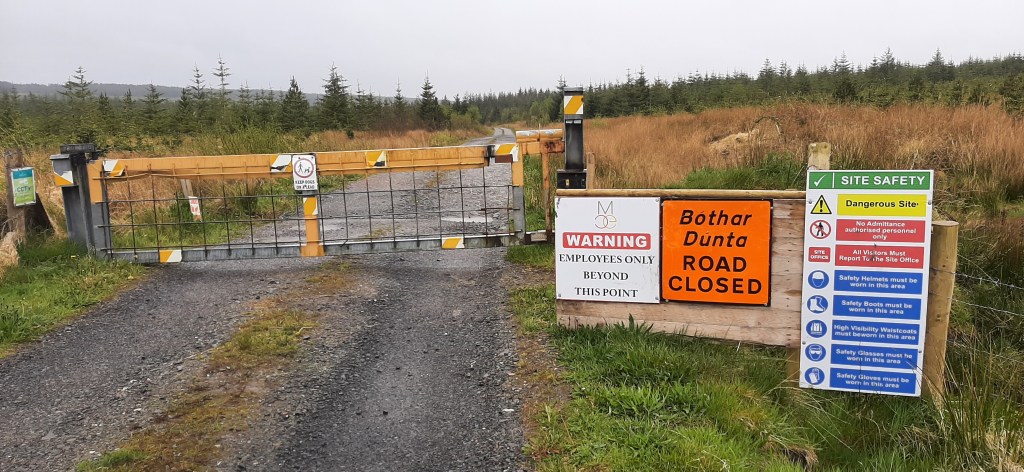
The morning of the hike I had an early appointment and I also had to be finished and back home by a certain time. My early morning anxiety manifested itself in an upset stomach and when the morning appointment went on longer than expected I was in a high state of anxiety. I somehow managed to convince myself to go anyway but the whole way to the starting point I was running through reasons to call it off. One of my ingenious excuses was to lie and say it was too cloudy as I could see a lowish cloud base on the drive over. By the time I arrived at the start this actually was the case. A weather system had creeped in that consisted of steady, heavy drizzle and a very thick, dark and low bank of cloud over the whole range. I couldn’t see anything above 200m and it was foolish to contemplate the hike in those conditions.

Within 10min of making the decision to abandon the hike and on my way home I could physically feel the anxiety lifting. It was like someone opened a valve and let it all drain out. The knots in my stomach that had been there all morning unravelled and I felt like I was floating with the decision made for me. It brought a sense of relief but also huge anger. I was furious and felt that I’d let the anxiety beat me and simply used the weather as an easy escape. I’m still not sure if I did or not but it certainly opened my eyes to how anxiety could and had prevented me from doing something I should have enjoyed. Reading Reg’s book a few days later really brought it all home to me but also gave me an urge to beat it.

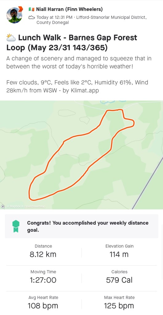
Within a day or so I’d come up with an alternative plan, to complete a different challenging hike of a similar level but one I had done before. In fact on the way home that first day I actually scouted out the start point for parking as I hadn’t been there for almost 15 years. On Sunday I did that hike.

barnesmore hike

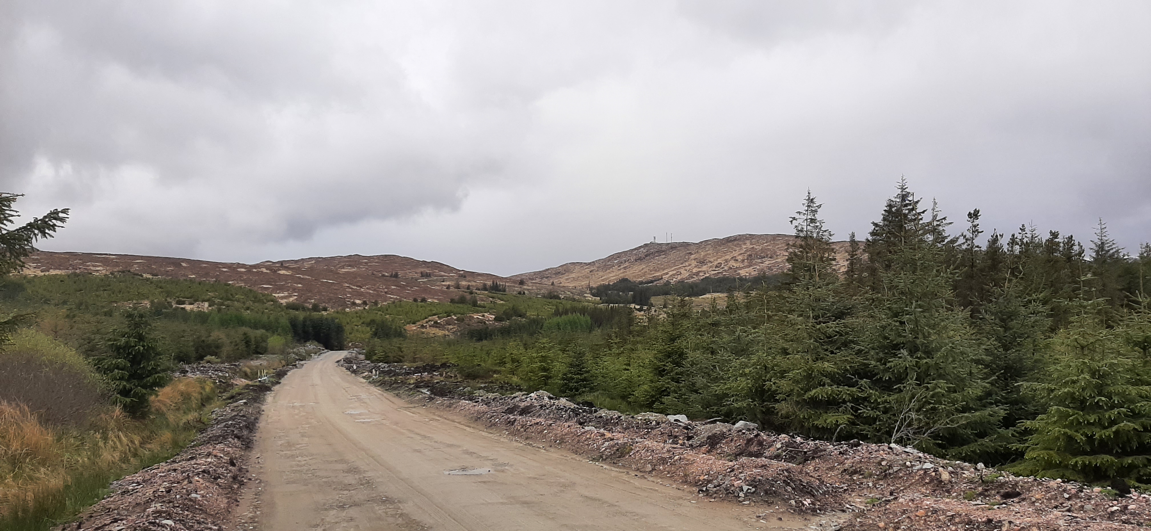
It’s a hike up Barnesmore Gap climbing Croaghonagh from the steep side and descending by a very steep gully. The first few kilometres follow the track of the decommissioned Donegal Railways line that ran from Stranorlar through the Gap to Donegal Town from 1889 to 1959. Walking this track there is ample evidence of the old railway. There are many of the original telegraph poles still standing, there are stone retaining walls on the hill to protect from landslides as well as stone culverts to divert streams under the tracks. The ground is clearly modified to provide a flat surface for the railway and the gravel used to grade the line is still visible on many sections. There is a subtle feel underfoot of the regular humps where the sleepers would have sat to support the rails.

barnes gap c.1890 © wikipedia

1959 photo shoot © flickr

After approximately 3.5km a convenient sheep trail provides a reasonably easy location to cross the old stone wall and get access to the hill. This is where the hard work begins. The next 45min was a slog through deep grass and heather, dry and brittle from the winter winds and the last week of dry weather. This is trackless terrain that is best traversed using vague sheep trails to avoid the worst of the boggy ground and hidden holes that could easily result in a broken leg or twisted ankle. Around and between craggy outcrops, crossing a couple of small streams and climbing a steep, grassy ramp eventually gives you your first clear view of the summit having climbed approximately 280m in 2km. The final push to the summit dips and climbs across a mixture of peat hags, boggy grassland and eventually a short steep climb up an enjoyable rocky outcrop.

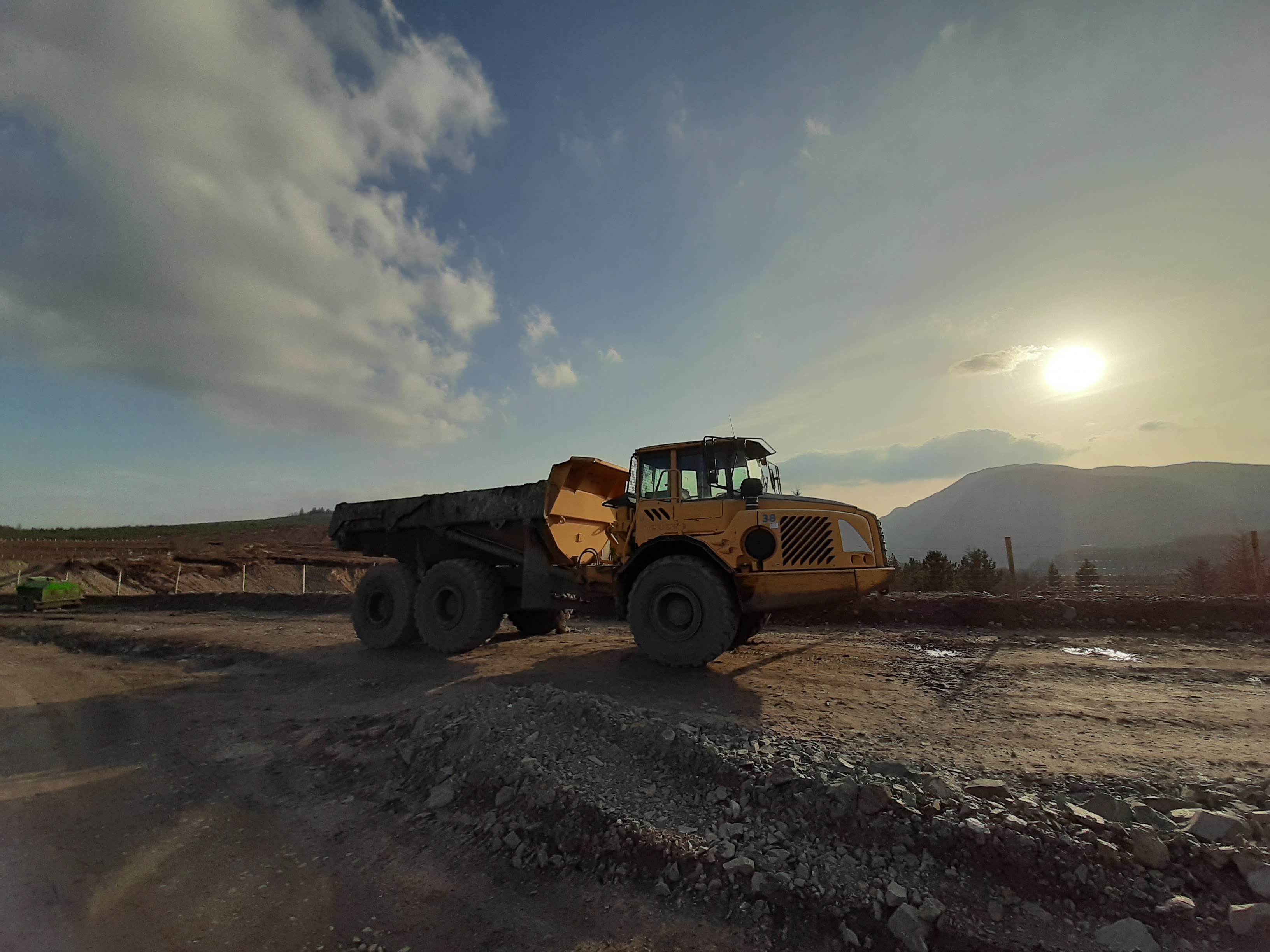
The rocky summit is spoiled by 3 masts surrounded by fences and support cables but the views are amazing. Despite the haze there were great views out over Lough Eske and Donegal Bay to St John’s Point and Slieve League just about visible in the far distance with the Dartry Mountains to the Southwest and Benwiskin and Benbulben clearly visible. Eastwards you are looking out over Lough Mourne and the bleak expanse of bogland stretching into Co. Tyrone as well as down the Finn Valley with the Sperrins clearly visible and the mountains of Inishowen in the far distance. Close by the craggy hulk of Croaghconnellagh looms just across Barnesmore Gap.

looking west

looking east

Lunch was had in the shelter of a large boulder with the wind thrumming through the mast cables sounding like a jet engine readying for take off. Out of the wind it was warm in the strong sunshine and I sat for almost 45min enjoying the view.

It’s possible to descend from the summit using the access track for the masts and forest tracks for approximately 5km. However, I opted for the much more direct option that follows a gully just below the summit that drops over the edge and the very steep drop back to the earlier approach trail. This is an incredibly steep and demanding descent that requires great care to choose the best line. Rushing here and a resulting trip or fall could have disastrous consequences. After the dry spell I probably had the best possible conditions for attempting it. Reaching the bottom my thighs and calves were throbbing with the effort and my knees were aching but looking back up I had an intense feeling of satisfaction for having done it.

The last 1.5km trace the original path in through the forest and back to the parking spot. A difficult, challenging but very rewarding hike.

interesting elevation profile

click here to view on strava

Update: 28th April

Video of my walk can be found here:

off-road adventure

I dropped my road bike off with the bike mechanic yesterday morning on my way to work. I had hoped to get it back early this morning and get a spin today but they’re very busy. He suggested it would be this evening before it would be ready so I had to make alternative plans.

It’s a while now (March last year) since I had a proper day out on the MTB. I’d spotted a great route a few weeks ago by a guy I follow on Strava and with a slight modification I soon had almost a 60km, mostly off road route to ride.

First though the bike needed some TLC. My poor MTB doesn’t get much more than very basic maintenance and performs way better than I deserve. However, before riding it today I had to spend some time scrubbing down and re-lubing the drive train and pumping up the tyres. After my hydration miscalculation on Sunday I also figured that taking my Camelbak would be a wise idea. Of course, it hasn’t been used in almost two years and needed a good sterilisation and clean too. By the time I’d everything prepared it was after 12 before I was in the car and off to the start.

The car park and start location is part way into Barnes Gap between Ballybofey and Donegal Town. The first 5K would be along this busy main road following part of my route from Sunday’s 100K. After this it turns off onto quieter side roads for another 5K to Leghowney Community Hall where it finally goes off road.

The route follows the first section of the Leghowney Loop Walk up through Meenadreen Windfarm. The first section of this is up a punishing climb for just over 2km with the gradient fluctuating between 10-14%. The windfarm has a 25km/hr speed limit and halfway up there was a speed display sign that seemed to take great delight in telling me I was going at 8km/hr.

This climb is up through mostly mature forestry and at the top opens out into the generic upland bog that is typical of this part of Donegal. It’s here were the turbines are located. There appeared to be two windfarms in total with the main one consisting of 25 turbines. Altogether there must have been 40 with a couple more locations visible on nearby hills. One thing about Donegal, there’s no shortage of wind!

Close to the first turbine there’s a very out of place bench that looks exactly like a memorial. I’m not sure of the meaning behind the plaque as I couldn’t see any signs of habitation but possibly any old ruins were cleared during the construction works?

The route through the windfarm is almost 9km in total along graded access roads. It varies from stiff climbs to sweeping descents. However, it’s hard to escape the feeling that you are riding through an industrial complex in the middle of nowhere. Once again I struggled to see the justification of the impact of windfarms while being hypocritical enough to enjoy the trails they provide!

donegal bay

Exiting the windfarm by a large gate with a pedestrian kissing gate, definitely not designed for bikes, I came out on the Laghey to Killeter road close to the border crossing called Kelly’s Bridge.

© Copyright Kenneth Allen from Geograph.ie

A short section of road brought me to the forest section of The Bannadoo Trail I walked at the end of April but heading in the opposite direction. Another 6km of undulating forest track before reaching Big Bridge.

from my april hike

Along this forest track I met a guy walking two beautiful beagle dogs. One of them decided to run along after me giving me a bit of a fright when I realised he was chasing me about 150m after I passed him. Not nice getting startled on these rough tracks, he could easily have caused me to slip and crash.

From Big Bridge it was back to climbing again. I’ve only ridden this section once before and from the opposite direction and I didn’t remember it being so long. It was almost 9km with the first 4km of that climbing, sometimes steep, and always with a track surface composed of rock dust that sucks the energy out of the legs. Along this section I was treated to the sight of a red deer bounding across the track from one forest section to the other before enjoying the final few kilometres downhill and back to road for a while again.

This 5km is the last significant section of road and took me past the start and finish of my Barnes Gap walk from a couple of weeks ago. It used to be possible to go up here and make an alternative route but with the ongoing construction I didn’t fancy the hassle today.

Turning after 5K took me on to a bog road that runs along the top of Lough Mourne which is the water source for most of the Finn Valley. This is a pretty barren location when the weather is against you but has a severe beauty on a warm, almost sunny day like today. Thankfully the wind wasn’t against me as it’s also ferociously exposed. The track is mostly used by tractors accessing the bog and as such the surface is incredibly rocky and rough, eroded further by water runoff. My ass took a real pounding* for 3km before I eventually dropped down to the head of the Lough and stopped to let tender bits recover.

*not intending to spend time in a maximum security prison, this is a phrase I didn’t ever expect to write!

Two short sections of road broken by a fast descent of a rough track at the back of the water treatment works brought me back to the forest and saw the last of the tarmac for the day. Along the first section of road I spotted a large buzzard hunting the abandoned grazing between the road and forest. He was hovering for ages but didn’t get to eat this time and eventually drifted off as if embarrassed to fail with me watching.

This last section of forest is familiar to me from two routes I’ve ridden a number of times. The first section crosses a steep ridge but normally I ride it in the opposite direction. It’s one of my favourite off road descents but today I had to ride up it. Close to the start of the climb there was a Cavan reg car randomly parked at the side of the track and a few hundred metres on I spotted a forest worker who obviously owned it. He was quite short and wearing a huge pair of wellies that looked way too big for him. These were literally his downfall as he tripped and took a tumble as he stepped to the grass verge to give me space to puff my way past. It was a real slow motion tumble and perfect roll and thankfully only his dignity was bruised. I was especially happy to see him getting up again as I didn’t fancy stopping and starting on that bugger of a climb. I was of course also happy to see that he wasn’t hurt!

Just before the steepest section the track cut off to the left and within 20m my Garmin was having a fit that I was off course. I looked at Google Maps to confirm I was right, there couldn’t be two tracks that close and going in the same direction, so I pushed on. The track did seem more overgrown than memory but it’s been a few years so I was happy enough. A few hundred metres later the track dead ended and I had to turn back. I’m sure that the Garmin would be sniggering if it could. The little Cavan man also got his revenge as I met him driving along the track as I made my way back to tackle the last couple hundred metres of 14% climb before taking the correct turn this time.

The advantage of doing this section the opposite way is that the tough uphill I normally struggle along now becomes a fast downhill although sadly broken by a gate halfway. It was along the flat section of the ridge that I had my most surreal experience on the bike a few years ago. I was pedalling along and swore I could hear music. Coming around the corner I met a beautiful black lab followed by a guy playing bagpipes! He walks the dog up here and brings the pipes to practice where he doesn’t bother the family or neighbours!

The final 10km was tough. It’s two sections of forest with a section of upland grazing in between. The forest is the usual graded track but the farmland section is back to a rocky lane. It’s a steep area rising and falling along the edge of the hill but generally climbing all the way. The farmland section is the steepest and the toughest with deep eroded sections exposing rocks big enough to stop me if hit the wrong way. By the time I reached the end of this all my contact points were sore and tender and crying out for a break.

Through this area there are a number of abandoned buildings. It was obviously a much more populated area over the last 100 years but completely abandoned now. It must have been a tough life eking out an existence up here, especially in harsh winters.

The final section of forest starts with a rapid downhill and one I’ve ridden many times. Knowing the terrain I let the bike go and aided by the open forest gate I got halfway up the next hill with momentum on my side. The next couple of kilometres are a series of rolling short, steep climbs with shorter descents gradually increasing the elevation each time. The track had changed to finer gravel and loose small stones making it very tiring on already tired legs. The strong breeze was also back in my face making it feel even harder again. I was very pleased to make it to the top of the last climb and took a few minutes to admire the views across the back of Barnes Gap, into the Bluestacks and catch my breath.

The last section is an exhilarating and very fast descent back to the road just 50m from the car park. This area gets a lot of rain so the steep track is badly rutted and eroded by constant run-off. It takes a careful eye and concentration to navigate safely especially as tired as I was. I made it safely and enjoyed this last blast of adrenaline before finishing.

Back at the car I was starving. I had a substantial late breakfast before leaving the house and had two bars along the way but I was out longer than expected and more than ready for food. Getting home I made a ham and cheese toasty that I may have swallowed whole! However, hydration was not a problem today.

click here to view on strava

I have my first vaccine appointment in the morning and I also have a 100km spin planned. I’m not sure about that now having read BgddyJim’s experiences post vaccine but as I still haven’t heard from the bike mechanic that decision may be made for me.

barnes gap loop

The weather forecast all week has been giving today to be pretty grim with wind and heavy rain all day. I had resigned myself to a day off in the house with possibly a short walk at some stage. However, the forecast was slightly wrong with the weather front breaking into two with a spell of pretty decent weather in between. As the morning progressed this looked more and more likely so I decided a change of scenery was in order and jumped in the car with Rosie and headed for Barnes Gap.

I was last up this track just over a year ago. Either I way underestimated how long it takes to construct a wind farm or Covid shut them down for ages. Construction is still very much ongoing with the hateful implications for the forest environment. The narrow, rocky, rutted and overgrown tracks that were really nice for walking and mountain biking have been replaced with construction sites, quarries and wide roads for construction vehicles.

In general I feel windfarms are a good thing. They will be part of the wider strategy to move away from oil dependency. I’m not a fan of the destruction involved in their construction though. With the amount of road building, use of plastics and heavy machinery it’s hard to see how they can offset the environmental cost of construction during their lifetime. I’m no expert though and also don’t have any alternative to propose. This site was also the location of the infamous moving bog last year.

no welcome but also nobody around on a sunday afternoon

Despite essentially walking through an active construction site I had the place entirely to myself this afternoon. I also had the pleasure of the wind in the trees, water running in the drains and streams as well as lots of birds singing.

After the dire forecast the weather was actually quite pleasant for most of the walk. During the last 20min the rain did arrive but I did expect it and had dressed appropriately. I did catch the start of the second band of wet and windy weather but just managed to miss the worst of it.

I had estimated the walk to be about 7km but it turned out to be 8km. As the weather has continued to keep me off the bike, despite my back gradually improving, I’ve managed a total of 35km this week. The weather is set to finally improve this week so I hope to get some short evening spins as well as a longer spin Wednesday. If I’m to get in a last minute 100k spin this day week I need to get myself back in shape!

click the image to view on strava

Header image by Pixabay from Pexels

barnes summit

Yesterday was such a good day with warm Spring sunshine for probably the first time this year that I decided not to waste it and threw my gear together in the afternoon and headed for Barnes Gap forest.

I fancied something a bit different from Friday’s spin and thought the trails up there would be good with a possible climb to the summit in the back of my mind.

I was aware of the works in the forest as there is a construction company installing a windfarm. On my last visit they were working between the summit and the quarry with minimal security at the quarry end but safe enough as the site shut down for the weekend. Big change now! The works have spread out along most of the main trails with massive sections quarried out to provide stone for the widening of the trails for increased access for construction vehicles. Most of the trails have changed from potholed gravel and stone to chunky hardcore and rock. Where the vehicles have been working and travelling the trails are a mixture of smooth and some rock but the newer sections are very rocky making the going particularly difficult.

On my loop I entered and left the forest twice each. Neither of the two entrances were signed but both exits were. If I’d seen the signs early on I probably wouldn’t have gone but by the time I saw the construction I was committed and decided to go ahead, especially as all the vehicles were parked up for the weekend. The only security was at the quarry end again but he couldn’t have cared less about me as he was standing chatting to someone.

Halfway round brought me to the summit trail. No windmills going in up there so the track was in good shape. I headed up with the option to retreat if my legs gave up on me. It’s a tough old climb this one at 2.2km and an average gradient of 7.4%. According to Strava it’s an elevation increase of 165m but I’ve no idea how that reflects on other climbs. All I know is that it’s pretty relentless with very little respite and a number of steep sections hitting 12-14% and I’m sure 20% on one of the final sections. The steepness is a real challenge but it’s the loose gravel on some of the steep sections and especially on the tight corners that are the most difficult. Pleased to say I made it to the top without having to stop and even managed a PB for my 3rd attempt taking 45secs off my previous time.

pb but still only 15th overall!

The views from the top were amazing. I’ve been up here a good few times, on foot as well as on the bike and this is definitely the best views I’ve had. I hung around for a few photos but the windchill was significant enough to speed me along.

The drop back down isn’t for the fainthearted either! The steep descents are slippy now with the loose gravel and the turns are tight enough to test. With images of A&E flashing through my head I kept on the brakes and took it fairly handy all the way down.

At the base I continued on through the construction site, stopping for photos before exiting out on to the main road. A short stretch of tarmac and back into the forest to loop around back to the car to give me almost 19km and 400m of climbing in 1hr 20min and a big smile on my face.

i went up the left hand one
click the image to view on strava

a traditional christmas

With my change of job this year has come an unplanned bonus, traditional Xmas opening hours and therefore traditional Xmas holidays. We worked right up until Xmas Eve with an early dart home and have been closed for the last 3 days giving me my first Boxing Day off and at home for 7 years and, according to Facebook Memories only my second in the last 10 years!

It has been a nice, family orientated Xmas this year with the last minute addition of Mum and Dad and my brother for dinner on Xmas Day, visiting a lot of the rest of my family on Boxing Day in Mum and Dad’s and obviously having 3 days to spend with my own family.

As a bonus I even managed to get out on the bike for a couple of hours this morning. A spin organised by MTB Donegal in Barnes Gap which turned out to be really enjoyable and gave me a fitness confidence boost that I wasn’t expecting after at least 2 weeks of inactivity and crap eating culminating in the excess that is also a traditional Xmas!

click the image to view on strava