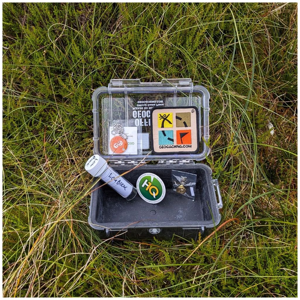
I don’t think I’ve ever written on this blog about geocaching before? It’s a hobby that I picked up in 2005 and it was my main pastime for a good few years. It suited my lifestyle perfectly at the time as it was just before Owen was born, work was very busy and it was a hobby that I could fit in with family life very easily. It was also a great way to spend more time outdoors as I had let that slide quite a lot at the time.
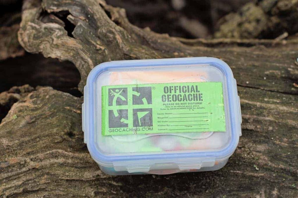
What is Geocaching? Well essentially a geocacher hides a container (sometimes large, sometimes small, often tiny), records the GPS coordinates and shares the location on Geocaching.com along with some information on the location and maybe a hint to help find it. Other geocachers then use this information to go and find the container and log their find on the website and in the physical logbook in the container.
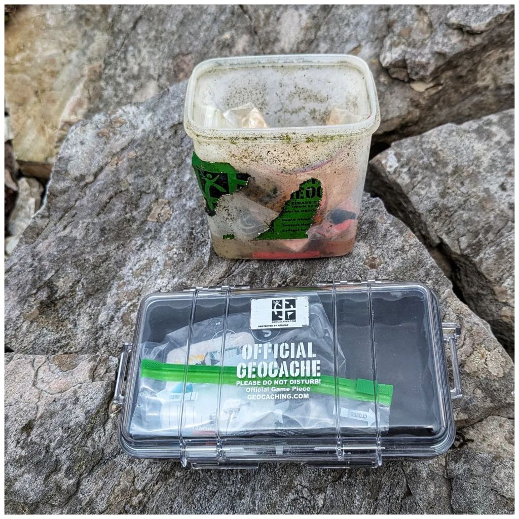
a variety of geocache containers a lot looklike this though
In 2007 I also became a geocaching reviewer which meant I checked listing submissions to make sure they were in suitable places and not contravening any of the placement guidelines. All checks were done virtually using digital maps and asking questions of the cache owner.
The geocaching community is incredibly diverse and mostly very friendly. Through my geocaching duties and attending social events I made many good friends and a lot of them I’m still in touch with today. However, as time moved on I retired as a reviewer (2017) and gradually geocached less and less as other hobbies (mostly cycling) took over. My last physical cache find was back in 2018 and since then I’ve only logged virtual caches on holidays in Prague and Venice to add them to my list of countries.
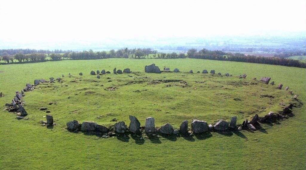
I have either removed or transferred ownership of most of my placed caches to other active geocachers but a small number still remain active under my account. One of these is at Beltany Stone Circle just outside Raphoe and a 10-15min drive from home.
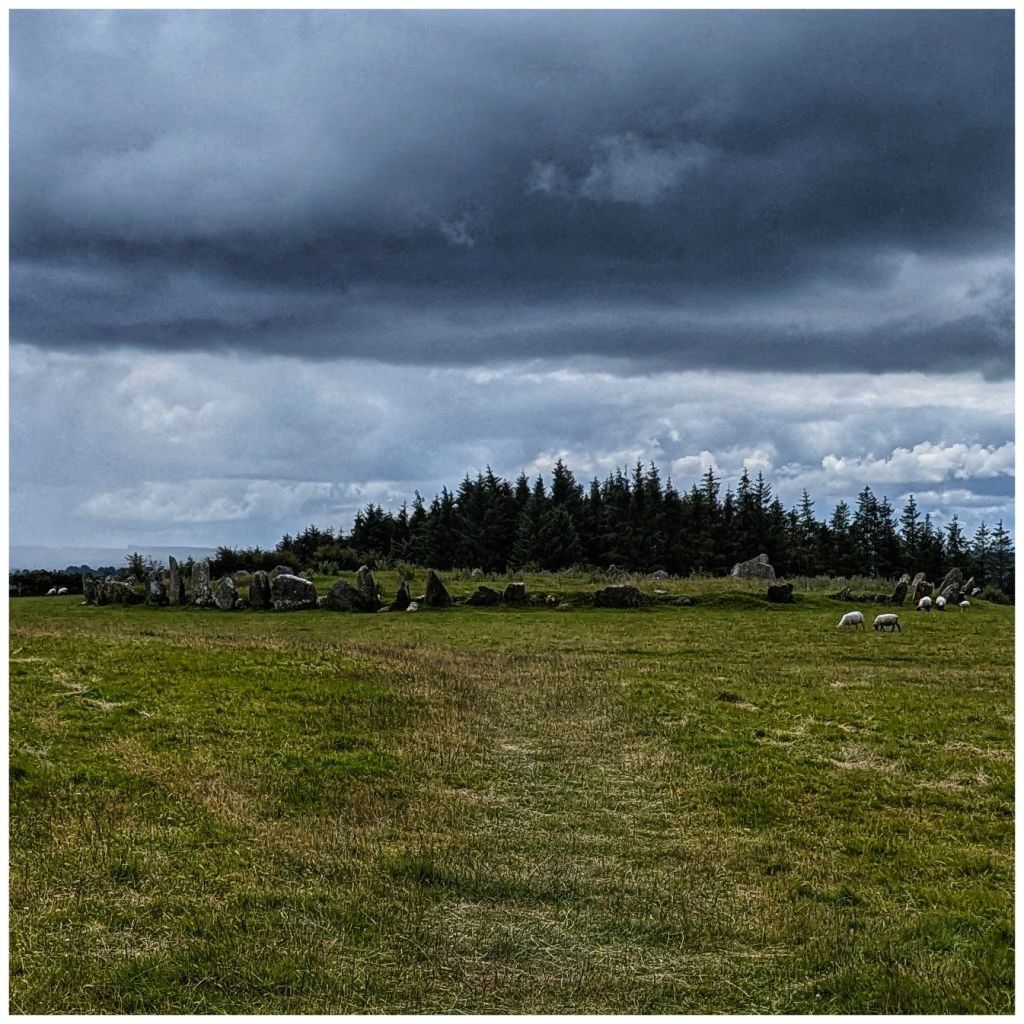
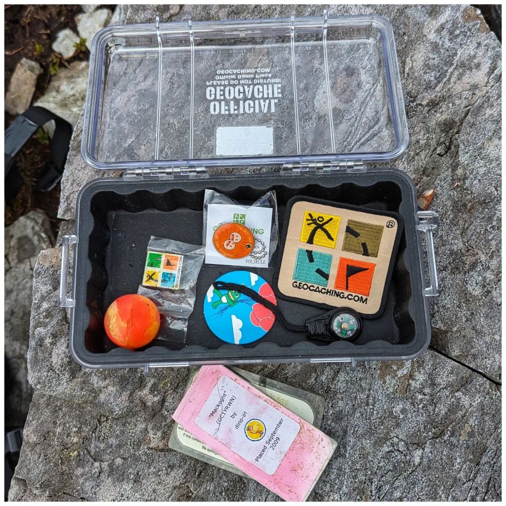
Beltany is a place I really enjoy and being so close to home this is one I hadn’t really thought of giving up. It’s not one that gets a huge amount of visitors due to it’s category of Multi-Cache so it rarely gives me any issues. In the last couple of weeks though it seems to have gone missing and I have been communicating over and back with a number of people that have been trying to find it. The weather for Sunday was a bit iffy so I dug out a box of old containers and Geocaching.com branded items and soon had a new one ready to go.
I had a very enjoyable walk up to the stone circle, replaced the cache and had a mooch around the neighbouring small stand of trees. I have a notion of bivvy camping up here at the stone circle to get the sunset and sunrise some time, getting in touch with my pagan side! I also found a couple of great spots in the small forested area for a hammock or maybe even a tent camp.
All the discussions over the last week or so must have re-ignited some dormant spark of interest as I also downloaded the geocaching app and had a quick look to see what new cache placements have been published in the last 8 years. Unsurprisingly there are a few!
My nearest one is a 5min drive from my house, on the edge of my home village and a spot I drive past at least once every day. On my way home from Raphoe I came this way, found it and logged my first geocache for 8 years. Took way longer to find it than it should have (it’s a very small hide but in the logical place, it just took a while for the penny to drop) but I put that down to being rusty.
I wouldn’t say I’m fully back into the hobby but it’s definitely sparked something again. There’s a whole new category of geocaches called Adventure Labs that sound interesting and there are two locally that I’ve highlighted to have a closer look at.
The geocaching theme continued into Monday. The weather forecast looked promising and significantly, even where showers were forecast, the cloud base was predicted to stay high. That has been a real issue for me this year! I initially had a hike in the Sperrins earmarked but instead decided to head for the Derryveagh Mountains.
I have a series of caches on two summits beside Errigal and a third at Lough Altan that are designed to be a great hike if done together. I did have one on Errigal as well but someone agreed to adopt it a while ago. All three of these caches were in need of some TLC and coincidentally I had 3 more containers left and enough Geocaching.com stuff to stock them. So my new plan was to hike the route, skipping Errigal and replace them all. This turned out to be a great decision!
9.8km with 605m of climbing
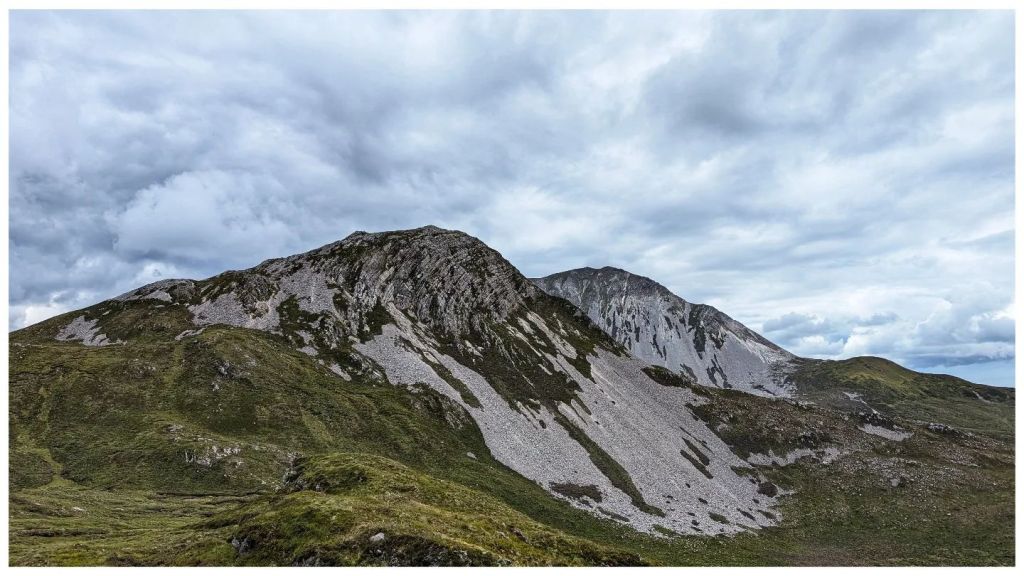
I started at the Errigal car park and followed the new path until I reached the cairn where the climb up Errigal proper starts. Here I diverted right and followed the faint track up the steep and rocky side of Mackoght (555m) which is also known as “little Errigal” or “Errigal’s little brother“.
in 100m, at the cairn, turn tight
Mackoght is a really enjoyable climb. In many ways I prefer this climb to Errigal. It’s a really satisfying mix of short grass, heather and broken rock. The summit itself is fantastically rocky with a really nice marker cairn and in my opinion the best view around of Errigal’s twin peaks.
reverse view over lough altan with the aghlas behind and muckish in the distance
I spent well over an hour on the summit of Mackoght replacing the cache container, having lunch, flying my drone and soaking in the views. The weather was perfect, lots of sunny spells and hardly any wind, a stark contrast to my last Irish mountain experience! Best of all I had it all to myself while there was a steady parade up to the summit of Errigal as the good weather drew people in. Sitting on Mackoght I could occasionally hear voices carrying across while I sat in splendid isolation.
The publication date of the cache on Mackoght is 2010 but it was part of the original multi stage cache placed in 2006. That box has been up there for 18 years! The logbook was the real surprise. It’s the 2010* logbook and was still in good shape, good enough to keep using. I guess the box did a good job all things considered!
old cache, new cache still in good shape after 14 years restocked and ready to go
*I made a new logbook in September 2009 but wasn’t able to get it in place until July 2010 thanks to some help from a group of geocaching friends.
Leaving Mackoght it was a steady drop to the damp col between Mackoght and Breaghy. This descent required careful route selection to avoid the many rocky outcrops on this side of the summit that make it so impressive looking from the top of Breaghy.
little brother with big brother behind
The col wasn’t as damp as it looked from above and I was soon picking my way back up towards the top of Breaghy (392m). Some confusion set in here as there are a number of rocky outcrops. The summit always felt like it should be closer and somehow even OSI have managed to mark the wrong one as the actual summit!
actual summit with a marker cairn marked by the red circle
Anyway, after enjoying the brilliant views out over Lough Altan and towards the Aghlas I found the cache container (half full of water and contents thoroughly waterlogged) and replaced it with the brand new box and logbook.
lough altan and aghla more, breaghy summit off to the left
The final descent from Breaghy to Lough Altan was “fun“! Instead of the longer and more gentle route I decided to take the steeper, direct route. Halfway down, scratched to bits by heather and with a bum wet from sliding numerous times, I realised it wasn’t a great idea and contoured around to a much more sensible and easier descent and was soon crossing the stones on the river just before the ruined tower.
altan farm from partway down breaghy
Here I met the first people I’d seen since leaving the Errigal footpath. A Mum and Dad and 3 teenagers were just heading back to the road. They were friendly but not chatty and I did wonder if they were geocachers. I wouldn’t imagine that many people make the effort to walk out to here and they didn’t really look like hikers if that makes any sense? I haven’t had any logs on that cache yet so they probably weren’t.
As I was now alone I headed to the cache location, retrieved and replaced it. The original container was a large vitamin bottle in a hole between rocks. The issue here is that the hole is deeper than I originally thought. The first container from 2006 disappeared into the bowels of the earth as it was too small and this one replaced it in 2010. Even still this one required the full length of my arm to retrieve which wouldn’t be pleasant on a wet day! So, the replacement is much larger and is attached to a hidden external tent peg via a length of paracord that should make it simple to retrieve yet still unlikely to be discovered accidentally.
I took a while here on the edge of the lough to enjoy the view and take some photos but with time marching on I couldn’t sit too long and began the climb out along the boggy track. I was last here in August 22 and back then the track was horrible with large sections flooded with deep boggy holes. Thankfully it has dried out a lot since then and only one or two spots caused me any concerns.
neighbours at the back door compulsory photo of the tree through the front window with the lough in the background altan farm and the aghlas from the track out
I arrived back at the Errigal car park approximately 5.5 hours after starting with 9.8km hiked and 605m of climbing. It should have been quicker but I spent a lot of time enjoying the views and it was time well spent. This was the most enjoyable hike I’ve done for a long time and part of that was the good feeling from getting these caches back to the standard that the locations deserve.
I’m not sure how far my renewed geocaching interest will take me but it’s a start anyway and totally unexpected…
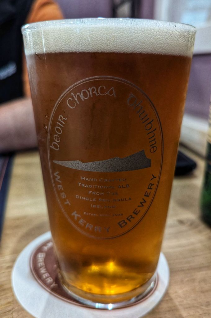
Friday evening was spent meeting Martin and a few others from the Galtee Walking Club I’d met before. We went for something to eat in a pub up the street having missed the cutoff in the South Pole. Long story but it was Martin’s fault 😉
Turned out well anyway as I had one of the best fish and chips I’ve had for a long time as well as a lovely pint of local golden ale Béal Bán
Friday night we spent in the car park at the starting point of the challenge hike. It’s the first time I slept in Catriona’s car and it was surprisingly roomy and comfortable. Only problem is dawn comes early just after 4am and there’s no escaping it in a car.
Our plan was to skip the bus transfer from Annascaul and start at 6am and be approx 1hr ahead of the crowds. Also giving us an extra hour on the cutoff, just in case…
Wakening up it was obvious that the weather forecast was accurate. Low cloud was hanging over the tops and partway down into the valleys. We still had a great view out to sea but only had partial views of what I think was Great Blasket Island.
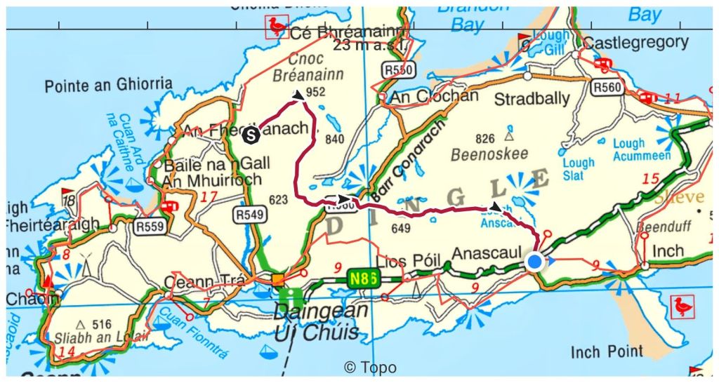
Starting from the car park we followed a rough track before turning off onto the grassy and sometimes rocky path that heads straight up to the summit of Mount Brandon. At 952m Brandon is the 3rd highest mountain in Ireland. It’s named after St. Brendan and on the summit there is a stone building (Sáipéilín Bréanainn) believed to have been used by him. The route we followed to the summit is part of a Pilgrimage Route (Cosán na Naomh – The Saint’s Road) and is clearly marked by small white posts and large metal crosses marked with numbers that I think denoted stations of the cross.
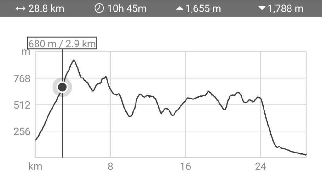
The weather forecast was for low cloud which was correct. It also predicted pretty windy conditions on the tops (30km/h or 19mph) and light rain for most of the day with more prolonged rain for the late afternoon. Well it was worse than that. We were getting rain spots from the car park and at 1km in the rain coat came out and stayed on for the rest of the day. After a further 0.5km we crossed 400m and into the clouds and the rain started properly. We weren’t to escape the clouds for the rest of the hike.
As you can see the first 4km is pretty full on. From the car park at 170m you climb almost 800m to the summit of Mount Brandon at 952m. This was the part of the hike that I was most concerned about. My fitness is far off what I would have liked for this event, I’m carrying about 13kg in excess weight and I had Covid about 4 weeks ago that left me breathless up until about a week ago. Climbing Brandon definitely challenged me, I struggled with my breathing but kept it steady and managed to keep my heart rate relatively steady without red-lining.
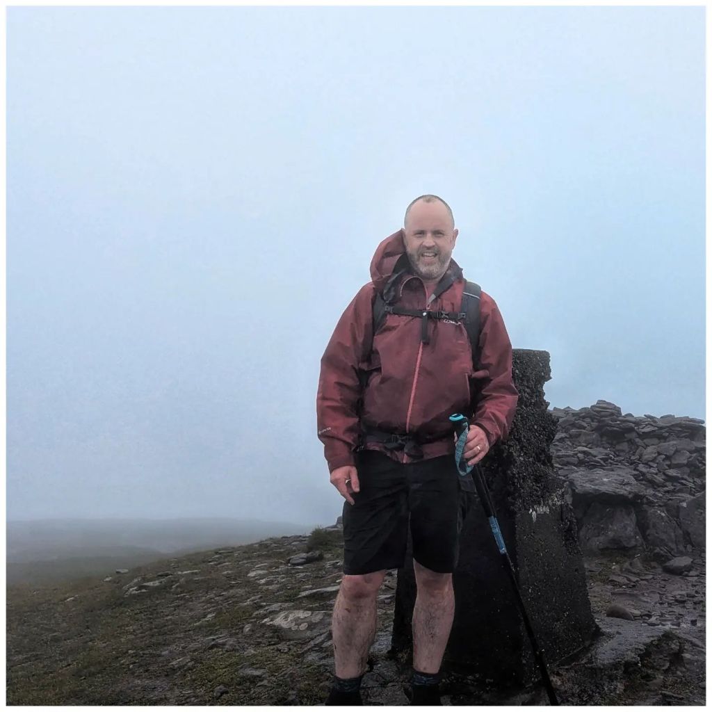
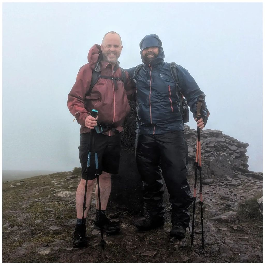
The last couple of hundred metres to the summit was pretty rough. The rain was pretty constant and by now the wind had really picked up driving the rain hard. The rain stopped briefly just before the summit but the wind was very strong and it definitely wasn’t a place to hang around. We got some shelter in the lee of the summit cross before a couple of summit photos, a very quick chat with a couple of other early starters and headed on. It was shocking how cold it was in that wind and my hands were painful as we headed off along the ridge.
i think that’s sáipéilín bréanainn behind the trig but it wasn’t a day for sightseeing!
Leaving the summit we had a long and soggy drop down that was a relief for the legs before picking up a track. Cloud cover reduced visibility to 30-50m and the wind was blowing very strong, once again driving the rain into us. At times I could see Martin ahead of me walking at an angle as he leaned into the wind to stay upright
This was a lonely section with no possibility to talk, no views and just your own voice in your head. On days like this it’s hard to stay positive.
come for the views they said!
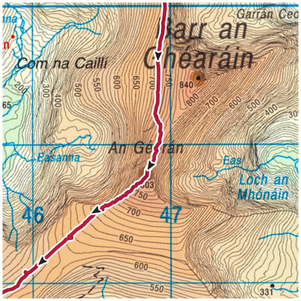
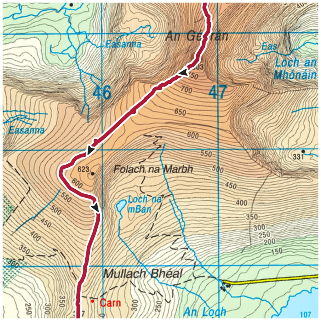
In a brief stop Martin warned me that we were approaching the ridge proper. This is a section called An Géarán and is a rocky, sharp and exposed ridge. Apparently the views down into both valleys are amazing but not today!
Crossing the ridge there was a real sense of a steep drop to both sides even with the thick cloud cover. Thankfully we were able to cross on the leeward side and stayed out of the wind. I’m not sure we would have been able to cross safely otherwise.
look at those contour lines!
On the approach to Brandon summit and heading across this ridge there was the very real feeling that there were a world of fantastic views that were hidden by the clouds. For this reason alone I’m very sure I’ll be back to walk this route again.
Leaving An Géarán we steadily dropped elevation along a fenceline and across boggy terrain that was oozing water everywhere. There were a number of tricky areas that were very boggy and verging on small streams that required a bit of thought. However, as we dropped down here the rain and wind eased a bit and we were finally able to have a proper conversation for the first time in over an hour.
I think it was around here (possibly earlier?) that Martin first mentioned the possibility of finishing early at the halfway point on The Connor Pass. I was glad to hear him voice what I’d been thinking in my head already. What was always going to be a tough walk was becoming even more difficult due to the weather. Although we were in a sheltered area now we would soon be a lot more exposed again as we climbed higher. I was pretty sure that I wouldn’t be finishing today.
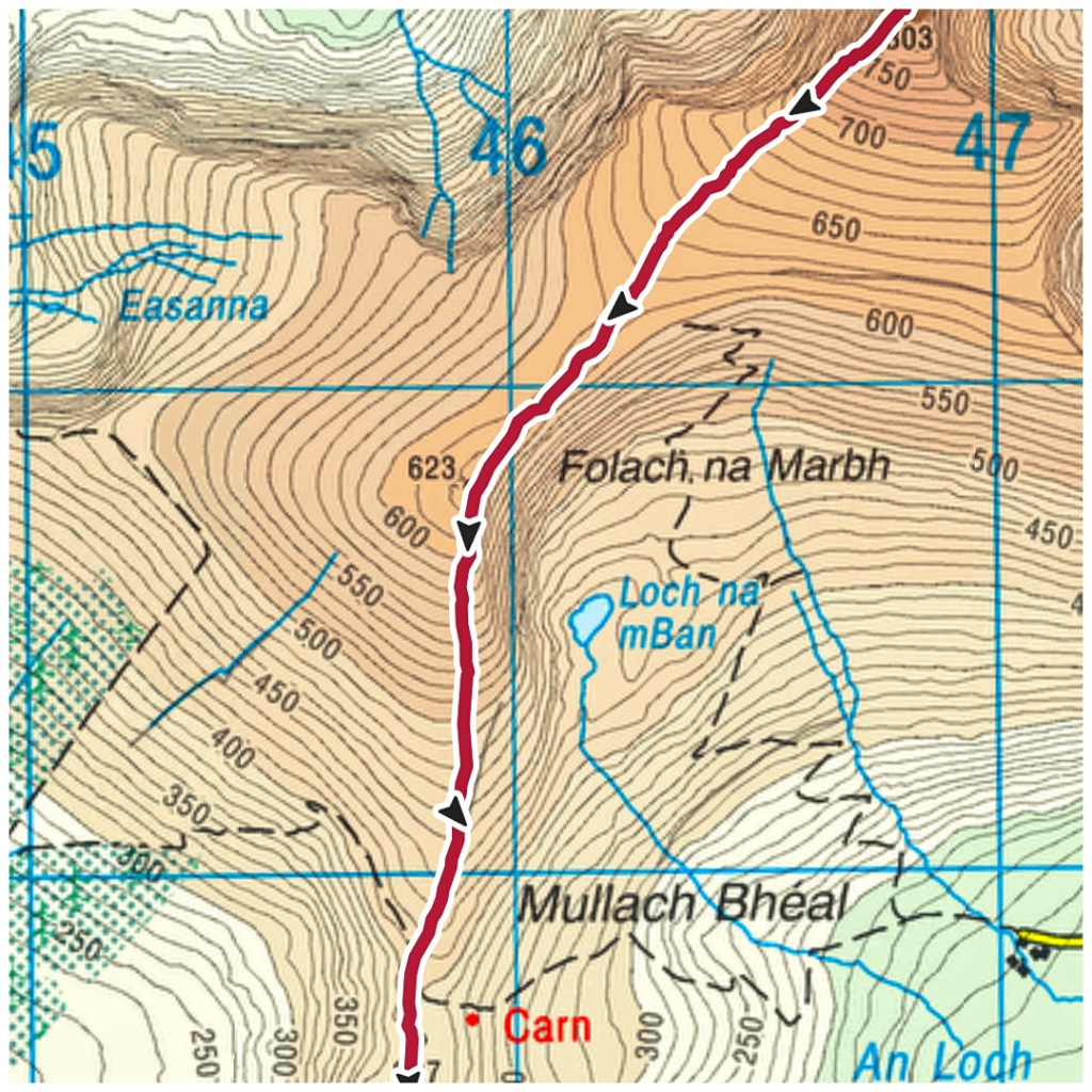
Coming down the fenceline we came to a junction and crossed over. The little marker flags that had marked the way were gone and we soon realised we had lost the proper route. It just shows you how easily it is to get off track in poor visibility as Martin has walked this exact route 4 times before! A few others had made the same error as ourselves and within 5min we realised what we had done wrong and how to swing around back to where we needed to be. You can see clearly on the two maps below where we went wrong.
official route my recorded track
Having gained some height on this loop around the 623m point we dropped back again and reached the unmanned water station at Mullaghveal and 10.5km where we filled both ourselves and our bottles for the next big push.
Along the route so far I’d found it difficult to get food into me. The rain and wind just made it too much work but I took the opportunity here to scoff two bars.
Shortly after leaving Mullaghveal the climbing starts again. Martin told me that this is the last big climb before Connor Pass but that it was a long one. Later we were informed that the summit is called Ballysitteragh but is known on this route as Bally-fucking-sitteragh. It is well named!
I really struggled on this climb. It goes from 400m to 620m in just over 1km and the terrain is pretty boggy and rough. My brain was tired, I was soaked from the waist down and my legs were feeling it by now. However, I really struggled with my breathing. I was very breathless and struggled to get a proper breath at times. I have to say mentally I gave up too!
With many stops I eventually reached the top but once again we couldn’t hang around. We were back in the rain and the wind was really strong again. We pushed on towards Connor Pass for 4km gradually descending but getting absolutely battered by the wind. This was definitely the worst weather I’d ever been out in and the fun was definitely gone today.
Connor Pass came on me unexpectedly at the end. I was expecting a significant drop into a lower altitude level but didn’t realise that the pass sits quite high at 410m. Because I wasn’t expecting it so suddenly the final km to the pass seemed to be never ending but the car park and checkpoint appeared magically out of the clouds.
I have to give a huge amount of credit to the volunteers at this checkpoint. They were waiting here with fruit, cake and water with a smile for everyone, full of positivity in terrible conditions. They were getting battered by the same wind and rain that we had been getting on the hike.
Martin spoke to some of the ladies and we were soon hooked up with a guy (Seamus I think?) that was taking people back to town in his car. We felt pretty shit about having to cut it short, despite knowing it was the sensible thing to do but our guy soon made us feel better when he told us a number of people turned back at the summit of Brandon and quite a lot more came off at the 10km water station. They were expecting a high drop out rate at Connor Pass so he was expecting to be kept busy all day.
We seemed to be taking a long time to get to Annascaul when I suddenly realised that he was taking us to the car park at the very start of the walk! I was really pleased and Seamus really went out of his way to look after us so well. I was expecting to have to get a taxi from Annascaul!
Once back at the cars we wasted no time getting changed into dry clothes and getting some much needed food down our necks. There is a free BBQ in the evening after the walk but we were at least 5-6hrs too early. After a good chat we decided not to wait around and to head for home. Another 7hrs and 480km in the car for me but I felt it was worth it to get back home and sleep in my own bed that night….
Overall I enjoyed my trip to Kerry but I really did feel that it could have been so much more. On the drive home I made the decision to give it another go in 2025 and hopefully get the real experience. I also hope to be at least 10kg lighter and in a lot better shape now that I know what is ahead of me!
I’m finishing this post on Monday afternoon in offline mode somewhere over The Bay of Biscay as we head for Faro and the start of the second part of my holiday break with a family holiday near Albufeira. The forecast for the next few days is 28-30°C and wall-to-wall sunshine ☀
As part of the holiday I hope to be able to complete a hike approximately 30min drive from our accommodation that I found on Outdooractive but seems to be well described in a number of places as it’s part of an official group of waymarked routes.
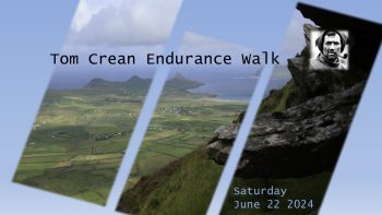
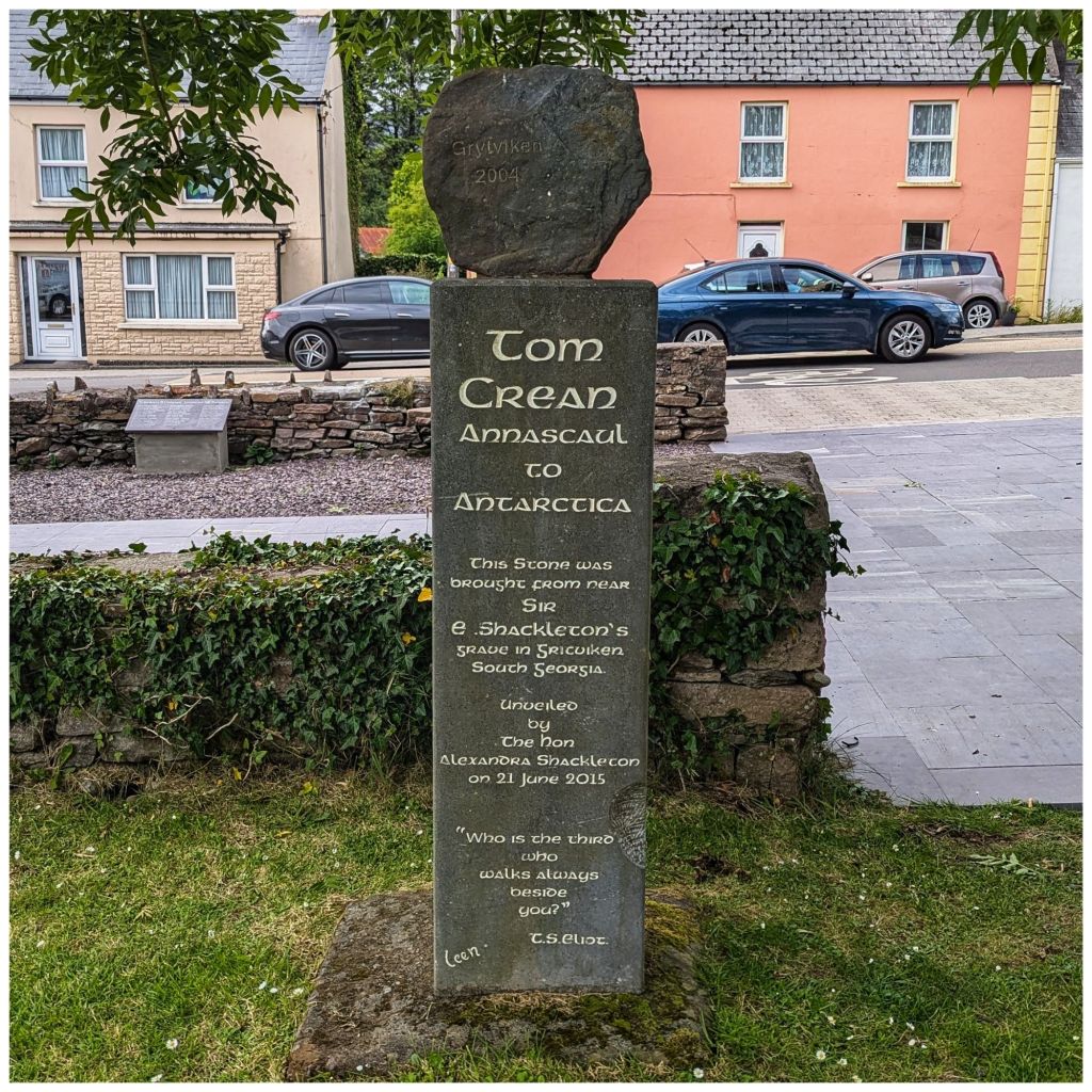
So to kick off my holiday break I’m currently sitting in Co. Kerry. Tomorrow I take part in The Tom Crean Endurance Walk.
This is a 30km mountain hike in the Dingle Peninsula that takes place every year in memory of the Irish Polar explorer. It’s a long drive down from Donegal so I’m here the night before and hopefully will be a great but enjoyable challenge 🤞
short diversion to harvey norman in limerick
I left about 10am and arrived shortly after 5:30pm so I had plenty of short breaks and didn’t rush myself. Check in started at 5:30pm anyway so no point being much earlier!
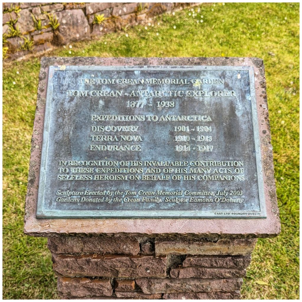
named in memory of tom crean
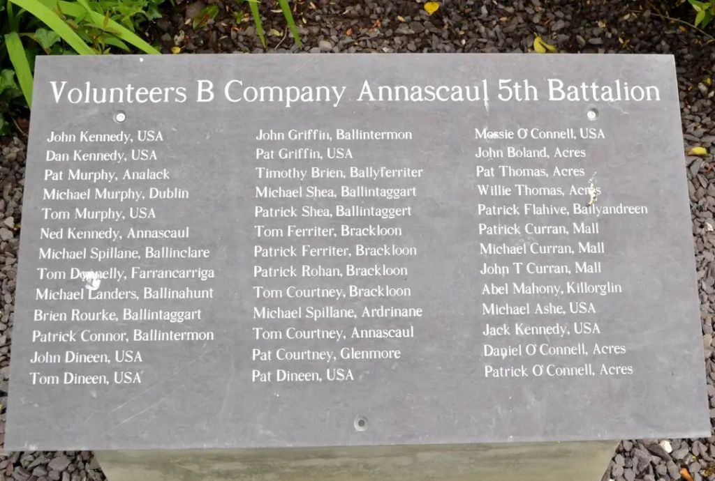
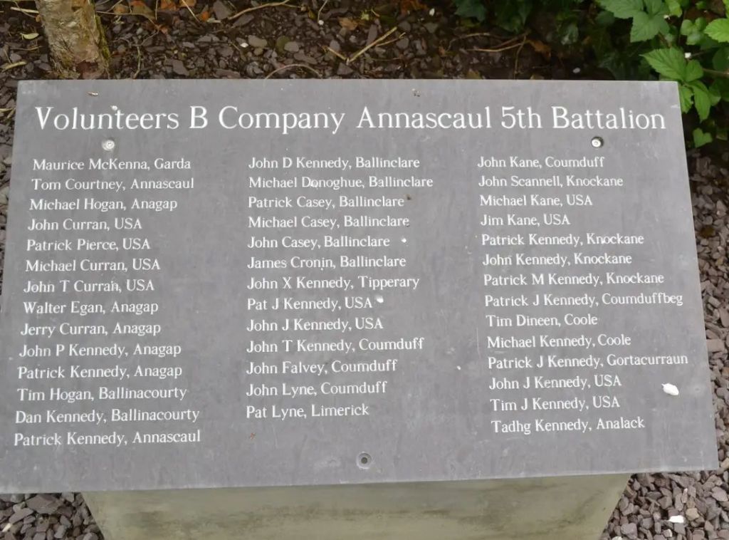
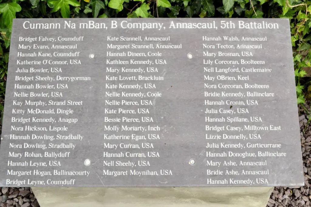
I’m walking with a friend Martin and he’s not due until 7:30pm so I’ve been having a wee wander around and visited the Tom Crean Memorial Garden.
There’s a second memorial just beside it to the many, many people from Annascaul that died in the Irish War of Independence and the Irish Civil War. It’s very sobering, obviously an area proud of their Republican roots….
I didn’t feel it was appropriate to be taking photos but the local historical society have some online already.
Over the last 12 months I’ve had a number of failures in terms of reaching goals I’ve set myself. Each time I’ve set myself a challenging target, worked hard for a period of time, had some kind of knockback and given up. This last few months I’ve given up on a number of things and it had become worrying to me that giving up and admitting failure was becoming too easy. Not that giving up is always bad but it was having a significantly negative effect on me mentally that I wasn’t happy about. My badly organised trip to the Mournes is a perfect example of that trend and the negative effect it had on me.
Then I had a lightbulb moment last week when listening to a podcast and coming across the 25% Rule for the first time….
The bigger our goal is the harder it is for our brain to get on board with doing it. So, the 25% rule is take anything that you want to accomplish, cut it in half and then cut it in half again. This should be your first goal at a minimum, you can even cut it in half again.
For example if I want to ride a 200km Audax event then my goal is not to ride 200km, not even to ride 100km but is to ride 50km. Once I have that done then I can set a new goal. My approach last year was to target a 600km Audax event! Any wonder I failed, any wonder I gave up in April, tanked my motivation and haven’t ridden a bike again until recently!
Last year was the culmination of a number of years of spiralling goal failures that totally destroyed my enjoyment of cycling. Each time I would set a big goal, run out of steam during the process, give up and leave myself totally demotivated. Eventually I would get myself remotivated and set a new goal. Learning nothing from my previous failure this would be an even bigger goal, I would “fail” even earlier and leave myself feeling even more shit than before, take a longer break from cycling and eventually I end up not cycling for almost a full year.
I’ve done this with multiple things, cycling and weight loss being the two most obvious and closely linked but I’ve done it again this year with hiking. Earlier this year I decided that I wanted to do some multi-day hiking. Two YouTube friends (Andrew and Ian) did two big adventures last year that were pretty inspiring. Andrew hiked a large section of the GR221 in Mallorca while Ian hiked The Fisherman’s Trail in Portugal.
Both trips inspired me to do some multi-day hiking myself. Some kind of divine intervention must have occurred as it did dawn on me that heading to a foreign country with little to no backpacking experience was probably not the best idea so I came up with a plan to do something similar in Ireland before committing to a foreign trip. I decided that The International Appalachian Trail was a good idea. I have walked some sections of this during other hikes, have wanted to walk more for a while now and it’s easy to access as it’s all within Ulster. I decided on a 3-Day trip (Dungiven to Castlerock) and a 5-Day trip (Portstewart to Waterfoot)
I scheduled the first trip for the end of March and the second for the end of May so the first one is already done. It was a bit of a disaster! My plan was 18km Day 1, 30km Day 2 and 14km Day 3 for a total of 62km. This was nuts! The only day that made sense was Day 3 and there was no way I was going to be able to walk 30km on Day 2 with a full camping setup especially after 18km on Day 1. I made a video of my experience that I’ll link to below but SPOILER ALERT – I gave up on Day 2!
Coming home from that trip I felt crap. I was pretty much for giving up on backpacking altogether and I was in a real funk for a week or two. Listening to that podcast though made me recognise the traps that I was falling into. I was in a mindset that only big, challenging goals were worth working towards yet not recognising the steps along the way that are needed to achieve these goals. I was doing exactly what the podcast guest described and predictably failing. As I said at the top this was a bit of a lightbulb moment for me.
What am I doing differently now? First of all I have totally revised my plans for the IAT in May. Instead of a 5-Day 95km trip I’m now planning a 3-Day 45km trip taking a much more achievable 15km per day average. Instead of walking from Portstewart to Waterfoot I’m only going to do the Moyle Way section from Ballycastle to Waterfoot. I’ve walked this distance in training and I know I can do it.
I’ve also got myself back on the bike! Nothing spectacular but I have a pretty low base that I’m re-starting from. Virtually all my cycling fitness has evaporated and it will take some time to get it back. Instead of setting myself big targets I’m being conservative. My first goal is just to get out regularly. I have a simple 20km loop close to home and my plan is to ride that twice a week (hopefully 3) until I get some kind of legs back again. If I can get myself built up to a 50km ride by the end of the summer then I’ll be very happy but I’m not putting myself under any pressure. It’s time to go back to where I started and maybe remember why I enjoyed cycling again!
I have had this idea in my head the last couple of years that I don’t have time to devote to cycling and hiking, that if I’m going to be really good at either one then I won’t be able to do the other. I’ve now realised that I don’t need to climb Everest or ride 600km in a weekend and that I can enjoy both by relaxing, enjoying the process and mixing them up as much as I can.
Now all I need is a decent Summer to get weather that will make it all more enjoyable…
On Sunday I went on a road trip to the Mourne Mountains and ended up getting my arse handed to me! This was my third visit. My first two were in September 2022 and May 2023 (video link). Both of these trips were near perfect and I really enjoyed them. I was hoping for a perfect hat-trick but this time I was denied. I guess I was due….
A big part of the problem was myself and my planning. I was determined that it had to be this weekend to fit in with my work schedule and my plans for next weekend. The weather was always going to be iffy (drizzle and showers in the afternoon with a risk of low cloud) but with fairly mild temperatures and not much wind I figured it would be OK.
My plan was to wild camp on Slieve Bearnagh and with a good Monday morning forecast I was hoping for a good hike and a chance to practice my camping strategy before next week. Maybe even a lovely sunrise…
Piss Poor Planning Promotes Piss Poor Performance
My route planning was the biggest problem. I’d copied the route from Paddy Dillon’s book Exploring The North of Ireland and converted it to a digital version on Outdoor Active. Paddy’s book works in both KM and miles and somehow I’d gotten it into my head that the total route was 10km. It was 10miles or 16km!
My plan was to start late, around noon, allow a conservative 4hrs to summit Bearnagh and have an hour or two to find a good camping spot and get set up well before dark.
Instead of Bearnagh being 8km into the walk it was 8 miles and with an awful lot of up before that. I only realised this distance error when I was 1.5 hours into my hike.
elevation profile
The terrain also wasn’t what I expected and I made a bad choice of footwear. On my previous trips I’d worn my usual leather boots and gaiters but I was amazed by the lovely gravelly tracks and absence of bog that I’m accustomed to in Donegal. I expected the same again and went for the lighter option of my Topo Athletic Terraventure boots. What I didn’t allow for was the difference between walking in March versus May and September and the deluge of rain we have suffered for the last 8-10 months. The tracks and paths were swimming with runoff and the ground was soggy and boggy. The boots coped fine with both but the bottoms of my trousers were soon soaked which inevitably led to wet socks and wet feet.
The route follows The Mourne Way from Meelmore Lodge around Fofanny Dam Reservoir and after a short stretch of road joins The Ott Track and into the higher ground. The waymarked path is supposed to follow a raised bank along the edge of the reservoir but it was closed due to a problem at the Southern end. However, there was no marked diversion. A vague path was visible through the long grass to the opposite East side of the channel that the track should follow. This turned out to be horrible ground. It was wet and boggy with long grass and hidden holes. At the end of this section I was then on the wrong side of two fairly substantial streams that I had to negotiate before scrambling over a wall back into the forest and on to the official path. By now my lower legs were soaked and one boot had been submerged in a hidden bog hole leaving me very disheartened and feeling sorry for myself. To add insult to injury I’d been walking in steady, heavy drizzle pretty much from the start of the walk.
Leaving the road and heading along the Ott Track I started to climb up into the cloud and it was at this stage I realised my mistake about how long the route actually was.
enjoying the wonderful views, check out my glasses! heading into the clouds
The track in the photo above peters out and a series of rocky then boggy then rocky once again sections brought me to the Mourne Wall which was to be my constant companion for the rest of the day. Over the stile I met a young couple with a small toddler (not much more than a year old I’d say?) that the fella had been carrying in one of those back pack carriers. It must have seemed like a good idea at some stage but they looked fairly miserable when I met them!
The first summit was Slieve Loughshannagh (619m) and was a steady but manageable climb from the stile.
heading into the mist slieve loughshannagh summit cairn
I stopped for a short break just off the summit and I’m pretty sure it was here that my head went. It was back to the heavy drizzle, I couldn’t see a thing, I had 7.5km done, 3 more summits to go, all with steep climbs and the weight of my bag was really starting to make itself felt. I was contemplating descending Slieve Loughshannagh and taking the path that skirts around and avoids Slieve Meelbeg and Meelmore completely to bring me to the base of Slieve Bearnagh. However, at the base I somehow overcame this urge and pushed on.
Slieve Meelbeg (708m) is a damn steep climb from this side and it seemed to take forever to get to the summit. I was counting steps and taking lots of short breaks to ease the burning in my legs and to try and keep my heart rate under some kind of control. My bag felt like a ton weight by now.
Looking at the map it wasn’t exactly clear where the summit was in relation to the Wall but it soon dawned on me that it was on the other side but I wasn’t going to attempt climbing over just to touch the cairn. By clambering up enough to see over the Wall I was automatically higher than the summit anyway 😉
searching for the summit
At the top of Meelbeg I was ready to give up and go home. I was feeling really sorry for myself and had another opt out option at the next col. I’d had enough of the rain and low cloud and was really tired. I was dreading the climb to Meelmore, the drop to the col and the big climb to Bearnagh. I was starting to panic about time and getting set up for camp.
The drop down off Meelbeg was pretty easy and rather than give my mind any more space I simply plowed on, ignoring the other path options and headed up Meelmore. This was a much gentler climb than Meelbeg to the summit at 687m. Once again though I was on the wrong side of the Wall and so focused on the shelter at the corner of the Wall I actually walked past the summit without realising it!
meelmore shelter
On the way up Meelmore the drizzle finally stopped for a while and as I approached the shelter there was a brief lift in the clouds giving me a short tantalising view of the valley below and across to the bulk of Bearnagh. This lifted my spirits considerably and I was getting my head back in the zone, feeling like I could do this after all. A short break here, out of the wind, some food to boost my mood and energy, descend to the col, restock my water and push on to Bearnagh with hopefully enough daylight left to find a decent camp spot.
As I finished my snack the cloud thickened and the rain returned. This time it was light rain rather than drizzle. The descent from Meelbeg is pretty tough. The ground is very steep and incredibly rocky. Large slabs and rocks made for difficult path finding and the hard, uneven surface demanded full attention. This was exhausting both physically and mentally. About halfway down it got quite dark and windy and the rain turned heavy making the already wet rocks even more slippery. By the time I reached the col below Bearnagh I was soaked and done in. Getting battered by the wind I scrambled over the stile in the Wall and found what shelter I could in the lee out of the wind.
Staring across at Bearnagh the route looked like it was almost vertical. The rocky face disappeared into the clouds and I simply gave up! I seriously doubted I could physically make it up to the summit and with the disappearing light and increasing winds I began to panic about finding a camping spot and getting a tent set up for the night. I knew I could divert here and take the path down to meet The Trassey Track and back to my car at Meelmore Lodge. The thought of a wet camp and having to get dressed in the morning in my wet clothes and boots really didn’t sound like fun.
Leaving the Wall I slowly trudged my way down the track. I was totally demoralised, wet and exhausted and dreading the walk back to the car. The path was a mess. It was mostly submerged in 3-5cm of running water as the mountains shed the latest rain and the strong gusts buffeting my back made me unsteady on already tired legs.
As an example of my state of mind I was half an hour down the track when I realised I was carrying about 500ml of water that I no longer needed and that would go a small way towards lightening my load. It took me at least 5 goes to get the slippery empty bottle back into my side pocket. I dropped it every time and I have a clear memory of yelling FUCK! and almost throwing it in the nearby river….
Approximately half an hour further on the weather changed in a matter of minutes. The clouds lifted and the rain stopped. A beautiful setting sun appeared in the distance ahead of me and the mountains suddenly appeared behind me. It sounds nonsense now but it was like the mountains decided that day that I didn’t belong. They chewed me up after Meelbeg and spat me back out and when I was almost away they were like “fuck you, this is what you missed!“
bearnagh snubbing its nose at mepollaphuca gap with bearnagh left and meelbeg right
It took me almost 1.5 hours to walk back to the car. Approximately 4km and mostly downhill. There were two tricky stream crossings just after I left The Trassey Track but at that stage I could see the car and couldn’t care so pretty much just splashed across!
The physical demands of the route, the difficulty of the terrain and weather plus the impact of carrying the additional weight of a camping setup really caught me out. This was supposed to be a final preparation for my multi day trip this weekend and a chance to practice my camping strategy. Instead it really knocked my confidence and created extra concerns. It took me until Wednesday to recover fully with a lot of aches up until lunchtime and it was only yesterday that I felt mentally confident to stop worrying about the upcoming trip and get my head in the right place.
The upcoming trip is Stage 6 of the International Appalachian Trail Ulster-Ireland: Dungiven to Castlerock Incorporating The North Sperrins Way. It’s 62km and I’m aiming for 3 days with wild camping on both nights. The weather on Sunday and Tuesday looks OK but wet on Monday which will be my longest day. However, although the distances are greater there is nothing like the elevation changes of Sunday. I’m staying positive and giving myself lots of time to get to the spots I’ve picked out.
sunday’s hike. click here to view on outdooractive
In 2021 I started the year by climbing Mount Errigal on New Year’s Day to experience the sunrise from the summit. It was an unforgettable experience that I didn’t want to be a one-off. 2022 saw a very stormy start to the year forcing me to give up the idea and last year I was laid low by a horrible cold.
I’ve been watching the weather for the last 10 days with an eagle eye. MountainForecast.com has been up and down but the last few days it steadied out to be mostly dry and promising decent visibility so I was set to go.
To tease further I saw a number of posts online with photos of Errigal with a decent covering of snow. The summit forecast was giving snow showers for at least 24hrs ahead of NYD and with temperatures close to zero and a significant windchill I was expecting a wintery summit.
I arrived at the car park just before 6am and was walking by approximately 620am. The trick was to allow enough time to get to the top without killing myself but not arrive too early and have to suffer the cold for too long.
A van arrived at the car park just after me but the two guys started before me. Another guy arrived after I’d started but he passed me fairly quickly. I could see other cars arriving and lights on the track behind me but with my head start I had the hill all to myself for the full climb.
Since my last visit the path has had extensive work which made for a much more enjoyable hike. The slog across the wet bog has been replaced by a gravel and stone path and the slippery gravel climb of the mountain has been stabilised with a rocky path. I was worried that the mountain experience would have been spoiled but it’s been excellently done and is a much better climb as well as being better for the mountain itself. The descent was especially noticeably more enjoyable compared to the last time.
Having a breather at the circular stone shelter below the last climb to the summit I played around a little with the camera on my new phone. This shot was taken in the dark with only the moon to help!
I sheltered below the summit for about 20min before making the final push, arriving at the first peak just before 8am. The sky was showing the first signs of dawn with a small bank of cloud breaking apart.
After about 15min a group arrived and with limited space I crossed over to the second peak. The guys from the car park were here ahead of me and one kindly took a summit photo for me.
As the sun came up the sky continued to lighten and the landscape below started to appear from the darkness.
A thick band of cloud moved in, threatening to spoil the sunrise but eventually we spotted the orange ball of the sun breaking through.
At 9am it looked like that was all we were getting so I started to head back down. Just below the summit the clouds parted and we were treated to the full sunrise after all 😍
Halfway down a shower of rain and hail blew in but combined with the sun to provide us with a magical rainbow to finish the hike.
A magical start to 2024. Happy New Year Everyone 🥳 🥳 🥳
Header image by Aodh Mairtin O Fearraigh and published by “Donegal Has It All“.
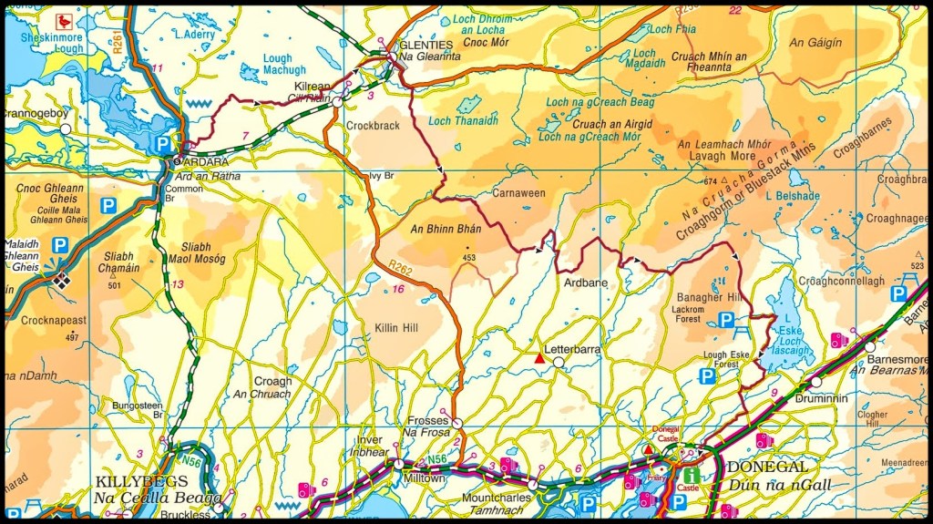
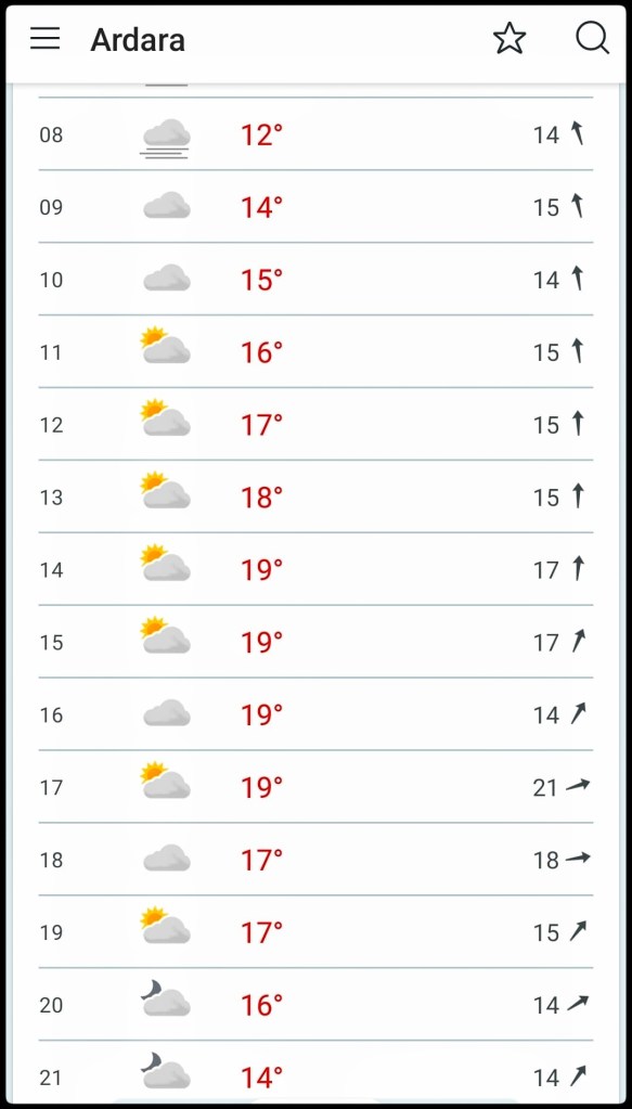
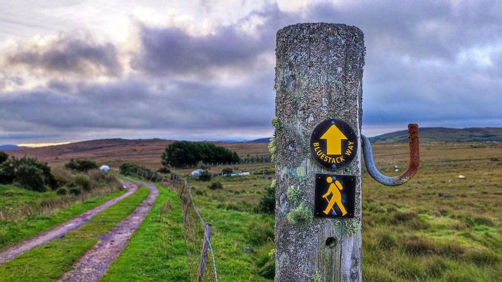
So I finally did it! The Bluestack Way in a Day – 52km from Ardara to Donegal Town via Glenties on a mixture of tarmac roads, forest and bog tracks and some open hillside. It’s one of my biggest achievements and also one of the hardest, most physically and mentally demanding things I’ve ever done!
My original date that I decided on way back in May was Sunday 27th August. This gave me 12 weeks to “train” and also gave me a good window of daylight to complete the walk. My aim was to start at 730am, aiming for a 12hr finish but planning for 14hrs if needed. Going from Ardara meant that the last 10km were on tarmac roads and easier and safer to walk in the dark, if necessary, with a headtorch and hi viz jacket.
I also had a mental option to delay by one week to allow for any last minute issues such as injury or weather. In the end up I did delay and the walk ended up happening on Sunday 3rd September. The previous Sunday was a day of heavy rain and I decided the walk was difficult enough without trying to complete it in conditions like that. Plus the long range forecasts were all shouting about a change in the weather to warm and dry with Sunday 3rd looking pretty much perfect.
Sunday 3rd September
The final decision to postpone wasn’t made until Saturday 26th so the week running up to this was my prep week for the event with 2 x 20km walks at the weekend and a few shorter 5km walks mid week before resting a few days. I was also in bed by 930pm each night trying to build my reserves for the weekend. I was mentally focused and ready to go. The deflation of not going on Sunday kind of caught me unawares and left me feeling very unfocused in to Monday, like post-event blues without the event! It was a real effort to build myself back up for the weekend and I ended up going into Sunday feeling less prepared and pretty nervous.
We left home just after 6am for the 1hr drive to Ardara with nerves gradually building in my belly the whole way. Getting out of the car in an eerily quiet and grey Ardara my legs felt quite wobbly and I had a brief moment of panic. A big hug and kiss from Catriona and I told her to head home to give me a chance to settle myself and get started – no way back now! I took a couple of quick and shaky shots of the first sign post of the day, settled my bags, pressed start on my Garmin and took my first of what turned out to be 69,728 steps.
Ardara
I was really looking forward to this first section to Glenties as it was totally unknown to me. I’d watched a couple of videos on YouTube of other people that had walked the Bluestack Way and knew that a lot of it was along the banks of the Owenea River. ToughSoles in particular were big fans of this section and I hoped to enjoy it.
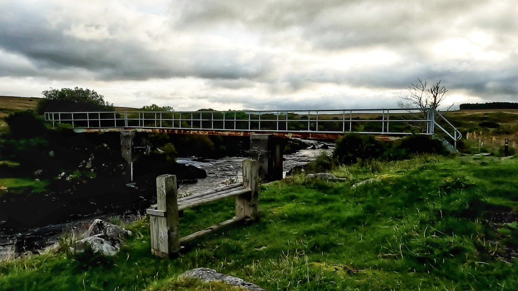
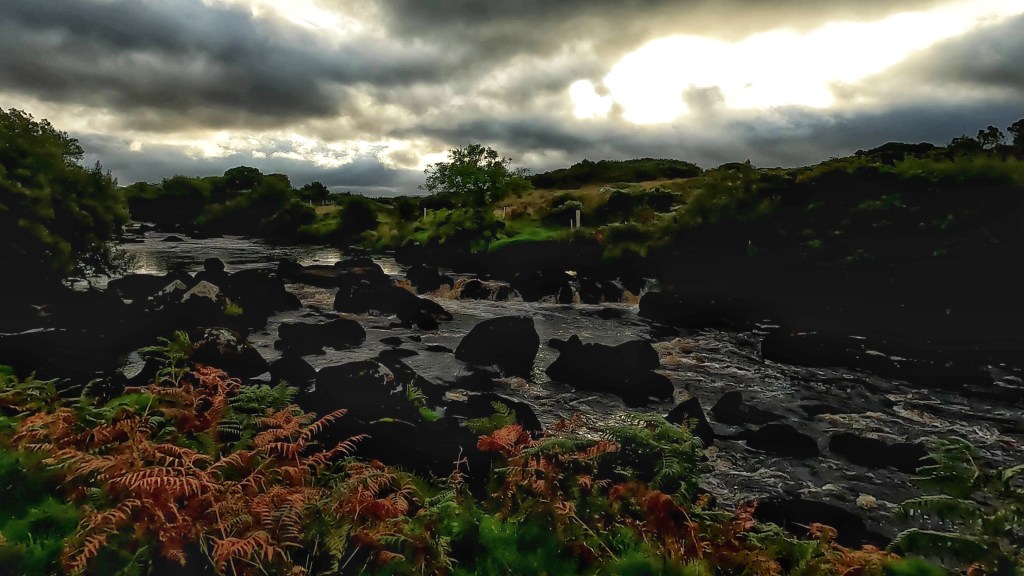
The river was beautiful. After a short section through the town and a gravelled track I wound down to the river. It’s obviously a popular fishing spot with proper bridges and clear tracks on both banks with stiles and boardwalks to help cross fences and boggy sections. Along the way I saw quite a few ducks, most of them flapping away startled by my presence on this early morning. I also heard a few fish rising for early flies and judging by the noise and resulting rings in the water they must have been pretty sizeable. I was hoping to see herons along the river but I suspect they wouldn’t be too popular with the local fishermen and have probably been discouraged from settling in the area.
A lot of the riverside path is bordered on each side by bracken. Enterprising spiders have realised that spinning a huge web across the path will trap insects as they fly between. Unfortunately for them I was having to destroy all their hard work by breaking down their webs to get past. It felt like a cross between Indiana Jones and Lord of the Rings as the spiders were huge and obviously (normally!) well fed. Most of them were about the size of a 20c/2p coin and I really didn’t fancy having them crawling on my bare legs, especially pissed off having had their web destroyed!
Eventually it was time to leave the river and skirting the edge of a field I followed the path to the first tarmac since leaving Ardara. A 3.5km straight run brought me to the edge of Glenties and along the main street exiting the town on the back road to Ballybofey beside the Garda station. A surprisingly well maintained and clean public toilet (must be the only remaining Council operated toilet in Donegal!) allowed me the luxury of not having to dig a cat hole in the wilds because no matter how much I enjoy the outdoors nobody likes having a dump outside!
Leaving a very highly decorated Glenties (this was the weekend of the Harvest Festival) I followed the tarmac road for approximately 1.5km before crossing back over the now much narrower Owenea River and back on to gravel tracks. The road out of Glenties was much more pleasant than the way in as it wound through sections of large trees with nice cottages and houses with quirky garden displays. This was my last signs of civilisation until arriving in Donegal Town almost 40km later!
The gravel track climbed steeply away from the river taking me past long abandoned homes and farmyards still locked up and quiet on this Sunday morning. This was a bit of a lung-buster with slippery conditions underfoot and a number of gates and stiles to negotiate but taking breathers and looking back I could see how quickly I was gaining height with great views back over Glenties, back towards Ardara and out towards the coast with Slievetooey looming away off in the distance.
Eventually reaching the top of this low ridge I got my first proper views of the Bluestack range itself. The track ahead ran in an almost straight line for 2-3km with a variety of conditions underfoot from gravelly to squelchy sections of bog, some bare of vegetation for 10-20m at a time while other sections were overgrown with long grass and small bushes. This was my first indication that the terrain was going to be a lot wetter than expected and that I’d made a mistake with my decision to wear trail shoes.
The first section of this bog track was very exposed with a strong Westerly wind, the first and only windy section of the whole day. After approximately 1km I reached a forested section with the trees on my left somehow reducing the force of the wind coming from my right. The breeze was still strong enough to keep me from overheating in what had turned into a very sunny day as well as preventing any midges from coming out to feast.
This boggy track eventually reached a gate and a much better surfaced forest access trail. Coming around the next corner I had a sudden recognition of this spot from walking the 30km Bluestack Challenge Walk in 2012. This was where the Army had set up a tented food station with bacon baps and tea. I could have murdered one of those at this stage today!
Just past this spot the route takes a sharp turn to follow the Owenroe river as it tumbles noisily through the narrow ravine below the track. This is where the alternative “lowland” section also starts. This alternative avoids the higher ground for anyone that doesn’t fancy it or when there is particularly bad weather. I, of course, was taking the high route.
Walking along this track with a mature forest plantation on my right and the river rushing below on my left was really enjoyable. As the path flattened out I had really good views of the craggy summit of Carnaween off to the East. The sun was out and I was feeling good. I was tempted to refill my water from the river but I still had over a litre and didn’t fancy the scramble down and back up from the river. This turned out to be a bad decision as my water choices for the rest of the day were very limited.
Eventually the track petered out and it was time to head on to the open hillside as the route headed up and over the shallow col below Cloghmeen Hill. At slightly over 400m this was the highest elevation of the whole route. At the access gate a picnic bench sat looking very out of place and seemed like it would be completely in the way of any machinery looking access to the moorland above. An abandoned Race Ireland sign from an old event helpfully told me it was 20km but I’m not sure where from. It did coincide with my distance since Ardara but I think it related to the distance from Lough Eske coming towards Glenties based on the orientation of some signs found further along the route.
It was on the climb over this ridge that the wheels came off the wagon for this walk, where my choice of footwear was proven to be a disaster and this was clear within the first few steps. The terrain changed from track to open grazed moorland, so typical of the Bluestacks. It was also incredibly wet! Every step was a squelch, the ground was saturated with thick moss below the layer of grass. Water was squeezing out of the soil and within 10m my shoes and feet were soaking wet. The climb was steep but not incredibly difficult. However, with tired legs after 20km, shoes that now felt like blocks of concrete and heavy ground it was a slog to the top. At the top of this ridge the route bears left with the official summit of Cloghmeen Hill some 50-100m to the right. My original plan was to make a short detour at this point to grab the summit but with serious concerns about my shoes, the boggy approach to the summit and legs drained after the climb up I decided to focus on getting off the hill instead.
The drop down the other side of the ridge was steeper than the ascent but just as wet and I’m sure it was here that the majority of the damage was done to my feet. With socks and shoes completely sodden my feet were moving far more than usual in my shoes and my weight was focused towards the front of my feet creating friction that wet skin could do without. By the time I reached the bottom, followed the route as it inexplicably weaved through the walls of an abandoned and overgrown homestead and out to the gravel track where it rejoined with the alternative route, I knew I was going to have problems for the rest of the day. I could feel a burning sensation on the pads of both feet, just behind my toes as well as on the heel of my right foot despite having it really well taped specifically to prevent blisters.
My original plan was always to take a longer break at Letterbarrow soccer pitch which was at the 27/28km mark. I’d planned to get my shoes off, retape my feet and put on fresh socks. This was going to be even more crucial now than I had planned.
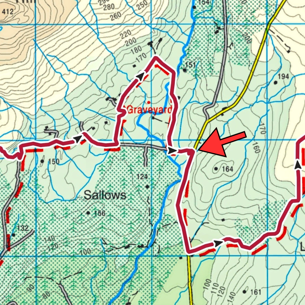
The Bluestack Way takes what seems like a random loop just a few hundred metres from Letterbarrow pitch. It brings you back to the same road having walked an extra kilometre up and down a fairly steep hillside. The aim is not to piss you off but to bring you past the ancient Disert Graveyard. Again, on any other day I would have been tempted to pay this spot a visit but I pushed on past the entrance, focused on getting to the pitch and getting my shoes off.
The arrow marks the pitch.
The one advantage of the extra walk was that my feet squeezed most of the water out of my shoes leaving them a tiny bit drier and not completely waterlogged. Reaching a picnic bench at the back of the clubhouse it was like heaven to finally sit down on a proper seat and peel off my sodden socks. Leaving my shoes in the strong sunshine I let my feet dry out and breathe in the warm air for 20min while I lay back and rested having eaten most of a flapjack bar to fill my belly. Restarting with fresh tape, blister patches and clean, dry socks my feet, though tender, felt so much better.
I had also hoped for an outside tap at the clubhouse but there was none. Reading the rules for an unsupported FKT attempt I since realised that water can only be taken from natural sources so it’s just as well!
A short section of tarmac route and I was once again diverting on to gravel tracks. The first section was through a farmyard with loads of warning signs on the gate about trespassing and liability etc. It was all a bit intimidating but the waypoint signs gave me the confidence to keep on. A few more gates with similar signs and I was in a short section of cool, shady forestry before popping out on a wide flat bog area with beautiful, expansive views of the high Bluestack range. I could pick out some familiar hills and had a brilliant view of the Sruell Gap and just a peek of The Grey Mare’s Tail waterfall that I saw up close a few months ago.
Sruell Gap in the middle, Croaghgorm on the right Close up, Grey Mare’s Tail Waterfall just about visible on the left
This section of bog is also extensively used for turf harvesting. There were some stacks of bags sitting ready to be taken home with many more bags sitting in rows ready for lifting. There was one group of men busily loading a quad trailer and transferring bags to a tractor trailer for taking home. Harvesting turf is very labour intensive and I often wonder if the payback is worth the effort involved. One thing for sure though is that turf will heat you many times over, not just when you burn it!
A sharp right turn in the middle of the bog brought me back to tarmac and the familiar road that takes you to the start of Sruell Gap. A short walk along this remote single track road and I was sent on to another track and over a concrete slab bridge across the Sruell River as it tumbled down from the gap. Over the bridge and it was back to a low section of trackless grassland. Boggy again but thankfully not a sponge like earlier and I was able to find enough rocky spots and firmish ground to avoid any more water getting in to my shoes. If anyone saw me gingerly stepping across the fields I must have been like a middle aged child trying to avoid the cracks on a pavement!
It was somewhere across this section that I passed the 33km mark and was now officially on the longest walk I’d ever done in a day. My previous record was 33.1km in March 2022
March 2022
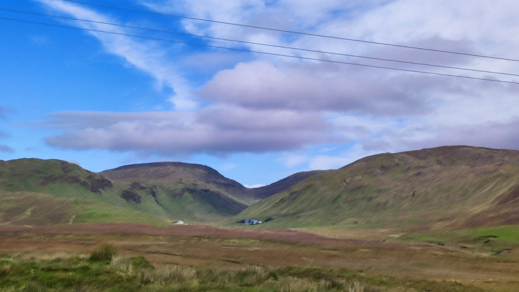
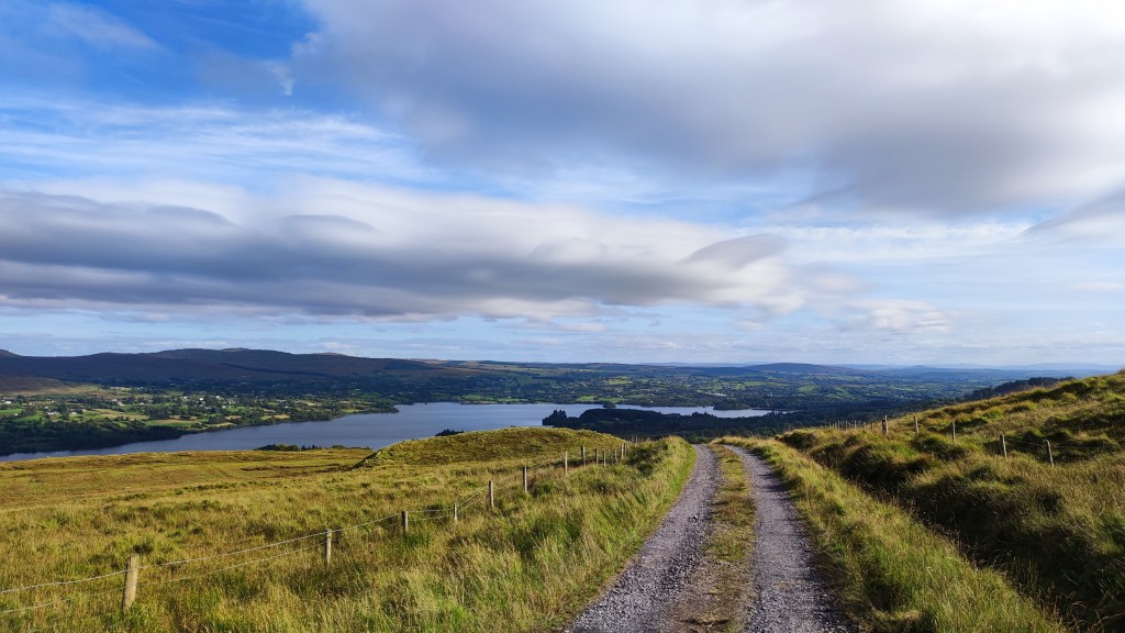
Another short section of tarmac brought me to the Eglish River and a very familiar gravel trail that curves around Banagher Hill and along the Eglish Valley with more expansive views of the Bluestack ridge. I’ve been on the lower section of this track a number of times, most recently just 4 weeks ago, so I was really beginning to feel like I was on home ground now. The track ascends gently as it rounds Banagher Hill until eventually you are rewarded with the very welcome view out over beautiful Lough Eske and Donegal Town in the distance. Still 13km to go but I could sense the end.
Lough Eske
For the next 3km it was a steady downhill on gravel which eventually morphed into tarmac, steadily dropping down towards Lough Eske. On the way down I met a lady with her dog She asked if I was walking the Bluestack Way and was very impressed when she asked where I started and I said Ardara. Her jaw nearly hit the floor when I told her I was going the whole way to Donegal Town. She hopes to walk it in two days and was amazed I was doing it in one!
I really needed this boost though. The dampness from my shoes had now penetrated both pairs of dry socks and I was back to walking with wet and increasingly painful feet. The pads of both feet and my right heel were burning, a sure sign that blisters were developing. At this stage it was now a matter of every step was one step closer to the end.
Once down close to Lough Eske I joined the fairly busy scenic road that loops around the West shore but thankfully only for a few hundred metres as lots of people were out for a drive on this lovely Sunday afternoon.
The route leaves the road to descend through the tree-lined narrow road that skirts the edge of Ardamona Nature Reserve and the very edge of the lough before arriving at Harvey’s Point Hotel. Just before the turnoff I was finally able to get access to the small Clady River as it tumbled down the steep hillside from Banagher Lough high up in the mountains above. My water bladder was completely empty and I had no water for almost an hour at this stage. I wasn’t happy with any water sources up to now as the route had come through grassland that was heavily grazed with sheep and nothing was flowing fast enough to give me confidence until now. A couple of shots with my filter gave me almost a litre and enough to keep me going to the end.
Just before Harvey’s Point I passed the significant 42km milestone. In old money this is just over 26 miles and the distance of a marathon. I doubt I’ll ever run a marathon but it felt damn good to have walked one! Still another 10K to go though…
Reaching the hotel entry gates and heading along the road towards the Famine Pot junction I was tormented by cars and a couple of buses. This is a popular hotel and this is the only access road. After the peace and tranquility of the whole day up to now this was a real culture shock and I was very relieved to see the marker post sending me off the road and into the forest that surrounds Lough Eske Castle Hotel right on the lough shore and thankfully away from all the traffic.
This section was absolutely gorgeous but I was really starting to suffer at this stage and couldn’t enjoy it anywhere close to what it deserved. It was a wonderfully cool variety of shaded forest paths and gravelly tracks through the trees and boardwalk right on the very edge of the lake. Swans and ducks were enjoying the water which was visible through small breaks in the tall shoreline foliage. The path meanders through this beautifully tranquil area for approximately 3km but to me it felt like an eternity. In among the trees I lost all sense of progress and every step felt like walking on broken glass. I hit a massive low point through here and for the first time really felt like packing it in. Even eating was a chore with the flapjack bar feeling like sawdust in my mouth and having to be forced down. Looking back I was probably suffering from dehydration and maybe even a touch of heatstroke at this point.
I have a memory of leaning on the rail of a small bridge over a little stream, my forehead resting on the wood, arms dangling loosely and feeling for all the world like I could burst into tears. My feet were in bits and my head was gone. SomehowI managed to drag myself out of this and forced myself to get moving. I had about 7-8km left and couldn’t give up now!
Emerging from the never ending tunnel of trees (usually my favourite environment!) I came back to the road at a junction I’ve driven through maybe a hundred times. It was here that the switch flipped back to positive. Despite having at least another hour to go to reach Donegal Town this was the first point where I thought “I’m gonna do this!“. Every step was horribly painful but every step was closer to the end, I just kept repeating this in my head as I trudged along the narrow little rural road towards town.
Along the way there were three steep little hills, those you would think nothing of regularly, the ones on a bike where you keep the high gear, stand up and push for the top to keep momentum and enjoy the short, fast descent on the other side. Today they were agony, heavy, tired legs on the climb up and burning, blistered feet on the other side. “Every step is another step closer to the end“…..
Suddenly I seemed to be approaching the busy bypass that skirts around the edge of Donegal Town. The volume and speed of traffic had me in a bit of a panic that I wouldn’t be able to cross safely, shuffling along as I was, hardly able to walk never mind run! Then, just before the junction, a small waymarker sent me to the right via a barely visible narrow footpath that went through the hedge, dropped down to a wild and noisy River Eske, past a very impressive and noisy waterfall, passed under the main road and out the other side to a housing estate on the edge of town.
Looking at the map at home I thought that I was to come out in the town via the old railway yard and close to the Diamond. Entering this housing estate I thought I was close to the end. Walking through to the main road I suddenly realised I was wrong, I was on the far eastern edge of town and still had well over a full kilometre to go but “Every step is another step closer to the end“…..
I have to say I absolutely hated this last section. It was totally unexpected, on footpaths beside a busy road and seemed to go on for ever! I was meeting people out for a Sunday evening walk and I must have looked like shit, I certainly felt like I did anyway. It was a real effort to summon enough energy to reply to friendly smiles and hellos and I’m sure they must have thought I was a complete weirdo!
Eventually I reached the Church and could feel the road start to slope down towards the Diamond. Rounding a final corner I could see it ahead and all of a sudden I saw Catriona getting out of the car. Her hand in mine, a quick hug and kiss felt like the best feeling in the world but I couldn’t stop, I was afraid I wouldn’t start again! I switched on the GoPro, and she scooted ahead to film my on the final hundred metres into the Diamond and to the marker commemorative stone at the far side where I slumped down, physically and mentally exhausted and totally unable to film a final piece on camera. But, I’d done it, I’d walked “The Bluestack Way in a Day!” I’d actually bloody done it and despite being wrecked I was overjoyed…..
For anyone that follows me on Strava it probably appears that I’ve fallen off the face of the Earth or have decided to rededicate my life to the couch potato lifestyle. While I’m no athlete I haven’t been completely idle either.
At the beginning of May I came to the realisation that cycling had become something of a chore, it had developed into an activity I was doing for reasons other than enjoyment. It wasn’t that I’d fallen out of love with cycling, it was that I’d rekindled my old love of hillwalking (or hiking if you prefer) and walking in general and I was finding them much more fulfilling than cycling. I’ve spent a lot more time in the hills this year and rediscovered why I enjoyed it so much. For the last 10 years I’ve defined myself as a cyclist so, while I haven’t turned a pedal since the 26th of April, I don’t think I’m finished completely and have no intention of getting rid of my bikes.
Me being me, I felt the need for a challenge to motivate a daily walking habit to build strength and fitness for my weekend trips into the hills. With my 50th birthday this year (now into the final countdown) I also wanted this challenge to be out of the ordinary and something I’d have to push myself to the limit to achieve. I wanted a walking challenge to replicate the challenge of Audax.
While looking for ideas I took my inspiration from two illustrious sources. Fellow blogger Unironedman (Declan) is an avid runner with many long distance challenges under his belt. Last year he organised and completed an FKT (Fastest Known Time) attempt on the 115km long St. Declan’s Way. You can read his description of the “Day on the Way” here and watch his video below.
This year Declan completed a run of the full Wicklow Way (~130km) as a memorial to his recently deceased Dad. You can also read about that epic adventure here.
My second source of inspiration was (is?) Ellie from the excellent Tough Soles. Ellie and her partner Carl have a well established website and YouTube channel that originally started as a challenge to walk every official waymarked trail in Ireland. They completed this a while ago but the channel is still going strong. Ellie is currently climbing every Vandeleur-Lynam peak in Ireland (600m+) on back to back days. More info on their website or follow their channel to see how she gets on.
In July last year Ellie ran the 56km Leitrim Way setting an FKT in the process. She documented that day and you can watch the video below.
Despite flirting with running a few years ago I’m not very good at it and just about managed to get to the 5K distance. Ultra-running is simply not for me. However, ultra-walking (any distance greater than a marathon – 42km) is also a thing and walking I am good at!
My nearest waymarked trail is The Bluestack Way. It runs from Donegal Town through the Bluestack Mountains to Glenties and finishes in Ardara. I’ve walked bits of it to access walks in the Bluestacks and I walked a large chunk of it in 2012 on the 30km Bluestack Challenge. Overall it is 52km although, in typical Irish fashion, it is listed as 65km. This is because there is a lower level alternative route for the more mountainous section, that is recommended in bad weather and they’ve lumped both together to come up with 65km.
At 52km it definitely qualifies as an ultra route and I feel that it is doable in one day. With that in mind I registered the reverse route (Ardara to Donegal Town) on the official FKT website and plan to complete it on Sunday 27th August. I also plan to complete it fully unsupported meaning I have to carry all my own food and water, I can’t have any support en route, can’t buy anything in shops (not that there are many anyway) and can’t cache food or supplies along the way.
I threw together a 12 week “training plan” that essentially consists of daily walking with progressively longer walks at the weekend. Today saw me at the halfway mark and appropriately completing a 26km training walk. Although I’m tired this evening I’m feeling better than I expected.
My only issue is that I’m fighting a recurrence of Plantar Fasciitis in my left foot. This flared up before I started walking regularly again but unsurprisingly the increase hasn’t helped it much. Ice and massage will hopefully keep it at bay and prevent it derailing my challenge.
On Saturday I made the long journey to Tipperary. Leaving Omagh after work at just before 6pm I arrived in Galtymore North Car Park just before 11pm with a longer than expected stop in Lisnaskea to get fish and chips and a short pee and tea break in Portlaoise. The purpose of this journey? To attend a hiking event organised by Martin of Soletrail on Sunday morning in the Galtee Mountains.
SoleTrail is Martin’s YouTube channel and website. I’ve been following his channel for a while now and we have become friendly by commenting on each other’s videos and chatting via Messenger. This was to be our first opportunity to meet.
In addition two other YouTubers were also attending. Gary from Ireland Outdoors is based outside Lisburn in Northern Ireland and has a channel with a similar sized following to myself and Miriam Kennedy from Dublin who has been on YouTube for about the same length of time as Martin. All four of us have been commenting on each other’s videos for a while and were keen to meet up.
My plan was to van camp on Saturday night to avoid having to get up in the middle of the night to drive from home. Martin and Gary also went with the same option and the three of us met in the car park, in the dark, in the middle of nowhere, at 11pm, on a Saturday night! Nothing dodgy about that – right?
It was strange meeting the two lads (even disregarding the setting). It was like meeting old friends that I hadn’t seen for ages. I’m so used to seeing their faces and hearing their voices on YouTube it was like I knew them already. All three of us had the same experience.
Gary had borrowed his Dad’s van that had been converted into a mini camper so the three of us went in there for a drink and a chat. Before we knew it it was almost 2am! The three of us clicked really well and had a great time chatting about this, that and everything. I think if we didn’t have to get up in the morning for the hike we could have sat there all night!
Sunday morning came way too early at 7am and after a couple of snooze presses on the alarm. Dragging myself out into the daylight the other two guys were also just up and soon a selection of stoves were on the go. I was very happy I’d decided to go to the effort of cooking some bacon to make a couple of very welcome bacon baps and tea to get me warmed up and awake.
After about 45min Miriam arrived and we very quickly found out that she is every bit as nice off screen as on and even better. We had a good chat together as the other walkers started to filter in and eventually we had a group of 15 ready to hit the hill.
All week the weather forecast had fluctuated from steady rain to dry to showers and back to dry but the consistent prediction was for high winds. As we left the car park the sound of the wind in the trees was an ominous warning of what was to come.
Exiting the forest after approximately 1.5km we were in the shelter of the hill and with bright sunshine it was soon quite warm. A pretty fast pace didn’t help me any after the long drive and late bedtime and I was definitely feeling it and glad for the rest stop at the top.
Thankfully both pace and terrain levelled off considerably as we contoured around the side of the hill heading towards Lough Curra. This was a mixed path, sometimes grassy, mostly rocky and alternating from single file to wide enough for 3. Challenging enough terrain to avoid a twisted ankle or stumble but very enjoyable. It also allowed me to chat to the other 3 but still move up and down the group saying hello to the other walkers and chatting to them for a bit. For a group that only came together that morning everyone got on really well.
On the approach to Lough Curra the last 1km was along the path of the small river flowing out of the lough. This was in full flow and tumbling noisily down the gully beside us. At this stage we had also turned into the wind and lost the protection of the hill. At times gusts were enough to stop us in our tracks and almost blow us off our feet.
Approaching Lough Curra we could see low cloud down over the higher ridge and also see spray from the lough being lifted high into the air giving further indications of how stormy it was getting.
Stopping for a break at the side of the lough we watched as gusts of wind periodically carried big clouds of spray off the lake surface and high into the air. Small white capped waves were blowing across the lake and I was fascinated by the surges of water that sent water flowing down the small river we had just ascended, these surges corresponding to fierce gusts of wind.
Across the lough Martin pointed out a large, dark, rocky outcropping which he explained was the location of “Dan Breen’s Cave”. This isn’t marked on the OSI maps but Dan Breen was an Irish revolutionary and leader during the Irish War of Independence. He was on the run after the British put a substantial £10,000 reward on his head and this cave is reputed to be one of the locations he used to hide out. I didn’t get any photos in the cave but Martin has a great video of an earlier hike to Lough Curra and you can see the cave from 5min at the link below
We took a short break at the cave as everyone got a turn to squeeze in the entrance and have a look around. I’d left my light in my bag outside so couldn’t explore much but it definitely wasn’t a place I’d expect was a comfortable spot to stay for a prolonged period of time.
Outside the rain had started to come in and waterproofs were appearing from bags. The decision was made to avoid the original high route, to return to where we had met the shore of the lough and contour around the side of Galtymore via Lough Curra Mound (600m). A wise decision as the rain came in very heavy and the wind going over the Mound was ferocious. It would have been impossible to walk at 900m and dangerous on an exposed ridge.
Dropping off the mound we got a bit of relief from the wind and headed towards a small but steep gully to make our second river crossing of the day. Good guiding found us a safe spot to cross and had everyone across without any mishaps. We were then following a vague trail on the steep side of Galtymore. This was narrow and rocky and took a lot of concentration to avoid slipping but I really enjoyed it. I like this kind of technical and challenging terrain.
Eventually we reached another very small unmarked cave in the hillside and decided to take a break for a very wet lunch. I’m pretty sure my cup of tea was as much rainwater as tea by the time it was finished. The view though, was hard to beat.
This cave sits at the top of another steep gully with a small river that originates on the slopes of Galtymore. This river was to be our guide off the hill.
The descent from the cave was tough going. There was little to no trail to follow and it was a matter of picking the best line we could find. The ground was very loose rock in places covered by grass and incredibly steep and slippery. At times people were sliding down sections on their bums – sometimes unintentionally with Gary and Miriam re-enacting a particularly good “Rock The Boat” at one point with gales of laughter down the hill.
Eventually we reached more even ground and using the river as a guide we picked our way along the edge of the forest and reached the stile that had brought us on to the open hillside a few hours earlier. It was a relief to get back on more solid tracks and out of the wind and rain and enjoy the few kilometres back to the car park finishing with a respectable 10.5km, 490m of climbing and one summit ticked off the list.
The wind and rain made for a shortened day and a tough walk but I had a ball. My aim of the weekend was to meet Martin, Gary and Miriam and the hike was almost incidental. I met a bunch of really nice people and it was all more than worth the effort.
It didn’t end there either. As the others drifted away the 4 of us hung back, made some tea, coffee and hot chocolate and once again ended up in the back of Gary’s camper to hide from the rain, have a good chat and scoff a box of biscuits kindly given to Martin by one of the other hikers.
Just like the night before, time flew by and we ended up chatting for ages. I literally had to tear myself away at 3pm to start the long journey home but before we parted ways we got a couple of photos and made plans for a repeat meet up sometime in the New Year. The journey home flew by as I had lots of great memories and stories to carry me all the way home. A weekend I’ll remember for a long time….