

At the end of September Donegal was moved to Level 3 of the government’s “Plan for Living With Covid19“. From a cycling point of view this means I can no longer leave the county. In order to keep going with the Audax Ireland RRTY Challenge I needed a Donegal option as the Dark Hedges 200 is Co. Derry and Antrim. Taking a provisional route from a couple of years ago and some modifications I came up with a good route staying within the county boundary.

I sent the route to Audax Ireland for consideration and within a couple of days it was reviewed, accepted and published on their website. I was surprised how easy it was and I was a little bit caught out as I hadn’t put much of a route description in but getting an edit was as simple as sending a second email with my description.
Actually riding the route was the next challenge! I had ridden the majority of it before but not as one complete route and the section from Ardara to Doochary was completely unknown to me.
I had booked a couple of days off work and had planned to complete the route on one of these. Looking at the weather forecast the previous week, I’d settled on Tuesday. This worked well as it gave me Wednesday as a rest day before going back to work as well as what was predicted to be the best weather day.
Monday evening it looked like the wind was changing direction and staying strong for longer than initially expected. Getting up on Tuesday morning it had worsened further swinging around to become a N/NE breeze and up to about 24km/hr through the middle of the day. This would of course coincide with the time I’d be cycling straight into it from Donegal Town to Letterkenny!
My plan was to get up at 6:30am and get away from the house by 7:30am. I spent ages faffing about, trying to decide whether or not to go or delay until Wednesday. It was 8am before I convinced myself to go and if I’d had even the slightest encouragement from Catriona I’d have stayed put.
It was a real novelty doing an Audax without having to drive to the start. The official starting location is Ballybofey but you can start a Permanent at any point along the route. As it passes the end of our road (clever route design!) I was on the official spin within 5min of leaving the house.
My first 10km is the last 10km of the route and pre-lockdown would have been my warmup for going to a Club spin. Heading into Ballybofey I met the start of the early school/work rush hour build up and thankfully I was soon out of town and off the main road heading up the first climb of the day to the Derg Line via Meenglass. I was nicely warmed up and felt pretty good, keeping my power and heart rate low and cadence high. The road wound up the hill with high hedges forming tunnels at times and with the leaves turning there were loads of photo opportunities but I had to enjoy looking only as I didn’t want to stop on the climb.
The Derg Line meets the main road again just before Barnes Gap. This is a lot more enjoyable as it’s mostly a fast drop through the actual Gap with a good hard shoulder. The only negative was the windmill construction work part way down and the resulting muddy hard shoulder that left me spattered literally from head to toe and regretting not using mudguards.

About 7km later the route leaves the main road again and heads for Laghey via back roads and eventually on to Ballintra. I rode this a couple of weeks ago as part of a Club spin so it was very familiar as well as enjoyable with a slight tailwind to make things easier. Ballintra is also the first control point. It wasn’t easy taking a selfie in this small village without getting funny looks from the few residents out and about at that time of the day.

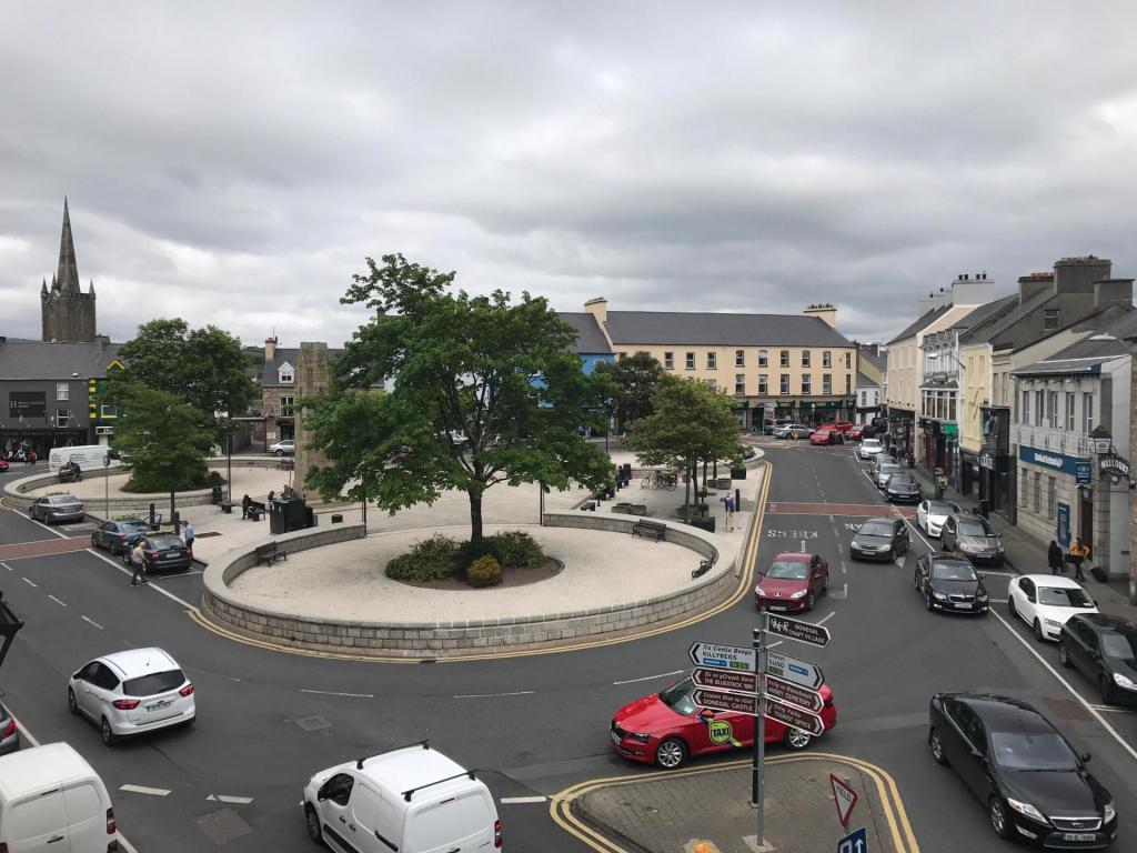
The route bends back towards Donegal Town avoiding the main road by using some of the back roads that wind around Rossnowlagh and Murvagh, both locations of beautiful beaches but both unfortunately out of sight. It eventually spits back out on the main road back at Laghey but only for a couple of KM before heading into Donegal Town centre and back out the Killybegs Road.
Dunleavys Spar on the outside of town gave me the perfect opportunity for a sandwich, tea, water top up and a toilet break at 65km. As the showers were drying up and the sun showing its face I was also finally able to remove my Sportful water resistant gillet and enjoy the weather.
The improving weather nicely coincided with some of the more scenic sections. Heading out the main road towards Mountcharles the route takes a left down to the coast and follows a beautiful coast road around the bay. Views were fantastic across to Co. Sligo and Mayo as well as further along Donegal Bay. After a few KM the route turned more Northerly and the climbing work began.
At this stage I was climbing for most of the next 12km until reaching the top of the ridge between Frosses and Glenties. This was a bit of a test of my climbing legs and fitness but so far, so good and I was feeling happy about the day so far. I was also starting to head more into the breeze but it was still light and I was sheltered to a large extent by the very ridge I was climbing. Over the other side I was descending towards Glenties and the breeze helped cool me off after the long climb.
The road drops down to the main road between Glenties and Ardara but the route I designed turns off before the last 5km and uses small back roads to approach the outskirts of Ardara. This was my only route miscalculation but it was a bad one. I’ve never ridden these roads and relied on RideWithGPS to plot the route. Unfortunately this took me along a farm lane that was basically rock and mud with large potholes and no tarmac at all. I was extremely worried about damaging my wheels or falling off but also didn’t want to get off and try to walk for fear of soaking my feet or twisting my ankle. I didn’t want to go back and didn’t know where to detour so ended up going on, very slowly and very carefully. Eventually the lane spat me out on some poor but infinitely better tarmac and I was soon back on the road and approaching Ardara. This miscalculation has now been removed and rectified for the next time.
I didn’t enter Ardara proper as I once again used side roads to bypass the town and bring me out on the Narin/Portnoo road. I’ve also decided that this was a bad idea as the next shop isn’t until Letterkenny, almost 70km away. The new route would leave Ardara as an approximate halfway point and a good option for a hot meal or a cup of coffee/tea at the very least, especially important for the colder months.
Leaving Ardara I was now heading straight into the breeze. The sun was still out so I was feeling OK and still confident. This is a lovely scenic area with lots of views but I kept pushing on for the second control. This is at the Dolmen Centre, a community centre named after the Kilclooney Dolmen located a short walk away. As you cycle this area there is a real neolithic feel as there is an amazing amount of large exposed rocks filling the landscape. This whole area must have been deposited with rocks as the ice retreated during the Ice Age. Many of the gardens have embraced the rocks and integrated them into their gardens and landscaping.

The Dolmen Centre was the mid way point for me and I used the picnic bench outside as an opportunity for a break and unfortunately just a cold lunch. I would have loved a cup of tea at this stage as the sun had now disappeared and the wind was getting stronger and colder. It was here that I met a very chatty local lady walking her very furry whippet dog. She had a problem with her electric bike the previous night, left it propped up outside the Church and couldn’t find it today. She seemed very laid back and relaxed that it was missing despite it being her only form of transport so I hope someone just made it safe for her and that she got it back.

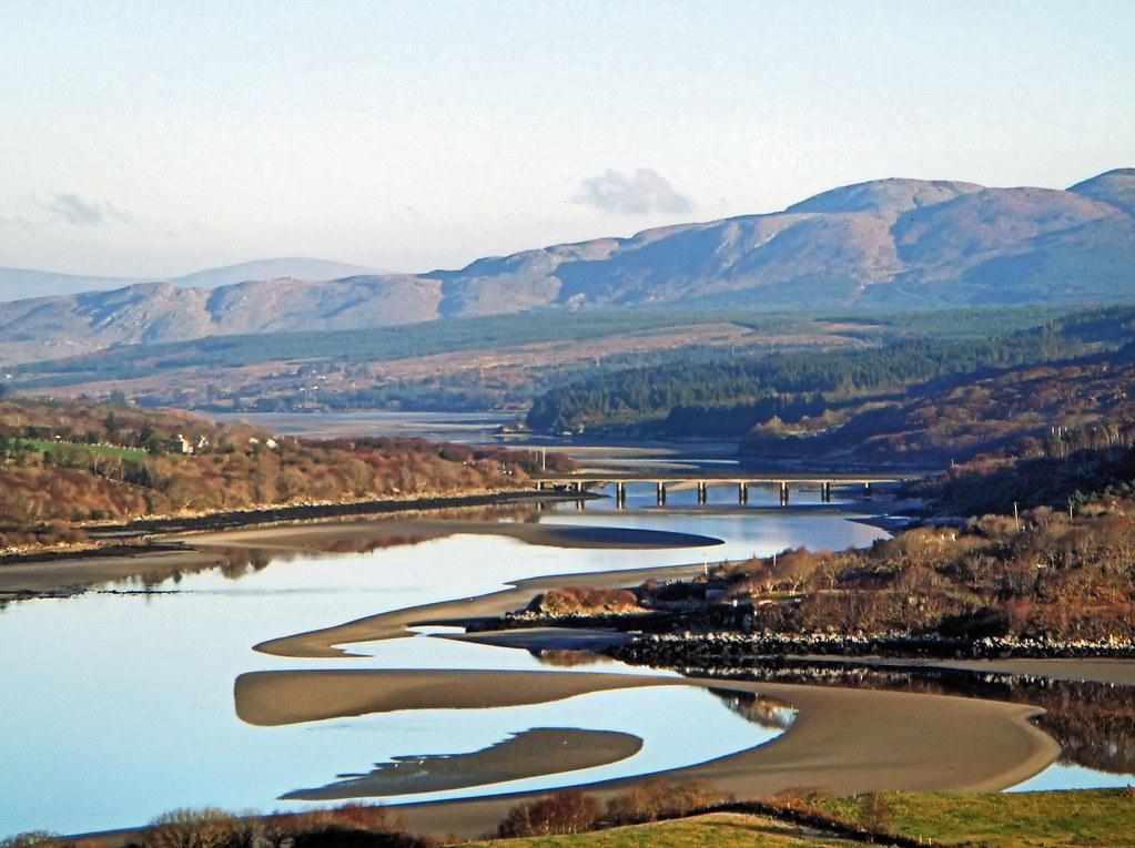
Leaving the Dolmen Centre the road goes through a series of short, steep rolling hills and swings around to the NE. This is where the wind really made itself known. I always struggle with the third quarter of any Audax I’ve done. It seems to be a combination of energy levels both physical and mental. This was also a really hateful section of road. The terrain and the wind seemed to be conspiring against me, I was getting cold and tired and really questioning my decision to go out today. Somehow I dragged myself round the coast to Lettermacaward, across the really impressive Gweebarra Bridge and into Doochary. This section is beautifully scenic but my heart really wasn’t in it and I just focused on keeping the pedals turning on a bike that now seemed to weigh three times what it did earlier.
I stopped again shortly after leaving Doochary. It was simply where I could get pulled in, an unremarkable little stone bridge over a noisy stream, sheltered by some trees and out of the wind. I had some more food and a few jelly babies to try and force some motivation and energy back into me. One of the toughest sections was ahead of me and I didn’t know if I had the strength and will to keep going. I felt as battered and bedraggled as my poor bike!

The next 15km was the hardest cycling I’ve ever done. It’s through the increasingly mountainous and very steady climb to the top of Glenveagh where the Bridal Path meets the main road. Mountainous in Donegal means open and exposed, this is rural Donegal turned up to the max. There is nothing out here except sheep, blanket bog and wind. Unfortunately the wind was now very blustery and cold and straight into my face with no shelter to give respite. For what seemed like hours I ground my way very slowly up this road, head down and struggling to keep my speed above 10km/hr. I lost track of the times I talked myself out of stopping and if I hadn’t been out of network I honestly think I would have pulled the pin and called Catriona to come pick me up.
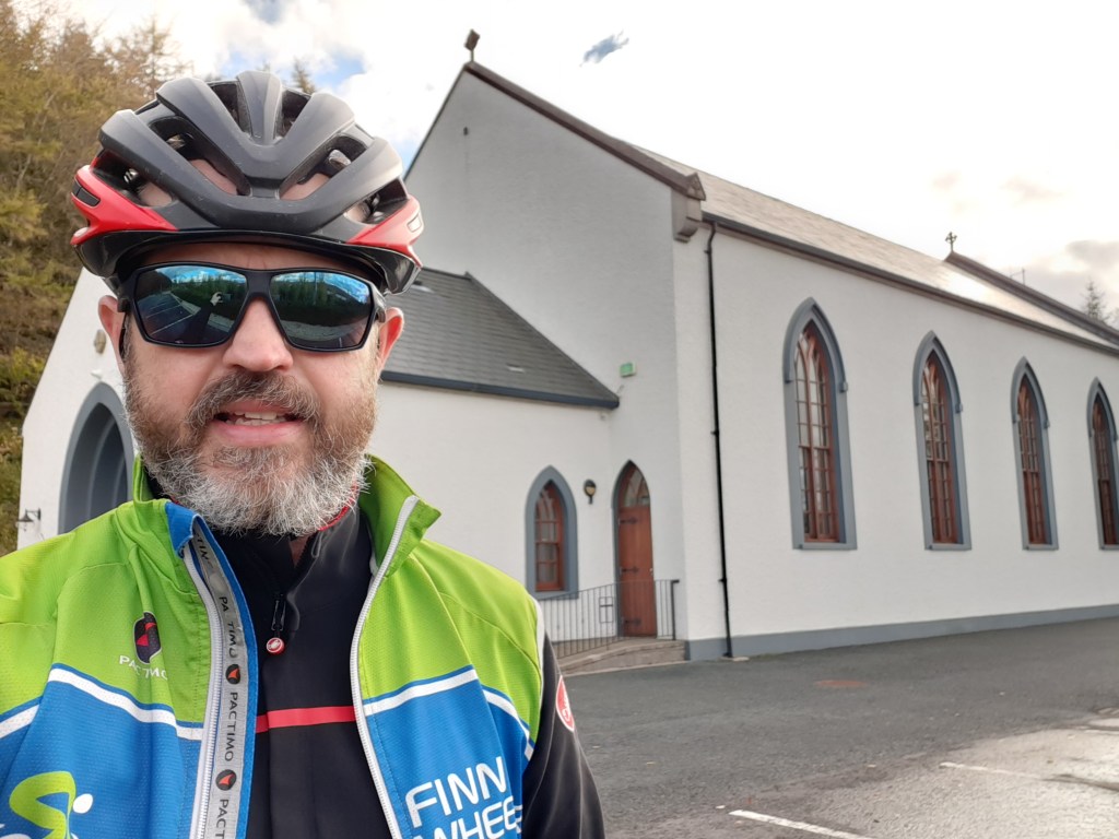
Eventually I reached the top of the climb and faced a long steep descent into Churchill and control 3. I was really looking forward to a break and a chance to recover on the descent but it wasn’t what I expected. I now had the wind buffeting me from the side and I had to concentrate really hard to stop being blown into the side of the road as I passed gaps in the hills where the wind whipped through, seemingly determined to get me yet. Finally reaching the shores of Lough Gartan I was relieved to get shelter from the trees and hedgerows and take a break at the beautiful Glendowan Church on the edge of the lake.
Leaving Glendowan it is straight into a really steep hill that annoyingly turns into a T Junction about 3/4 of the way up. Once over this though I was dropping back down again and through the village of Churchill and heading for Letterkenny. Despite being a rural area this is quite a wide road with a good surface and one I know fairly well. The familiar landmarks of townlands and junctions lifted my spirits and I started thinking about another, final foodstop.
Passing the turn off at Newmills I ignored the irritated beeping of my Garmin and diverted off my course to the service station just under 1km up the road. I desperately needed something warm to eat and drink. Unfortunately the deli was now closed but they had a very welcome tea machine and I couldn’t resist the glazed donuts and a much needed chocolate bar. I sat outside, people watching, enjoying my tea and sugar and finished the last of my sandwiches. The sun was totally gone by now and the temperature dropping so I layered back up with some of the clothing I’d removed what seemed like a week ago in Donegal Town before heading back to the planned route and feeling more optimistic about completion.
This final 40km wasn’t easy but I was very happy that I’d decided to ride it for the first time a couple of weeks ago. I was familiar with the terrain and the junctions and could have ridden it without my Garmin. I knew where I had to conserve energy on the longer climbs and where I could push on to maximise my momentum. I could almost physically feel the miles clicking off and home getting nearer. The sugar infusion combined with an improved mental attitude put energy back into legs that seemed to have given up not that long ago.
In typical Irish tradition the wind that now should have been an assisting tailwind had dropped off as I came back down to lower levels and while it was still there it wasn’t the helping push I’d hoped for. Almost before I knew it though I was over the last hill into Raphoe and dropping down the fast descent into town. I think I may even have been smiling again!
A quick stop in Raphoe to take the control photo, text Catriona to say I’d be home in less than an hour and I was away again, sugar levels topped up with a handful of jelly babies and with a reserve in my back pocket.
This last section isn’t easy. There are a number of rolling, steep climbs and one quite long climb from Ballindrait but I could smell home. These are roads I know well and I had renewed energy now that I knew it was almost finished. As I came over the top of the hill between Ballindrait and Castlefinn the sun was setting in the distance, just below the cloud level and I had a stunning view out over the Finn Valley and towards home.
20 minutes later I was rolling up the drive to the house. I was absolutely exhausted. This was one of the toughest cycles I’d ever done, physically and mentally and it almost broke me. Importantly though it didn’t!
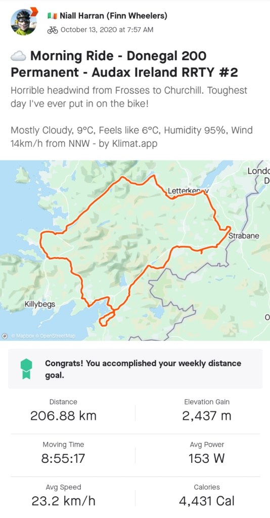
At 207km and almost 2,500m of climbing it’s also one of the most challenging I’ve done. As Donegal has now been moved to Level 4 restrictions until November 10th it looks like I’ll need it for at least one more month to keep RRTY going. Let’s hope the wind is more favourable next time.

sounds brutal and a very big day out. Now do it backwards lol. Well done
LikeLiked by 1 person
Sounds like fun, but only if I can do it on my e-bike.
LikeLiked by 1 person
Wow!! Sounds very tough – fair play to you for finishing!
LikeLiked by 1 person
Pingback: november | the idle cyclist
Pingback: metric challenge: december | the idle cyclist
Pingback: metric challenge 2021: may | the idle cyclist
Pingback: imperial century | the idle cyclist
Pingback: rrty – here we go again! | the idle cyclist
Pingback: rrty #2 – july – donegal 200 | the idle cyclist