Video record of my big day on The Bluestack Way.
Video: This Is The Way
5 Replies

Video record of my big day on The Bluestack Way.
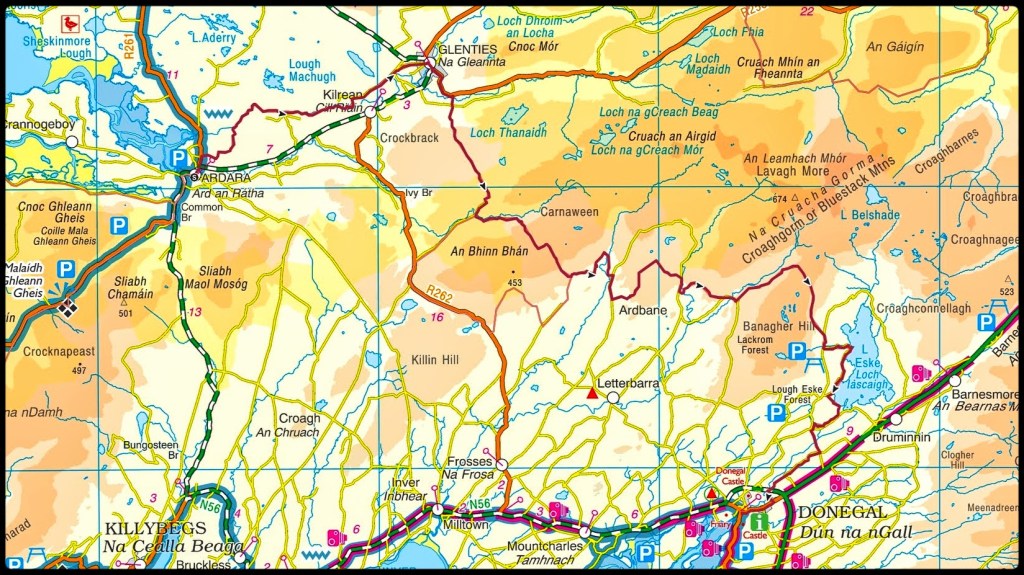
So I finally did it! The Bluestack Way in a Day – 52km from Ardara to Donegal Town via Glenties on a mixture of tarmac roads, forest and bog tracks and some open hillside. It’s one of my biggest achievements and also one of the hardest, most physically and mentally demanding things I’ve ever done!
My original date that I decided on way back in May was Sunday 27th August. This gave me 12 weeks to “train” and also gave me a good window of daylight to complete the walk. My aim was to start at 730am, aiming for a 12hr finish but planning for 14hrs if needed. Going from Ardara meant that the last 10km were on tarmac roads and easier and safer to walk in the dark, if necessary, with a headtorch and hi viz jacket.
I also had a mental option to delay by one week to allow for any last minute issues such as injury or weather. In the end up I did delay and the walk ended up happening on Sunday 3rd September. The previous Sunday was a day of heavy rain and I decided the walk was difficult enough without trying to complete it in conditions like that. Plus the long range forecasts were all shouting about a change in the weather to warm and dry with Sunday 3rd looking pretty much perfect.
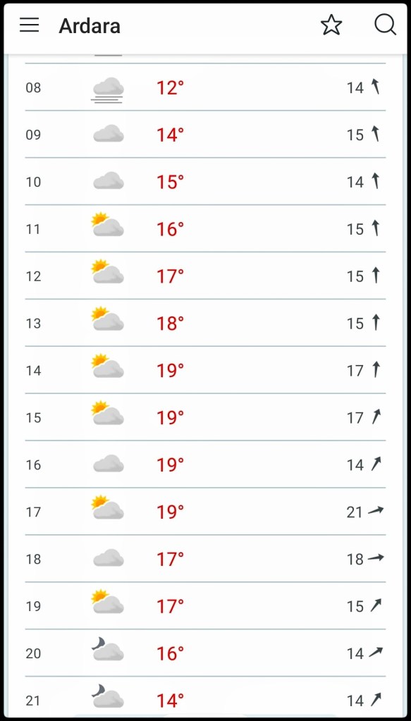
The final decision to postpone wasn’t made until Saturday 26th so the week running up to this was my prep week for the event with 2 x 20km walks at the weekend and a few shorter 5km walks mid week before resting a few days. I was also in bed by 930pm each night trying to build my reserves for the weekend. I was mentally focused and ready to go. The deflation of not going on Sunday kind of caught me unawares and left me feeling very unfocused in to Monday, like post-event blues without the event! It was a real effort to build myself back up for the weekend and I ended up going into Sunday feeling less prepared and pretty nervous.
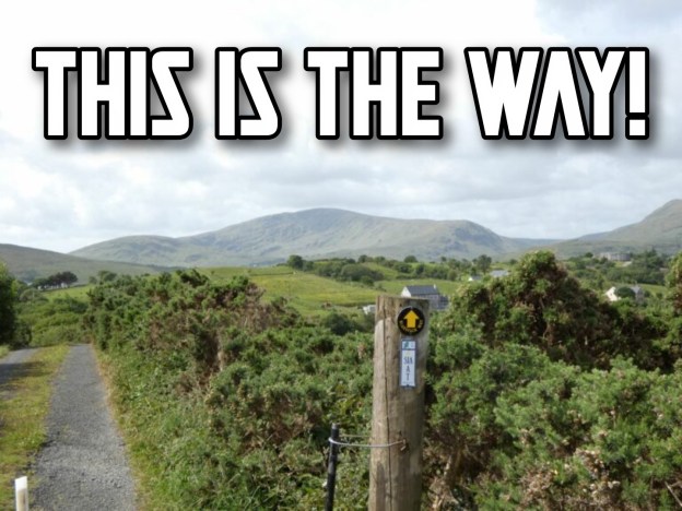
We left home just after 6am for the 1hr drive to Ardara with nerves gradually building in my belly the whole way. Getting out of the car in an eerily quiet and grey Ardara my legs felt quite wobbly and I had a brief moment of panic. A big hug and kiss from Catriona and I told her to head home to give me a chance to settle myself and get started – no way back now! I took a couple of quick and shaky shots of the first sign post of the day, settled my bags, pressed start on my Garmin and took my first of what turned out to be 69,728 steps.

I was really looking forward to this first section to Glenties as it was totally unknown to me. I’d watched a couple of videos on YouTube of other people that had walked the Bluestack Way and knew that a lot of it was along the banks of the Owenea River. ToughSoles in particular were big fans of this section and I hoped to enjoy it.
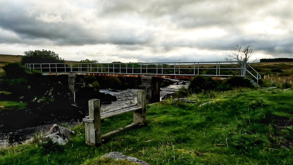
The river was beautiful. After a short section through the town and a gravelled track I wound down to the river. It’s obviously a popular fishing spot with proper bridges and clear tracks on both banks with stiles and boardwalks to help cross fences and boggy sections. Along the way I saw quite a few ducks, most of them flapping away startled by my presence on this early morning. I also heard a few fish rising for early flies and judging by the noise and resulting rings in the water they must have been pretty sizeable. I was hoping to see herons along the river but I suspect they wouldn’t be too popular with the local fishermen and have probably been discouraged from settling in the area.

A lot of the riverside path is bordered on each side by bracken. Enterprising spiders have realised that spinning a huge web across the path will trap insects as they fly between. Unfortunately for them I was having to destroy all their hard work by breaking down their webs to get past. It felt like a cross between Indiana Jones and Lord of the Rings as the spiders were huge and obviously (normally!) well fed. Most of them were about the size of a 20c/2p coin and I really didn’t fancy having them crawling on my bare legs, especially pissed off having had their web destroyed!
Eventually it was time to leave the river and skirting the edge of a field I followed the path to the first tarmac since leaving Ardara. A 3.5km straight run brought me to the edge of Glenties and along the main street exiting the town on the back road to Ballybofey beside the Garda station. A surprisingly well maintained and clean public toilet (must be the only remaining Council operated toilet in Donegal!) allowed me the luxury of not having to dig a cat hole in the wilds because no matter how much I enjoy the outdoors nobody likes having a dump outside!
Leaving a very highly decorated Glenties (this was the weekend of the Harvest Festival) I followed the tarmac road for approximately 1.5km before crossing back over the now much narrower Owenea River and back on to gravel tracks. The road out of Glenties was much more pleasant than the way in as it wound through sections of large trees with nice cottages and houses with quirky garden displays. This was my last signs of civilisation until arriving in Donegal Town almost 40km later!
The gravel track climbed steeply away from the river taking me past long abandoned homes and farmyards still locked up and quiet on this Sunday morning. This was a bit of a lung-buster with slippery conditions underfoot and a number of gates and stiles to negotiate but taking breathers and looking back I could see how quickly I was gaining height with great views back over Glenties, back towards Ardara and out towards the coast with Slievetooey looming away off in the distance.
Eventually reaching the top of this low ridge I got my first proper views of the Bluestack range itself. The track ahead ran in an almost straight line for 2-3km with a variety of conditions underfoot from gravelly to squelchy sections of bog, some bare of vegetation for 10-20m at a time while other sections were overgrown with long grass and small bushes. This was my first indication that the terrain was going to be a lot wetter than expected and that I’d made a mistake with my decision to wear trail shoes.
The first section of this bog track was very exposed with a strong Westerly wind, the first and only windy section of the whole day. After approximately 1km I reached a forested section with the trees on my left somehow reducing the force of the wind coming from my right. The breeze was still strong enough to keep me from overheating in what had turned into a very sunny day as well as preventing any midges from coming out to feast.
This boggy track eventually reached a gate and a much better surfaced forest access trail. Coming around the next corner I had a sudden recognition of this spot from walking the 30km Bluestack Challenge Walk in 2012. This was where the Army had set up a tented food station with bacon baps and tea. I could have murdered one of those at this stage today!
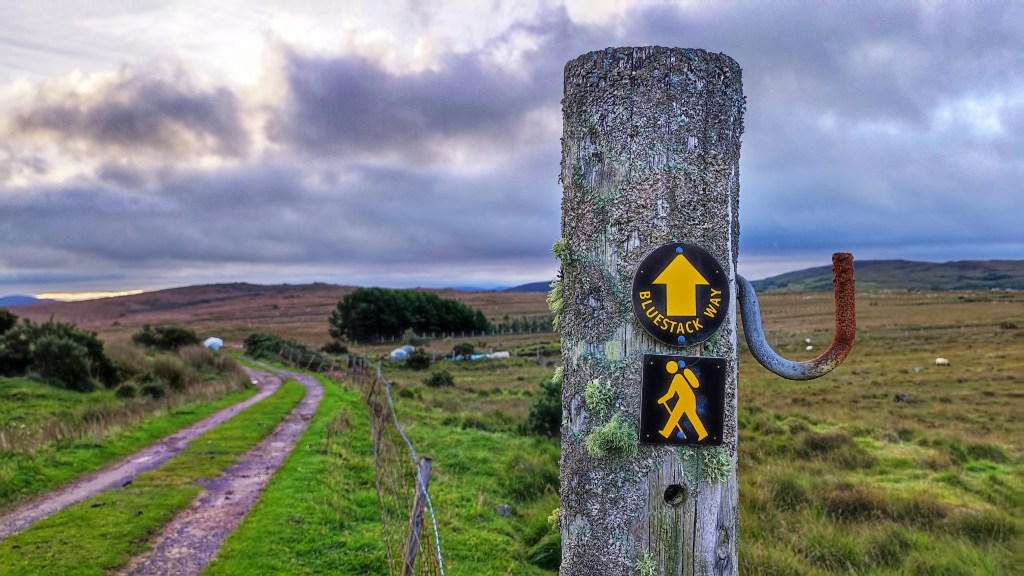
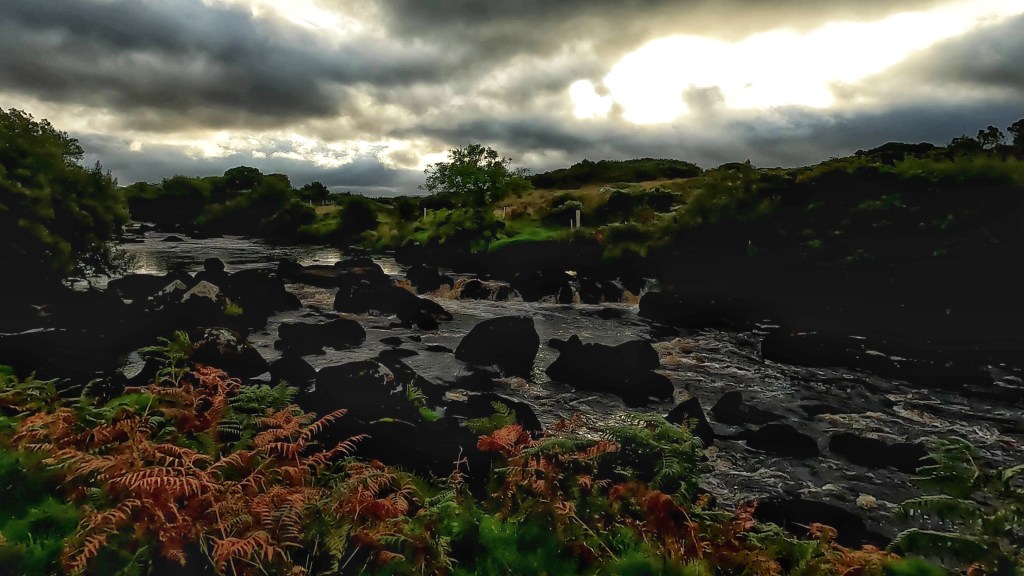
Just past this spot the route takes a sharp turn to follow the Owenroe river as it tumbles noisily through the narrow ravine below the track. This is where the alternative “lowland” section also starts. This alternative avoids the higher ground for anyone that doesn’t fancy it or when there is particularly bad weather. I, of course, was taking the high route.
Walking along this track with a mature forest plantation on my right and the river rushing below on my left was really enjoyable. As the path flattened out I had really good views of the craggy summit of Carnaween off to the East. The sun was out and I was feeling good. I was tempted to refill my water from the river but I still had over a litre and didn’t fancy the scramble down and back up from the river. This turned out to be a bad decision as my water choices for the rest of the day were very limited.
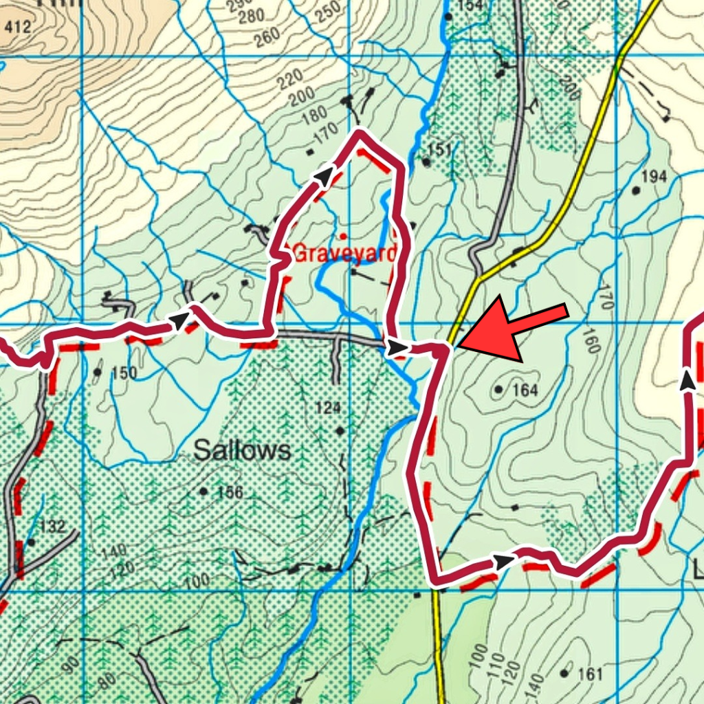
Eventually the track petered out and it was time to head on to the open hillside as the route headed up and over the shallow col below Cloghmeen Hill. At slightly over 400m this was the highest elevation of the whole route. At the access gate a picnic bench sat looking very out of place and seemed like it would be completely in the way of any machinery looking access to the moorland above. An abandoned Race Ireland sign from an old event helpfully told me it was 20km but I’m not sure where from. It did coincide with my distance since Ardara but I think it related to the distance from Lough Eske coming towards Glenties based on the orientation of some signs found further along the route.
It was on the climb over this ridge that the wheels came off the wagon for this walk, where my choice of footwear was proven to be a disaster and this was clear within the first few steps. The terrain changed from track to open grazed moorland, so typical of the Bluestacks. It was also incredibly wet! Every step was a squelch, the ground was saturated with thick moss below the layer of grass. Water was squeezing out of the soil and within 10m my shoes and feet were soaking wet. The climb was steep but not incredibly difficult. However, with tired legs after 20km, shoes that now felt like blocks of concrete and heavy ground it was a slog to the top. At the top of this ridge the route bears left with the official summit of Cloghmeen Hill some 50-100m to the right. My original plan was to make a short detour at this point to grab the summit but with serious concerns about my shoes, the boggy approach to the summit and legs drained after the climb up I decided to focus on getting off the hill instead.
The drop down the other side of the ridge was steeper than the ascent but just as wet and I’m sure it was here that the majority of the damage was done to my feet. With socks and shoes completely sodden my feet were moving far more than usual in my shoes and my weight was focused towards the front of my feet creating friction that wet skin could do without. By the time I reached the bottom, followed the route as it inexplicably weaved through the walls of an abandoned and overgrown homestead and out to the gravel track where it rejoined with the alternative route, I knew I was going to have problems for the rest of the day. I could feel a burning sensation on the pads of both feet, just behind my toes as well as on the heel of my right foot despite having it really well taped specifically to prevent blisters.
My original plan was always to take a longer break at Letterbarrow soccer pitch which was at the 27/28km mark. I’d planned to get my shoes off, retape my feet and put on fresh socks. This was going to be even more crucial now than I had planned.
The Bluestack Way takes what seems like a random loop just a few hundred metres from Letterbarrow pitch. It brings you back to the same road having walked an extra kilometre up and down a fairly steep hillside. The aim is not to piss you off but to bring you past the ancient Disert Graveyard. Again, on any other day I would have been tempted to pay this spot a visit but I pushed on past the entrance, focused on getting to the pitch and getting my shoes off.
The one advantage of the extra walk was that my feet squeezed most of the water out of my shoes leaving them a tiny bit drier and not completely waterlogged. Reaching a picnic bench at the back of the clubhouse it was like heaven to finally sit down on a proper seat and peel off my sodden socks. Leaving my shoes in the strong sunshine I let my feet dry out and breathe in the warm air for 20min while I lay back and rested having eaten most of a flapjack bar to fill my belly. Restarting with fresh tape, blister patches and clean, dry socks my feet, though tender, felt so much better.
I had also hoped for an outside tap at the clubhouse but there was none. Reading the rules for an unsupported FKT attempt I since realised that water can only be taken from natural sources so it’s just as well!
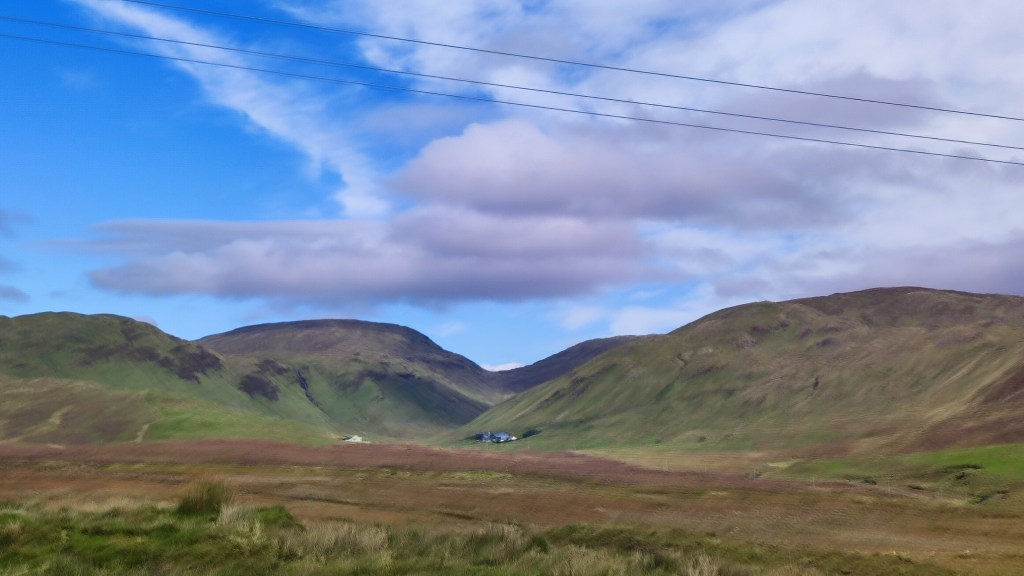
A short section of tarmac route and I was once again diverting on to gravel tracks. The first section was through a farmyard with loads of warning signs on the gate about trespassing and liability etc. It was all a bit intimidating but the waypoint signs gave me the confidence to keep on. A few more gates with similar signs and I was in a short section of cool, shady forestry before popping out on a wide flat bog area with beautiful, expansive views of the high Bluestack range. I could pick out some familiar hills and had a brilliant view of the Sruell Gap and just a peek of The Grey Mare’s Tail waterfall that I saw up close a few months ago.

This section of bog is also extensively used for turf harvesting. There were some stacks of bags sitting ready to be taken home with many more bags sitting in rows ready for lifting. There was one group of men busily loading a quad trailer and transferring bags to a tractor trailer for taking home. Harvesting turf is very labour intensive and I often wonder if the payback is worth the effort involved. One thing for sure though is that turf will heat you many times over, not just when you burn it!
A sharp right turn in the middle of the bog brought me back to tarmac and the familiar road that takes you to the start of Sruell Gap. A short walk along this remote single track road and I was sent on to another track and over a concrete slab bridge across the Sruell River as it tumbled down from the gap. Over the bridge and it was back to a low section of trackless grassland. Boggy again but thankfully not a sponge like earlier and I was able to find enough rocky spots and firmish ground to avoid any more water getting in to my shoes. If anyone saw me gingerly stepping across the fields I must have been like a middle aged child trying to avoid the cracks on a pavement!
It was somewhere across this section that I passed the 33km mark and was now officially on the longest walk I’d ever done in a day. My previous record was 33.1km in March 2022
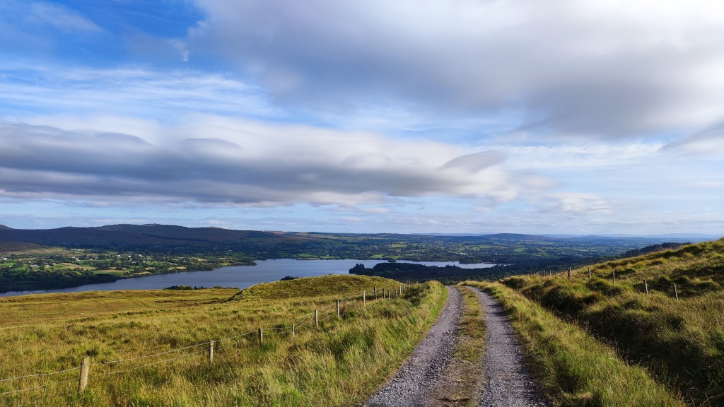
Another short section of tarmac brought me to the Eglish River and a very familiar gravel trail that curves around Banagher Hill and along the Eglish Valley with more expansive views of the Bluestack ridge. I’ve been on the lower section of this track a number of times, most recently just 4 weeks ago, so I was really beginning to feel like I was on home ground now. The track ascends gently as it rounds Banagher Hill until eventually you are rewarded with the very welcome view out over beautiful Lough Eske and Donegal Town in the distance. Still 13km to go but I could sense the end.
For the next 3km it was a steady downhill on gravel which eventually morphed into tarmac, steadily dropping down towards Lough Eske. On the way down I met a lady with her dog She asked if I was walking the Bluestack Way and was very impressed when she asked where I started and I said Ardara. Her jaw nearly hit the floor when I told her I was going the whole way to Donegal Town. She hopes to walk it in two days and was amazed I was doing it in one!
I really needed this boost though. The dampness from my shoes had now penetrated both pairs of dry socks and I was back to walking with wet and increasingly painful feet. The pads of both feet and my right heel were burning, a sure sign that blisters were developing. At this stage it was now a matter of every step was one step closer to the end.
Once down close to Lough Eske I joined the fairly busy scenic road that loops around the West shore but thankfully only for a few hundred metres as lots of people were out for a drive on this lovely Sunday afternoon.
The route leaves the road to descend through the tree-lined narrow road that skirts the edge of Ardamona Nature Reserve and the very edge of the lough before arriving at Harvey’s Point Hotel. Just before the turnoff I was finally able to get access to the small Clady River as it tumbled down the steep hillside from Banagher Lough high up in the mountains above. My water bladder was completely empty and I had no water for almost an hour at this stage. I wasn’t happy with any water sources up to now as the route had come through grassland that was heavily grazed with sheep and nothing was flowing fast enough to give me confidence until now. A couple of shots with my filter gave me almost a litre and enough to keep me going to the end.
Just before Harvey’s Point I passed the significant 42km milestone. In old money this is just over 26 miles and the distance of a marathon. I doubt I’ll ever run a marathon but it felt damn good to have walked one! Still another 10K to go though…
Reaching the hotel entry gates and heading along the road towards the Famine Pot junction I was tormented by cars and a couple of buses. This is a popular hotel and this is the only access road. After the peace and tranquility of the whole day up to now this was a real culture shock and I was very relieved to see the marker post sending me off the road and into the forest that surrounds Lough Eske Castle Hotel right on the lough shore and thankfully away from all the traffic.
This section was absolutely gorgeous but I was really starting to suffer at this stage and couldn’t enjoy it anywhere close to what it deserved. It was a wonderfully cool variety of shaded forest paths and gravelly tracks through the trees and boardwalk right on the very edge of the lake. Swans and ducks were enjoying the water which was visible through small breaks in the tall shoreline foliage. The path meanders through this beautifully tranquil area for approximately 3km but to me it felt like an eternity. In among the trees I lost all sense of progress and every step felt like walking on broken glass. I hit a massive low point through here and for the first time really felt like packing it in. Even eating was a chore with the flapjack bar feeling like sawdust in my mouth and having to be forced down. Looking back I was probably suffering from dehydration and maybe even a touch of heatstroke at this point.
I have a memory of leaning on the rail of a small bridge over a little stream, my forehead resting on the wood, arms dangling loosely and feeling for all the world like I could burst into tears. My feet were in bits and my head was gone. Somehow I managed to drag myself out of this and forced myself to get moving. I had about 7-8km left and couldn’t give up now!
Emerging from the never ending tunnel of trees (usually my favourite environment!) I came back to the road at a junction I’ve driven through maybe a hundred times. It was here that the switch flipped back to positive. Despite having at least another hour to go to reach Donegal Town this was the first point where I thought “I’m gonna do this!“. Every step was horribly painful but every step was closer to the end, I just kept repeating this in my head as I trudged along the narrow little rural road towards town.
Along the way there were three steep little hills, those you would think nothing of regularly, the ones on a bike where you keep the high gear, stand up and push for the top to keep momentum and enjoy the short, fast descent on the other side. Today they were agony, heavy, tired legs on the climb up and burning, blistered feet on the other side. “Every step is another step closer to the end“…..
Suddenly I seemed to be approaching the busy bypass that skirts around the edge of Donegal Town. The volume and speed of traffic had me in a bit of a panic that I wouldn’t be able to cross safely, shuffling along as I was, hardly able to walk never mind run! Then, just before the junction, a small waymarker sent me to the right via a barely visible narrow footpath that went through the hedge, dropped down to a wild and noisy River Eske, past a very impressive and noisy waterfall, passed under the main road and out the other side to a housing estate on the edge of town.
Looking at the map at home I thought that I was to come out in the town via the old railway yard and close to the Diamond. Entering this housing estate I thought I was close to the end. Walking through to the main road I suddenly realised I was wrong, I was on the far eastern edge of town and still had well over a full kilometre to go but “Every step is another step closer to the end“…..
I have to say I absolutely hated this last section. It was totally unexpected, on footpaths beside a busy road and seemed to go on for ever! I was meeting people out for a Sunday evening walk and I must have looked like shit, I certainly felt like I did anyway. It was a real effort to summon enough energy to reply to friendly smiles and hellos and I’m sure they must have thought I was a complete weirdo!
Eventually I reached the Church and could feel the road start to slope down towards the Diamond. Rounding a final corner I could see it ahead and all of a sudden I saw Catriona getting out of the car. Her hand in mine, a quick hug and kiss felt like the best feeling in the world but I couldn’t stop, I was afraid I wouldn’t start again! I switched on the GoPro, and she scooted ahead to film my on the final hundred metres into the Diamond and to the marker commemorative stone at the far side where I slumped down, physically and mentally exhausted and totally unable to film a final piece on camera. But, I’d done it, I’d walked “The Bluestack Way in a Day!” I’d actually bloody done it and despite being wrecked I was overjoyed…..
52.15km, 13hrs19min38sec, 69,728 steps.


A fine WordPress.com site
Restoration of a 175 year old cottage
Living life with less baggage!
Like Mother Teresa, only better.
Tandem Randonneuring and Touring in the Washington, D.C. Region
Feeding the birds and hoping for something in return
Simple messages to inspire and generate happiness
A blog about being fifty-ish, keeping fit, and acting the fool...
Incoherent ranting & cries from the edge of sanity, mostly.
Botulism doesn't pay the bills.
outdoor, travel & lifestyle blog for curious minds and wandering feet wherever they may be
Daniel's Cycling Journal
Enjoy the observations, rants, musical offerings and photos of a guy growing old with attitude.
The place to share and find Ireland walking stories
The musings and observations of someone who restores and rides old skip-rescue bikes
a blog mostly about running, keeping fit, training for triathlons and taking pictures
occasional posts by risa aratyr
All things Paul!
Landscape, hill walking and nature photography from around Ireland
Life is all about the journey.
The goal here is to help you keep cycling on a budget.
The World's Best Guide To Cold & Open Water Swimming
We are all just babes in the woods.
By Tim Broken
Life in the Slow Lane
Journal of a Roscommon Audax Cyclist
Musings of a trekking author
Outdoors / Travel / Writing / Photography / Video / Websites
Ramblings of a Scottish cyclist, A-Z marathon runner and munroist.
One life, some bicycles. A million possibilities, zero clue!
A family hiking blog around ireland
Cycling for fun and fitness everywhere I go.
accessories sold separately
stories from the saddle (c) 2015-2026 jm de leon
My journey from a sedentary life to the world of cycling
Finding motivation to love riding!
